Skip past header information
USGS - science for a changing world
NOAA Logo with link to NOAA Home Page.CT DEEP Logo with link to CT DEEP Home Page.  

U.S. Geological Survey Open-File Report 2012–1103

Sea-Floor Character and Geology Off the Entrance to the Connecticut River, Northeastern Long Island Sound


Skip past contents information

Title | List of Figures | Conversion Factors | Abstract | Introduction | Setting | Methods | Bathymetry | Sidescan Sonar | Sediment Distribution | Bottom Photography | GIS Data Catalog | Summary | Acknowledgments | References | Contacts


Figure 16. A photograph of the grab sampler used in the study area.

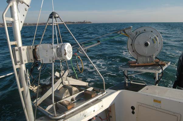
Figure 16. The small Seabed Observation and Sampling System (mini-SEABOSS), a modified van Veen grab sampler equipped with still and video photographic systems, mounted on the aft starboard side of the U.S. Geological Survey Research Vessel Rafael. Note the winch mounted on the davit (left) and the take-up reel for the video-signal and power cable (right).

Skip USGS links group

Accessibility FOIA Privacy Policies and Notices

Take Pride in America logo USAGov logo U.S. Department of the Interior | U.S. Geological Survey
End of USGS links group