Skip past header information
USGS - science for a changing world
NOAA Logo with link to NOAA Home Page.CT DEEP Logo with link to CT DEEP Home Page.  

U.S. Geological Survey Open-File Report 2012–1103

Sea-Floor Character and Geology Off the Entrance to the Connecticut River, Northeastern Long Island Sound


Skip past contents information

Title | List of Figures | Conversion Factors | Abstract | Introduction | Setting | Methods | Bathymetry | Sidescan Sonar | Sediment Distribution | Bottom Photography | GIS Data Catalog | Summary | Acknowledgments | References | Contacts


Figure 23. A detailed image of multibeam bathymetry showing bedrock outcrops in the study area.

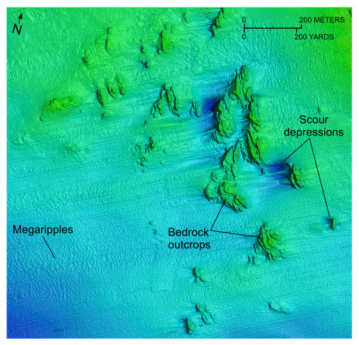
Figure 23. Detailed planar view of the multibeam bathymetric data from National Oceanic and Atmospheric Administration survey H12013 showing bedrock outcrops south of Hatchett Reef. Scour features around the outcrops indicate net westward sediment transport. Location of view is shown in figure 21.

Skip USGS links group

Accessibility FOIA Privacy Policies and Notices

Take Pride in America logo USAGov logo U.S. Department of the Interior | U.S. Geological Survey
End of USGS links group