Skip past header information
USGS - science for a changing world

Open-File Report 2012-1258

High-Resolution Swath Interferometric Data Collected within Muskeget Channel, Massachusetts


Introduction

Skip past contents information
Map showing the location of the Muskeget Channel, Massachusetts, survey area (outlined in red). Is., Island; Pt., Point; UTM, Universal Transverse Mercator.
Figure 1.Map showing the location of the Muskeget Channel, Massachusetts, survey area (outlined in red). Is., Island; Pt., Point; UTM, Universal Transverse Mercator.

Photograph showing the configuration of acquisition equipment on the U.S. Geological Survey research vessel Rafael. The real-time kinematic global positioning system antennae and the swath interferometric-sonar head are located off the bow. Photograph by Dave Foster.

Figure 2. Photograph showing the configuration of acquisition equipment on the U.S. Geological Survey research vessel Rafael. The real-time kinematic global positioning system antennae and the swath interferometric-sonar head are located off the bow. Photograph by Dave Foster.

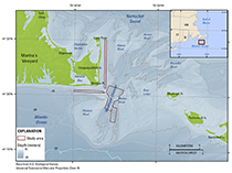
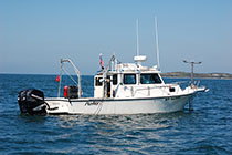
This report contains high-resolution bathymetric and backscatter, sound velocity, and navigation data from approximately 13 square kilometers (km2) of the sea floor within the vicinity of Muskeget Channel, Massachusetts (fig. 1). Data are presented in geospatial, text, and image formats along with Federal Geographic Data Committee (FGDC)-compliant metadata that describe the collection and processing methods used. The data were collected by the U.S. Geological Survey (USGS), in cooperation with the Woods Hole Oceanographic Institution, to assess the effect on sediment transport and morphologic change within Muskeget Channel if tidal instream energy conversion facilities were installed for energy generation for the town of Edgartown, Mass. These data were acquired during USGS field activity 2010–072–FA onboard USGS research vessel (RV) Rafael in fall 2010 (fig. 2).


Muskeget Channel lies between Chappaquiddick Island off the southeastern coast of Martha’s Vineyard, Mass., and Muskeget Island at the western end of Nantucket, Mass. (fig. 1). The thalweg of the channel runs northeast-southwest, lies approximately 3 kilometers (km) east of Wasque Point, and can experience spring tidal currents in excess of 2 meters per second (m/s; Howes and others, 2011). The town of Edgartown, Mass., is investigating the feasibility of using marine hydrokinetic technology to generate electricity from the strong tidal currents in Muskeget Channel. The high-resolution bathymetric data presented here were collected to characterize the channel morphology and large-scale (tens of meters in wavelength) bedforms surrounding the channel as well as two potential cable routes between Martha's Vineyard and Muskeget Channel. More information on the Muskeget Tidal Energy Project can be obtained from the New England Marine Renewable Energy Center (http://www.mrec.umassd.edu/resourcecenter/muskegettidalproject/).

Accessibility FOIA Privacy Policies and Notices

Take Pride in America logo USA.gov logo U.S. Department of the Interior | U.S. Geological Survey
URL: http://pubsdata.usgs.gov/pubs/of/2012/1258/html/ofr2012-1258_intro.html
Page Contact Information: GS Pubs Web Contact
Page Last Modified: Monday, 02-Jun-2014 13:17:38 EDT