Open-File Report 2012-1266
Bathymetric Terrain Model of the Atlantic Margin for Marine Geological Investigations
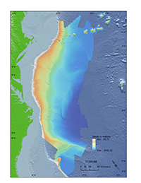
The purpose of the bathymetric terrain model presented in this report is to provide a high-quality bathymetric surface of the Atlantic margin of the United States that can be used to augment current and future marine geological investigations. Advances in acquisition and processing technologies of bathymetric data have facilitated the creation of high-resolution bathymetric surfaces that approach the resolution of similar surfaces available for onshore investigations. These bathymetric terrain models provide a detailed representation of the Earth's subaqueous surface and, when combined with other geophysical and geological datasets, allow for interpretation of modern and ancient geological processes. The input data for this bathymetric terrain model, covering approximately 725,000 square kilometers, were acquired between 1990 and 2015 by several sources, including the U.S. Geological Survey (USGS), the National Oceanic and Atmospheric Administration (NOAA), and the University of New Hampshire (UNH). The bathymetric data published in this report were compiled as part of a project funded by the Nuclear Regulatory Commission (NRC) to evaluate tsunami hazards along the East Coast of the United States (ten Brink and others, 2010). This hazards analysis research required a high-quality bathymetric terrain model (BTM) to identify and characterize submarine landslides capable of generating tsunamis in order to assess potential tsunami impacts to nuclear power plants along the Atlantic coast (fig. 1). The BTM provided a consistent framework for hazard-assessment along the Atlantic margin of the United States, aiding in the interpretation of other geophysical and geological datasets (seismic data and sediment cores), allowing for the extraction of pertinent statistical risk parameters, and helping scientists to focus on critical areas for future data collection (Chaytor and others, 2009, 2011, 2012a,b; ten Brink and others, 2009, 2011, 2012, 2014; Flores and others, 2011; Geist and others, 2009, Brothers and others, 2013). The compilation benefited from bathymetric data collected by NOAA and the UNH Center for Coastal and Ocean Mapping/Joint Hydrographic Center (CCOM/JHC) for the U.S. Extended Continental Shelf (ECS) program. The ECS program collected bathymetric data (from 2004 through 2015) on the slope and rise of the Atlantic margin (Gardner, 2004; Cartwright and Gardner, 2005; Calder and Gardner; 2008, Armstrong and others, 2012; Calder, 2015) as part of the evaluation of a potential ECS delineation by the United States within the framework of the United Nations Convention on the Law of the Sea (Gardner and others, 2006). Beyond the applied use of the bathymetric compilation in hazard characterization, the BTM provides a spatially consistent dataset for investigating modern and ancient geological processes along a passive margin that contains glacial, fluvial, and carbonate environments (for example, Twichell and others, 2009; Chaytor and others, 2012b; Brothers and others, 2013) and in support of habitat evaluations, physical oceanographic studies, and other evaluations of the sea floor off the coast of the eastern United States (Quattrini and others, 2015). |

![]() U.S. Department of the Interior |
U.S. Geological Survey
U.S. Department of the Interior |
U.S. Geological Survey
URL: http://pubsdata.usgs.gov/pubs/of/2012/1266/introduction.html
Page Contact Information: GS Pubs Web Contact
Page Last Modified: Wednesday, 18-May-2016 18:00:28 EDT