
|
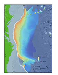 |
Figure 1. Map showing the location of the Atlantic margin and the extent of the bathymetric terrain model seaward of the U.S. Atlantic coast published in this report. Land elevations in green and additional regional bathymetry in light blue are for basemap purposes only and are not published in this report. Data are from the University of New Hampshire, U.S. Geological Survey, and the National Oceanic and Atmospheric Administration National Centers for Environmental Information. Max, maximum; Min, minimum. |
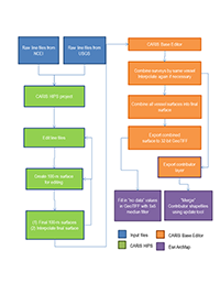 |
Figure 2. Generalized flow diagram showing the methods used to process raw multibeam files into final data products published in this report. CARIS HIPS, CARIS Hydrographic Information Processing System; GeoTIFF, georeferenced tagged image file format; m, meters; NCEI, National Oceanic and Atmospheric Administration National Centers for Environmental Information; USGS, U.S. Geological Survey. |
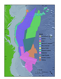 |
Figure 3. Map showing the source surveys (color coded by survey vessel) used to compile the final bathymetric terrain model and published as an Esri shapefile in this report. Surveys are listed in appendix 1. Land elevations in green and regional bathymetry in light blue are for basemap purposes only and are not published in this report. Data are from the U.S. Geological Survey and the National Oceanic and Atmospheric Administration National Centers for Environmental Information. |
|

