Open-File Report 2014–1159
Supporting ObservationsSupporting data (meteorological conditions) as determined by National Oceanic and Atmospheric Administration (NOAA) National Data Buoy Center (NDBC), are provided below. Meteorological observations of wind speed and direction, wave height, sea-surface temperature, and barometric pressure were recorded by instruments maintained offshore of Fire Island by the NOAA NDBC. These data offer an assessment of the environmental conditions during the study period. Here we provide links to data from NOAA NDBC stations 44025 and 44065. Sensor locations for these ancillary data are shown in fig. 14.
|
Click on the following figures for larger images in PDF format. 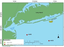 Figure 14. Map showing locations for supporting observations offshore of Fire Island, New York. NDBC, National Data Buoy Center; USGS, U.S. Geological Survey |

![]() U.S. Department of the Interior |
U.S. Geological Survey
U.S. Department of the Interior |
U.S. Geological Survey
URL: http://pubsdata.usgs.gov/pubs/of/2014/1159/ofr2014-1159-observe.html
Page Contact Information: GS Pubs Web Contact
Page Last Modified: Wednesday, 07-Dec-2016 20:05:32 EST
