Open-File Report 2014-1160
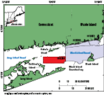
IntroductionThe U.S. Geological Survey (USGS) is working in cooperation with the National Oceanic and Atmospheric Administration (NOAA) to map and interpret the sea-floor geomorphology and sedimentary environments along the southern coast of New England and New York. This study area covers 162 square kilometers of the sea floor in Block Island Sound, northeast of Gardiners Island, New York (fig. 1). In order to distinguish features on the sea floor and map the sedimentary environments, we use multibeam-echosounder (MBES) data, originally collected by NOAA in 2011 to update hydrographic charts, along with sediment samples, bottom video, and still photographs, collected at 37 stations in the study area by the USGS in 2013. The purposes of this report are to (1) interpret the sea-floor features and sedimentary environments in the study area and (2) release the MBES, sediment, and photographic data collected from this area. These data and interpretations can be used to produce base maps important for studies on topics such as benthic ecology and resource management. |

![]() U.S. Department of the Interior |
U.S. Geological Survey
U.S. Department of the Interior |
U.S. Geological Survey
URL: http://pubsdata.usgs.gov/pubs/of/2014/1160/html/ofr2014-1160-intro.html
Page Contact Information: GS Pubs Web Contact
Page Last Modified: Wednesday, 07-Dec-2016 19:37:54 EST