 |
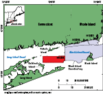
Figure 1. Index map showing the National Oceanic and Atmospheric Administration survey H12299 study area (red polygon) in western Block Island Sound. Also shown are other surveys in Block Island Sound interpreted as part of this series (gray polygons) including H12296 (McMullen and others, 2014); H12023 (McMullen and others, 2013); and Block Island Sound survey, a combination of surveys H12009, H12010, H12011, H12015, H12033, H12137, and H12139 (Poppe and others, 2012). |
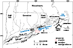 |
Figure 2. Map of end moraines (black-shaded polygons) and submerged ridges (dashed lines) in southern New York and New England (modified from Gustavson and Boothroyd, 1987) along with the study area (red-outlined polygon). The Ronkonkoma-Block Island-Nantucket terminal moraine represents the maximum advance of the Laurentide Ice Sheet about 20,000 to 28,000 years ago, whereas the Harbor Hill-Roanoke Point-Charlestown-Buzzards Bay end moraine represents a retreated ice-sheet position from about 18,000 to 23,000 years ago (Uchupi and others, 2001; Balco, 2011). |
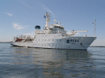 |
Figure 3. Photograph of the National Oceanic and Atmospheric Administration (NOAA) ship Thomas Jefferson at sea. Photograph courtesy of NOAA. |
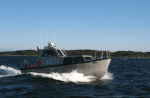 |
Figure 4. Photograph of the National Oceanic and Atmospheric Administration (NOAA) launch 3102, one of two survey launches used to collect multibeam-echosounder data in the study area. Photograph courtesy of NOAA. |
 |
Figure 5. Photograph of a RESON SeaBat 7125 multibeam-echosounder transducer used to collect bathymetric data in the study area. Photograph courtesy of the National Oceanic and Atmospheric Administration. |
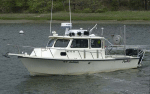 |
Figure 6. Photograph of the U.S. Geological Survey research vessel (RV) Rafael, which was used to collect sediment samples and bottom photography in the study area. |
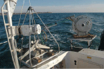 |
Figure 7. Photograph of the U.S. Geological Survey small Seabed Observation and Sampling System (SEABOSS) used to collect sediment samples and bottom photography in the study area. The system consists of a modified Van Veen grab sampler with attached still and video cameras. A winch, mounted on a davit (left), and a take-up reel for the video-signal and power cable (right) were used to deploy the SEABOSS from the aft starboard side of the research vessel Rafael. |
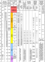 |
Figure 8. Chart showing the relations among phi sizes, millimeter diameters, size classifications (Wentworth, 1922), and American Society for Testing and Materials (ASTM) and Tyler sieve sizes. Chart also shows the corresponding intermediate diameters, grains per milligram, settling velocities, and threshold velocities for traction. Abbreviations in the image include cm/sec, centimeter per second; d, diameter; m, meter; mg, milligram; mm, millimeter; µm, micrometer; no., number; °C, degrees Celsius; and ", inch. Chart produced in the Woods Hole Coastal and Marine Science Center Sedimentation Lab. |
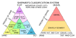 |
Figure 9. Sediment-classification scheme from Shepard (1954), as modified by Schlee (1973) and Poppe and others (2004). Special characters include %, percent; <, less than. |
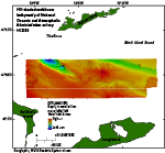 |
Figure 10. Hill-shaded multibeam-bathymetry data collected in National Oceanic and Atmospheric Administration survey H12299. Depths are color coded, such that warm colors (reds) represent shallow areas and cool colors (blues) represent deep areas. |
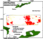 |
Figure 11. Interpretations of the sea floor in the National Oceanic and Atmospheric Administration survey H12299 study area. Outlined areas include sand waves and megaripples, glaciolacustrine sediments, and boulders. Those areas that are not outlined are predominantly modern marine sediments. Interpretations are based on multibeam bathymetry, bottom photography, and sediment samples from the study area. |
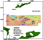 |
Figure 12. Outline of the study area with figure locations of detailed bathymetry (blue rectangles), sand-wave profiles (black lines), and directions of net sediment transport (green arrows) as indicated by sand-wave asymmetry and scour around boulders. |
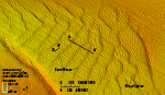 |
Figure 13. Detailed bathymetric image of sand waves and megaripples in the southeastern part of the study area. Sand waves have crests that range from north-south to northeast-southwest, whereas megaripple crests range from north-south to northwest-southeast, becoming almost normal to the sand-wave crests in the west. Locations of sand-wave profiles A-A’ and B-B’ are also shown. Location of image is shown in figure 12. |
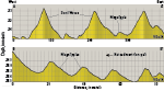 |
Figure 14. Profiles of sand waves (A-A’) and megaripples (B-B’) in the southeastern part of the study area. Symmetrical sand-wave profiles indicate that the sand waves are likely stationary, while the asymmetry of the megaripples indicates net westward sediment transport. Locations of profiles are shown in figures 12 and 13. VE, vertical exaggeration. |
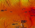 |
Figure 15. Detailed bathymetric image of sinuous transverse sand waves to the west of Cerberus Shoal and boulders on the shoal. Locations of three sediment samples, color-coded according to grain size, and locations of sand-wave profiles D-D’ and E-E’ are also shown. Location of image is shown in figure 12. |
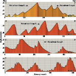 |
Figure 16. Profiles of sand waves to the northwest (C-C’ and D-D’) and southwest (E-E’ and F-F’) of Cerberus Shoal. Sand waves northwest of the shoal indicate that converging net sediment transport maintains a bathymetric high (C-C’) and that elsewhere there is generally eastward transport (D-D’). In the southwest, there is net westward sediment transport (E-E’), and there are areas without a dominant transport direction (F-F’). Locations of profiles D-D’ and E-E’ are shown in figure 15, location of F-F’ is shown in figure 20, and all profile locations are shown in figure 12. VE, vertical exaggeration. |
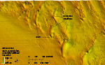 |
Figure 17. Detailed bathymetric image of barchanoid sand waves with moats caused by scour around the ends of their horns. The concave crest orientations with horns pointed eastward indicate net eastward sediment transport in this area. Location of image is shown in figure 12. |
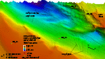 |
Figure 18. Detailed bathymetric image of the tidal-current-scoured bathymetric depression in the northwestern part of the study area, in the vicinity of The Race. The eastern side of the scour depression is rugged, with a gravel pavement on the sea floor, whereas the southern and western sides are sandy and more gradually sloped. Megaripples and sand waves, probably formed from excavated sediments, are visible on the eastern and southern sides of the scour depression. Locations of several sediment samples and their grain sizes and sand-wave profile I-I’ are also shown. Location of image is shown in figure 12. |
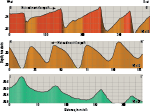 |
Figure 19. Profiles of barchanoid sand waves (G-G’ and H-H’) and transverse megaripples near the current-scoured bathymetric depression (I-I’). Barchanoid sand waves along the western border of the study area indicate eastward net sediment transport (G-G’), whereas those to the southwest of Cerberus Shoal have profiles that indicate westward net sediment transport (H-H’). Transverse megaripples in the bathymetric depression have symmetrical profiles that indicate no dominant net sediment-transport direction. Location of profile H-H’ is shown in figure 20, location of I-I’ is shown in figure 18, and locations of all of the profiles are shown in figure 12. VE, vertical exaggeration. |
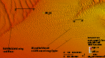 |
Figure 20. Detailed bathymetric image of aligned barchanoid sand waves and megaripples to the southeast of the northward-bifurcating transverse sand waves. The barchanoid waves are aligned such that waves form parallel lines normal to the axes of their crests. Their horns tend to merge with those of nearby sand waves and indicate net westward sediment transport. Locations of a sediment sample and sand-wave profiles F-F’ and H-H’ are also shown. Location of image is shown in figure 12. |
 |
Figure 21. Detailed bathymetric image of smooth-topped, elongate hummocks on the sea floor in the northwestern corner of the study area. We interpret these features to be the eroded remnants of glaciolacustrine deposits covered by a thin layer of mobile sand on the basis of their resistant nature and internal seismic character (Needell and Lewis, 1984). Megaripples can be seen to the south of the glaciolacustrine deposits. Location of image is shown in figure 12. |
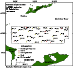 |
Figure 22. Map showing locations of sediment samples collected during cruise 2013-005-FA on the research vessel (RV) Rafael. Sample locations are color-coded according to the grain size of the sample, with gravel and gravelly sediment represented as red and orange and sand as yellow. |
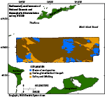 |
Figure 23. Interpretation of sea-floor sedimentary environments in the National Oceanic and Atmospheric Administration survey H12299 study area, including those characterized by erosion or nondeposition, coarse-grained bedload transport, and sorting and reworking. |
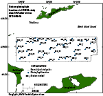 |
Figure 24. Map showing locations of bottom photographs collected during cruise 2013-005-FA on the research vessel (RV) Rafael. Several photographs of the sea floor were collected at each station in the study area. |
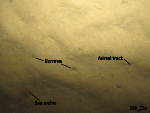 |
Figure 25. Photograph from station 299_22 showing a sandy sea floor in the study area. In this image the sea floor is rippled, animal tracks and burrows are visible, and a sea urchin is present. Location of photograph is shown in figure 24. |
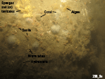 |
Figure 26. Photograph from station 299_9 showing a boulder in the study area that is covered with hydrozoans, sponges and (or) tunicates, coral, and algae. Snails and encrusting worm tubes are also found on the boulder. Location of photograph is shown in figure 24. |

