Open-File Report 2014-1160
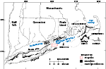
SettingBlock Island Sound is south of Rhode Island; east of Long Island Sound, Fishers Island and Long Island, N.Y.; and west of Rhode Island Sound and Block Island, R.I. (fig. 2). The sea floor in Block Island Sound reflects its glacial history. The Laurentide Ice Sheet once covered Block Island Sound and it reached its maximum southern extent about 20,000 to 28,000 years ago, as is indicated by the Ronkonkoma-Block Island-Nantucket terminal moraine (fig. 2; Stone and Borns, 1986; Uchupi and others, 2001; Ridge, 2003; Balco, 2011). As the ice sheet later regressed northward, it deposited the Harbor Hill-Roanoke Point-Charlestown-Buzzards Bay moraine about 18,000 to 23,000 years ago (fig. 2; Uchupi and others, 2001; Balco, 2011), and other minor undated recessional moraines. Meltwater from the receding ice sheet was impounded north of the terminal and recessional moraines, forming glacial lakes that covered much of present day Long Island, Block Island, and Rhode Island Sounds. Glaciolacustrine sediments, up to hundreds of meters thick in places, were deposited in the lakes and are found underlying the sea floor throughout much of these areas (Needell and others, 1983; Lewis and DiGiacomo-Cohen, 2000; Uchupi and others, 2001; Boothroyd, 2009). The glacial lakes eventually drained as spillways were cut into the moraines (Stone and others, 2005). As the lakes drained, their floors were exposed to subaerial and fluvial erosion and were subsequently flooded and eroded again by the marine transgression associated with eustatic sea-level rise beginning around 15,000 years ago (Stone and others, 2005). As the shoreline transgressed northward across the region, estuarine and marine sediments were deposited and glacial drift was reworked and eroded (Knebel and others, 1982; Needell and Lewis, 1984). Modern marine processes continue to erode and transport sediments on the sea floor in areas of higher energy, while sorting, reworking, and depositing sediments in areas of lower energy. |

![]() U.S. Department of the Interior |
U.S. Geological Survey
U.S. Department of the Interior |
U.S. Geological Survey
URL: http://pubsdata.usgs.gov/pubs/of/2014/1160/html/ofr2014-1160-setting.html
Page Contact Information: GS Pubs Web Contact
Page Last Modified: Wednesday, 07-Dec-2016 19:37:57 EST