Open-File Report 2014-1160
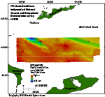
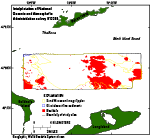
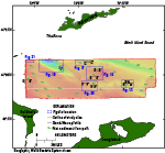
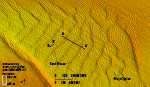
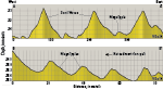
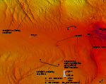
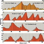
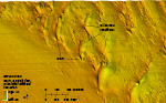
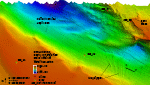
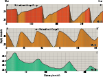
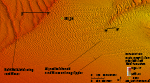
BathymetryWater depths in the study area range from 5 m on Cerberus Shoal, an isolated bathymetric high in the middle of the study area, to 104 m in the bathymetric low in the northwest in the vicinity of The Race (fig. 10). Features visible in the bathymetric data include bedforms, such as sand waves and megaripples, boulders, a large current-scoured bathymetric depression, and exposed glaciolacustrine sediments; areas of the sea floor without distinctive features are covered with modern marine sediments (fig. 11). Bedforms Bedforms visible in the bathymetric data include sand waves and megaripples. Transverse sand waves with sinuous to straight crests, generally oriented north-south, and wavelengths that average about 100 to 200 m are common across the study area where sediment supply is abundant. Many of these sand waves have megaripples with wavelengths averaging several tens of meters on their flanks, suggesting that transport is active. Asymmetry in the sand-wave and megaripple profiles indicates a complex set of net sediment-transport directions is recorded in the study area; however, most of the net sediment transport is to the west (fig. 12). Asymmetry in many sand waves indicates westward transport with a steep western slip face and gently sloped eastern stoss side, though near the center of the western and northern borders of the study area there is eastward transport, and some sand waves are symmetrical and appear to have no dominant transport direction. An area of sand waves in the southeast part of the study area has crest orientations that range from north-south to northeast-southwest, whereas the crests of megaripples on the flanks of the sand waves range from north-south to northwest-southeast, changing from being parallel to the sand waves to being almost normal to them (figs. 12 and 13). Symmetrical profiles of these sand waves suggest they are not moving (profile A-A’; fig. 14); however, profiles of the megaripples indicate westward sediment transport (profile B-B’). The presence of multiple crest orientations suggests turbulence in the water and flow separation (Allen, 1968). The difference between the orientations of sand waves and megaripples could be interpreted as a result of changes in sediment transport directions or of a difference in bedform migration rate. Sand waves to the west of Cerberus Shoal have bifurcating crests; the sand waves in the north tend to bifurcate southward, and the sand waves in the south tend to bifurcate northward (fig. 15). Bifurcating crest morphologies are most common near abrupt edges of sand-wave fields and at contacts between fields of different types of sand waves. A bifurcating crest morphology is expected here because of transitional flow conditions and secondary flow regimes (Aliotta and Perillo, 1987). Also, the crest of a sand wave can bifurcate if tidal flow is not constant along its entire length, especially if differences in flow rate or direction are relatively great (Poppe, Denny, and others, 2007). Sand-wave asymmetry indicates generally eastward sediment transport west of the northern edge of Cerberus Shoal (western part of profile C-C’ and profile D-D’; fig. 16) and westward transport along the southwestern edge of the shoal (profile E-E’). Complicating this transport distribution, however, are the observations that the northern sand waves have sediment transport that converges from both the east and west to the northwest of Cerberus Shoal on an associated bathymetric high (profile C-C’) and that some of the southern sand waves are symmetrical (profile F-F’). The presence of a bathymetric high in this area of strong current velocities creates a complicated flow regime that likely includes eddies, flow constriction, turbulence, and advection, which lead to a variety of local net sediment-transport directions. In addition to transverse sand waves, barchanoid waves are in the study area. Barchanoid waves generally form in areas where sediment supply is limited (Reineck and Singh, 1980). Just to the west of the southward-bifurcating waves is an area of barchanoid sand waves that have horns pointing eastward (fig. 17), indicating a similar sediment transport direction (McKee, 1966). The tips of the horns tend to have moats, where the sea floor has been scoured. Barchanoid waves are also to the east of the current-scoured bathymetric depression (fig. 18) with eastward pointing horns. Barchanoid waves along the western border of the study area also show eastward net sediment transport (profile G-G’; fig. 19). To the southeast of the northward-bifurcating sand waves, some barchanoid waves are aligned in parallel rows, normal to their crest orientations (fig. 20). The horns of these waves merge with the horns of nearby waves and grade into transverse sand waves and megaripples. The morphology of the aligned waves indicates a westward sediment transport direction (profile H-H’; fig. 19). These waves may have formed because of a change in sediment availability or a change in flow direction or velocity. Similar alignments of barchanoid waves are found in eastern Long Island Sound (McMullen and others, 2012). Boulders Boulders up to several meters wide are visible in the bathymetric data for areas offshore of Gardiners Island and on top of several bathymetric highs in the eastern part of the study area including Cerberus Shoal (figs. 11 and 15). Seismic profiles show that the Holocene section in these areas is thin or absent and that these boulders are exposures of the winnowed Pleistocene surface (Needell and Lewis, 1984). The boulder fields likely mark exposures of recessional ice-front positions, the northern flank of the Ronkonkoma-Nantucket terminal moraine, and (or) basal tills on top of Late Cretaceous to Early Tertiary(?) coastal-plain deposits (Needell and Lewis, 1984). Asymmetrical scour around boulders indicates net-sediment transport direction, with the larger scoured area, or comet mark, on the downdrift side of the boulder. Scour Depressions A large, current-scoured bathymetric depression in the northwest section of the study area (fig. 18) is near The Race, where strong tidal currents (greater than 5 knots) flowing into and out of Long Island Sound are funneled through the narrow opening off the southwestern end of Fishers Island (Poppe, DiGiacomo-Cohen, and others, 2007; White and White, 2014). These constricted tidal currents act upon the sea floor in ways similar to the processes that occur near inlets, resulting in complex sediment transport (FitzGerald and others, 2001). The high-energy flow in this area likely continues to scour and maintain the depression. Sand waves and megaripples are on the gently sloping, southern and western sides of the depression, and gravel armors the sea floor on its rugged, eastern slope where finer grained sediments have been winnowed away, leaving a gravel lag. Sediments excavated from the eastern slope of this depression have also been mounded along its edge and form a long narrow ridge similar to a levee. The barchanoid character of this ridge indicates a limited sand supply and eastward sediment transport (fig. 18). The symmetrical profiles of the megaripples on the southeastern slope of the scour depression (profile I-I’; fig. 19) indicate that this area does not have a dominant sediment transport direction. In the northeastern part of the study area there is a straight, elongate, northwest-southeast-oriented depression, about 10 to 20 m deep (fig. 10). This is likely part of a former river valley cut by the drainage of the glacial lake in Long Island Sound during the time when the sea floor in Block Island Sound was subaerially exposed. Megaripples are found on the floor of this depression, and tidal currents likely maintain it. Glaciolacustrine Sediments Elongate, straight to slightly curved hummocks are in the northwestern corner of the study area (fig. 21). These features are low (1 to 2 m high), and up to 450 m long, and their presence above the surrounding sea floor suggests that they are cored by dense, cohesive sediments. Although no sediment samples were taken in the area for verification, Needell and Lewis (1984) mapped glaciolacustrine sediments in this area that outcropped in their seismic-reflection data, Poppe and others (2006) described exposed glaciolacustrine deposits in multibeam data from The Race, and we interpret these features to be a surface expression of these deposits. Modern Marine Sediments Sandy areas of the sea floor that are flat and featureless at the 2-m resolution of the bathymetry are likely covered with modern marine sediments (fig. 11). Accumulations of these Holocene sediments are along the southern edge of the study area, south and west of the current-scoured bathymetric depression, and in the northeast corner of the study area. These areas likely have weak currents that are not capable of building bedforms large enough to be visible in the MBES data. |

![]() U.S. Department of the Interior |
U.S. Geological Survey
U.S. Department of the Interior |
U.S. Geological Survey
URL: http://pubsdata.usgs.gov/pubs/of/2014/1160/html/ofr2014-1160-bathy.html
Page Contact Information: GS Pubs Web Contact
Page Last Modified: Wednesday, 07-Dec-2016 19:37:35 EST