Open-File Report 2014-1160
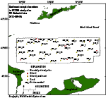
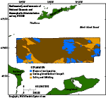
SedimentsSediment Distribution Sediment samples from the sea floor in the study area are composed of sand, gravelly sediment, and gravel (fig. 22). Sand, often in the form of sand waves and megaripples, covers much of the sea floor. Sand in deep areas is generally finer grained than in shallow or constricted areas. Gravel is mostly on bathymetric highs, in areas where deposits associated with recessional ice-front positions, end moraines, and coastal-plain sediments covered with basal till are exposed (Needell and Lewis, 1984). Gravel is also found along the eastern wall of the current-scoured bathymetric depression, where fine sediments have been winnowed away, leaving behind a coarse lag. Mud (silt and clay) is not prominent on the sea floor in the study area; samples at each station contained less than 25 percent mud, and most contained less than 5 percent. Sedimentary EnvironmentsThe distribution of sea-floor features and verification data indicate that the delineated sedimentary environments in the study area are primarily controlled by strong tidal currents and are characterized by processes associated with erosion or nondeposition, coarse-grained bedload transport, and sorting and reworking (fig. 23). Boulders and gravel are often an indication of sedimentary environments characterized by erosion or nondeposition. In these high-energy environments, which are common on bathymetric highs in the study area, fine-grained sediment is winnowed away, leaving a coarse-grained lag. Sedimentary environments of erosion or nondeposition are also present in the northwestern corner of the study area, where once-buried glaciolacustrine sediments have been exposed, and along the gravelly eastern side of the current-scoured depression. Bedforms are a prominent feature of sedimentary environments characterized by coarse-grained bedload transport, in which sand and pea gravel are moved by bottom currents. This sedimentary environment comprises about 70 percent of the sea floor in the study area. Sedimentary environments characterized by processes of sorting and reworking are found where relatively flat-lying modern marine sediments cover the sea floor. The absence of mud in the sampled sediments reflects the absence of sedimentary environments characterized by fine-grained deposition in the study area. Sediment Data The sediment grain-size dataset provided in this report contains information on the collection, description, and texture of sediments at the 37 stations in the study area. However, the sea floor was sampled at only 28 of the stations, because at the others either coarse-grained sediment or a rough sea state prevented samples from being obtained. Stations where samples could not be obtained were visually classified on the basis of video and still photography obtained at the station. These stations have no-data values (-9999) in the textural and statistical sections of the sediment dataset. The basic structure of the dataset is a matrix in which rows represent individual samples and columns (fields) contain sample- and station-specific information. This matrix consists of 42 fields that are defined in the Data Dictionary below. Data DictionaryAn integral part of any database is the dictionary that explains the structure and content. This compilation facilitates data use by listing fields and defining parameters measured. LABNO - Unique sample identifier assigned in the laboratory STATIONID - Sample name or number assigned in the field PROJECT - Project under which samples were taken or data were generated CRUISEID - Name or number of cruise on which the sample was collected or station was occupied PRINCIPAL - Name of the principal investigator LATITUDE - Latitude in decimal degrees (north latitudes are positive values) LONGITUDE - Longitude in decimal degrees (west longitudes are negative values) DEPTH_M - Depth of water overlying sediment at the time of sampling, measured by a hull-mounted fathometer, corrected for draft, but not corrected for tides, in meters T_DEPTH - Top depth of the sample below the sediment-water interface, in centimeters B_DEPTH - Bottom depth of the sample below the sediment-water interface, in centimeters DEVICE - Device used to collect the sample MONTH - Number of calendar month during which the sample was collected DAY - Calendar day on which the sample was collected YEAR - Calendar year during which the sample was collected WEIGHT - Dry weight of sample, in grams ZGRAVEL - Gravel content in percent dry weight of the sample (particles with nominal diameters greater than 2 mm; -1 phi and larger) ZSAND - Sand content in percent dry weight of the sample (particles with nominal diameters less than 2 mm but greater than or equal to 0.0625 mm; 0 through 4 phi, inclusive) ZSILT - Silt content in percent dry weight of the sample (particles with nominal diameters less than 0.0625 mm but greater than or equal to 0.004 mm; 5 through 8 phi, inclusive) ZCLAY - Clay content in percent dry weight of the sample (particles with nominal diameters less than 0.004 mm; 9 phi and smaller) SEDCLASS - Sediment description based on a rigorous definition (Shepard, 1954; Schlee, 1973; Poppe and others, 2004)
MEDIAN - Middle point in the grain-size distribution, in phi units MEAN - Average value in the grain-size distribution, in phi units STDDEV - Standard deviation (root mean square of the deviations) of the grain-size distribution, in phi units (that is, sorting) SKEWNESS - Deviation from symmetrical form of the grain-size distribution KURTOSIS - Degree of curvature near the mode of the grain-size distribution PHI_11 - Weight percent of the sample in the 11-phi fraction (nominal diameter of particles greater than or equal to 0.0005 mm but less than 0.001 mm); fine clay PHI_10 - Weight percent of the sample in the 10-phi fraction (nominal diameter of particles greater than or equal to 0.001 mm but less than 0.002 mm); medium clay PHI_9 - Weight percent of the sample in the 9-phi fraction (nominal diameter of particles greater than or equal to 0.002 mm but less than 0.004 mm); coarse clay PHI_8 - Weight percent of the sample in the 8-phi fraction (nominal diameter of particles greater than or equal to 0.004 mm but less than 0.008 mm); very fine silt PHI_7 - Weight percent of the sample in the 7-phi fraction (nominal diameter of particles greater than or equal to 0.008 mm but less than 0.016 mm); fine silt PHI_6 - Weight percent of the sample in the 6-phi fraction (nominal diameter of particles greater than or equal to 0.016 mm but less than 0.031 mm); medium silt PHI_5 - Weight percent of the sample in the 5-phi fraction (nominal diameter of particles greater than or equal to 0.031 mm but less than 0.0625 mm); coarse silt PHI_4 - Weight percent of the sample in the 4-phi fraction (nominal diameter of particles greater than or equal to 0.0625 mm but less than 0.125 mm); very fine sand PHI_3 - Weight percent of the sample in the 3-phi fraction (nominal diameter of particles greater than or equal to 0.125 mm but less than 0.25 mm); fine sand PHI_2 - Weight percent of the sample in the 2-phi fraction (nominal diameter of particles greater than or equal to 0.25 mm but less than 0.5 mm); medium sand PHI_1 - Weight percent of the sample in the 1-phi fraction (nominal diameter of particles greater than or equal to 0.5 mm but less than 1 mm); coarse sand PHI_0 - Weight percent of the sample in the 0-phi fraction (nominal diameter of particles greater than or equal to 1 mm but less than 2 mm); very coarse sand PHIM1 - Weight percent of the sample in the -1-phi fraction (nominal diameter of particles greater than or equal to 2 mm but less than 4 mm); very fine pebbles (granules) PHIM2 - Weight percent of the sample in the -2-phi fraction (nominal diameter of particles greater than or equal to 4 mm but less than 8 mm); fine pebbles PHIM3 - Weight percent of the sample in the -3-phi fraction (nominal diameter of particles greater than or equal to 8 mm but less than 16 mm); medium pebbles PHIM4 - Weight percent of the sample in the -4-phi fraction (nominal diameter of particles greater than or equal to 16 mm but less than 32 mm); coarse pebbles PHIM5 - Weight percent of the sample in the -5-phi fraction (nominal diameter of particles greater than or equal to 32 mm); very coarse pebbles to boulders |

![]() U.S. Department of the Interior |
U.S. Geological Survey
U.S. Department of the Interior |
U.S. Geological Survey
URL: http://pubsdata.usgs.gov/pubs/of/2014/1160/html/ofr2014-1160-seds.html
Page Contact Information: GS Pubs Web Contact
Page Last Modified: Wednesday, 07-Dec-2016 19:37:57 EST