Open-File Report 2014-1220
Shallow Geology, Sea-Floor Texture, and Physiographic Zones of Buzzards Bay, Massachusetts
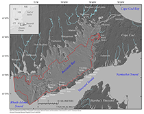
The geologic framework and seabed character of the Massachusetts coastal ocean is complex and difficult to map. Previous studies have defined the geology and texture of the sea floor in the Buzzards Bay area on the basis of widely spaced geophysical tracklines and vibracores (Robb and Oldale, 1977; O’Hara and Oldale, 1980) or sediment samples (Hough, 1940; Moore, 1963; Ford and Voss, 2010). Mapping methods for homogenous, nonglaciated regions rely on the contouring changes in grain size (Hollister, 1973), but the substrate variations over short distances in the Buzzards Bay area, common in previously glaciated regions, occur over spatial scales that are typically smaller than a sampling grid can resolve. A study by the U.S. Geological Survey (USGS), in cooperation with the Massachusetts Office of Coastal Zone Management (CZM), provided high-resolution geophysical datasets with full sea-floor coverage, supplemented with sediment samples and bottom photographs. These datasets provide the source for surficial to shallow subsurface geologic maps, high-resolution sediment texture maps, and physiographic zone delineations that were previously unfeasible because of a lack of high-quality, high-density sea-floor mapping data. Purpose and ScopeThe purpose of this report describes the geologic framework and sea-floor character of Buzzards Bay (fig. 1). Interpretive maps of the shallow stratigraphy, surficial geology, surficial sediment texture, and physiographic zones are presented. The geologic interpretations in this report are based on several geophysical surveys (table 1), on bottom photographs (Ackerman and others, 2014), and on sediment sample databases (Ford and Voss, 2010; McMullen and others, 2011) edited by the Massachusetts Office of Coastal Zone Management (written comunn., 2012). Interpretations and associated data are provided as geospatial data layers in Esri ArcGIS formats (Appendix —Geospatial Data). This research was conducted as part of a cooperative program of the USGS and CZM. This cooperative mapping program provides interpretive geologic datasets that can be used by managers and scientists to delineate marine resources, assess environmental change, inventory marine habitats, and support research concerning sea-level change, sediment supply, and coastal evolution. Detailed information and mapping products related to this cooperative program can be accessed at http://woodshole.er.usgs.gov/project-pages/coastal_mass/. Geographic SettingBuzzards Bay is an embayment in southeastern Massachusetts (fig. 1). Buzzards Bay has mean water depths of 5 to 10 meters (m) near the bay head and 20 m near the bay mouth (Signell, 1987). The south coast of mainland Massachusetts (the irregular coast extending from Westport to Wareham), the west coast of Cape Cod, and the Elizabeth Islands partially enclose the bay. The mouth of the bay opens to Rhode Island Sound and connects with Vineyard Sound through narrow straits between the Elizabeth Islands. The Cape Cod Canal, excavated in 1914 along the Manomet River valley, connects the head of Buzzards Bay with Cape Cod Bay. Several rivers enter elongated coastal embayments (drowned valleys) along the western margin of Buzzards Bay between the Cape Cod Canal and the Rhode Island border. In contrast, the Buzzards Bay moraine makes topography in western Cape Cod relatively steep, resulting in a coastal landscape with limited drainage area along the eastern border of Buzzards Bay. Consequently, the coast does not have drowned river estuaries and coastal embayments are relatively small. Geologic FrameworkProterozoic bedrock surrounds and is inferred to underlie the entire Buzzards Bay basin (Zen and others, 1983). Cretaceous and early Tertiary strata (coastal plain deposits) are known to be present southeast of the Elizabeth Islands beneath Vineyard Sound but not beneath Buzzards Bay, where they are suspected to have been eroded during the late Tertiary by fluvial processes and Pleistocene glaciation (O’Hara and Oldale, 1980). Subaerial erosion of the bedrock surface established a southward- to southeastward-flowing drainage surface, which is expressed in the present ridge and valley topography of the south coast of mainland Massachusetts (FitzGerald and others, 1987). The depth to the bedrock surface varies from 0 to 25 meters below sea level (mbsl) along the northwest shore to the head of the bay and increases to the east: about 65 mbsl near the center of the bay (Brocher and Ewing, 1986), between 45 and 85 mbsl near the east shore of the Bay along Cape Cod (Fairchild and others, 2013), and about 100 mbsl along the southeast shore of the bay along the Elizabeth Islands (Oldale, 1969). Several geologists have mapped the onshore surficial geology surrounding Buzzards Bay in detail, and their findings have been compiled on maps by Stone and DiGiacomo-Cohen (2009) and Stone and others (2011). Geologic units define surficial boundaries between bedrock, glacial till, glacial moraine, coarse- and fine-grained glacial stratified deposits, and postglacial deposits. Glacial stratified deposits are further divided into glaciofluvial, glaciodeltaic, and glaciolacustrine deposits. These glacial meltwater sediments were deposited within glacial lakes and outwash systems that grade from ice-proximal to ice-distal facies. Along the northwest shore of Buzzards Bay, till and underlying bedrock form a series of ridges and headlands. Stratified drift of glaciofluvial and glaciolacustrine origin partially fills the valleys between them (FitzGerald and others, 1987; Bent, 1995; Stone and others, 2011). Beneath Buzzards Bay, Robb and Oldale (1977) mapped bedrock, glacial drift (including till, moraine, ice-contact, and outwash deposits), transitional deposits (including glaciofluvial, estuarine and nearshore deposits related to the Holocene transgression), and recent marine deposits. Stratigraphic units mapped in eastern Rhode Island Sound by O’Hara and Oldale (1980) include Paleozoic bedrock, coastal plain deposits, Buzzards Bay moraine deposits, and glacial drift (including ice-contact stratified drift, outwash plain, and glaciolacustrine deposits). A regressive unconformity was identified at the base of postglacial fluvial and estuarine deposits, and a marine transgressive unconformity was identified at the base of marine beach and bar deposits and recent quiet-water marine deposits. Depositional HistoryThe geology of Buzzards Bay basin is broadly defined by the underlying bedrock structure and glacial processes related to late Pleistocene glacial advance (marine isotope stage 2). Glacial moraines (fig. 2) and drift were deposited by the Buzzards Bay lobe of the Wisconsinan Laurentide ice sheet, which reached its maximum extent at Martha’s Vineyard, forming a terminal moraine between 25.5 and 28 thousand years (ka) before present (BP) (Uchupi and others, 1996; Oldale, 2001; Balco and others, 2002; Boothroyd and Sirkin, 2002; Balco, 2011). The Buzzards Bay lobe retreated and readvanced, forming the Buzzards Bay moraine between 20.5 and 22.5 ka BP (Balco, 2011); the moraine shapes the Elizabeth Islands and much of the west coast of Cape Cod (Mather and others, 1942; Oldale and O’Hara, 1984). With the retreat of the Buzzards Bay lobe, outwash, derived from a readvance of the Cape Cod Bay lobe, was deposited between the Buzzards Bay lobe and the Buzzards Bay moraine along the west coast of Cape Cod (Oldale, 1976; Larson, 1982). With continued retreat of the ice front, glacial till and stratified drift were deposited in what is now Buzzards Bay (Robb and Oldale, 1977). When the Buzzards Bay lobe retreated northward, the Wareham pitted plain was deposited along the northeast shore at the head of Buzzards Bay (Larson, 1982). These outwash valleys and drainage of Glacial Lake Cape Cod (which formed in the present location of Cape Cod Bay, north of the Sandwich moraine, as the Cape Cod Bay lobe retreated) through the Monument (Manomet) Valley outlet (Woodworth and Wigglesworth, 1934) contributed to the establishing of drainage patterns within the Buzzards Bay basin. The character of the sea floor and shallow subsurface was strongly influenced by glaciofluvial and fluvial erosion during the last sea-level lowstand and by processes associated with subsequent Holocene sea-level rise and inundation. Postglacial fluvial systems also incised a drainage network into the subaerially exposed glacial drift of the Buzzards Bay basin, and fluvial modification of the drainage basin continued until approximately 8000 years BP, when sea level began to transgress the glacial, glaciofluvial, and estuarine deposits (Robb and Oldale, 1977; O’Hara and Oldale, 1980). Subsequently, marine sediments filled or partially filled fluvial and estuarine tidal channels primarily in the deeper areas of the basin. The postglacial paleodrainage is partially expressed in the bathymetry of the bay, particularly in the southwest segment of the study area (Hough, 1940; Moore, 1963; Robb and Oldale, 1977). Previous Geologic and Sediment MappingRobb and Oldale (1977) completed the only geologic mapping study of Buzzards Bay, and O’Hara and Oldale’s (1980) maps of Eastern Rhode Island Sound extend to the mouth of Buzzards Bay. These studies collected widely spaced (approximately 2000 m apart) boomer seismic-reflection profiles and provided a broad stratigraphic framework and general surficial geologic mapping of Buzzards Bay. Both studies incorporated limited vibracore collection and analysis. These previous studies produced a series of structure and isopach maps along with surficial geologic maps. Previously published sea-floor sediment texture maps of Buzzards Bay are based on sediment sample data only (Hough, 1940; Moore, 1963). Although these studies provide a general picture of sediment distribution in the bay, the spacing of the sampling grid limits their use in resolving spatial changes. Poppe and others (2007, 2008) mapped sea-floor character in detail in the vicinity of Quicks Hole and Woods Hole on the basis of interpretation from acoustic backscatter, multibeam bathymetry, seismic-reflection profiles, surficial sediment samples, and bottom photographs. Ford and Voss (2010) recently compiled a database consisting of grab sample, video, and photographic data for Massachusetts state waters, which includes Buzzards Bay. Ford and Voss (2010) evaluated their compiled datasets for data quality and generated sea-floor sediment texture maps by using gridding and Thiessen polygon analysis.
|

![]() U.S. Department of the Interior |
U.S. Geological Survey
U.S. Department of the Interior |
U.S. Geological Survey
URL: http://pubsdata.usgs.gov/pubs/of/2014/1220/ofr2014-1220-introduction.html
Page Contact Information: GS Pubs Web Contact
Page Last Modified: Wednesday, 07-Dec-2016 20:04:04 EST