Open-File Report 2014-1220
Shallow Geology, Sea-Floor Texture, and Physiographic Zones of Buzzards Bay, Massachusetts
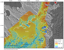
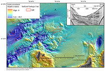
Each stratigraphic unit (fig. 9) crops out at the sea floor in the study area (fig. 16), and the areal distributions of the units are closely related to surficial sediment distributions (fig. 17) and physiographic zone (fig. 19) interpretations. Surficial geologic units may not directly correspond with surficial sediment units because geologic units may be buried beneath surficial sediments too thin to be detected in the seismic data (less than about 0.5 m). Outcrops of Z are most extensive along the northwest shore of Buzzards Bay, between Westport and Fairhaven. The outcrops, where visible on aerial photographs, are shown on the sediment-type map (fig. 17). These outcrop locations were plotted as symbols on the surficial geologic map (fig. 16); however, they are outside of the area of the geologic map and are not included in the geospatial data. Elsewhere in the basin, bedrock is buried by Quaternary sediment. Bedrock highs, approximately 45 mbsl beneath western Cape Cod, coincide with the Buzzards Bay moraine (Fairchild and others, 2013). Bedrock is substantially deeper, approximately 100 mbsl, beneath the Elizabeth Islands portion of the Buzzards Bay moraine (Oldale, 1969). Polygons representing Z are included in the sediment-type map (fig. 16) and were mapped as R. The surficial distribution of Z corresponds to Rocky Zones where the sediment texture is R (fig. 19). Qdt crops out throughout Buzzards Bay but is most prevalent along the margins of the bay and along a series of bathymetric ridges extending from Penikese Island across the mouth of the bay to Westport (fig. 16). Pinnacles and ledges of Qdt that are mostly buried by younger sediment are exposed in the remainder of the bay. The dominant surficial sediment textures associated with Qdt include all composite units within the primary unit R, the primary unit G, and the composit units Gs and Sg; these sediment types make up most of the Rocky Zones on the physiographic zone mapping (fig. 19). Qdm crops out along the Elizabeth Islands in association with the Buzzards Bay moraine (fig. 16). Surficial sediment textures Rg, Rs, G, Gs, and Sr, which typically include concentrations of boulder-sized lag deposits, most notably proximate to Cuttyhunk Island. Like Qdt, Qdm is associated with Rocky Zones. Qdl is typically buried by younger deposits but crops out at the sea floor where overlying deposits have been eroded (fig. 16). One such area is a depression just north of Quicks Hole. Other exposures are within the deep channels between Cuttyhunk Island and the mainland. These deposits are generally associated with Sm sediment type, although Sg, sand with a gravel lag can be present where Qdl has been eroded, which is confirmed from sediment samples and bottom photographs in the depression near Quicks Hole. Qdl exposures do not exhibit positive relief and are generally included in the Nearshore Basin zones. Qdf crops out over much of the sea floor where it is not buried by postglacial deposits Qfe/Qmn (fig. 16). Qdf often is found adjacent to outcrops of Qdt. Outcrops of Qdf have positive relief related to glacial outwash and fan-delta features. The dominant sediment types include G, Gs, Sg, and S, which are associated physiographic zones mapped as Hard-Bottom Plains (fig. 19). When associated with Nearshore Basin zones, Qdf includes sediment-type Sm. Qfe and Qmn are undifferentiated in the surficial mapping, although Qmn typically covers Qfe and limits exposure of Qfe at the sea floor (fig. 16). Predominant sediment types include Ms, Sm, and S. Sandier sediment is associated with Qfe/Qmn close to shore and close to outcrops of glacial drift where coarse sediment has been reworked and mixed with fine-grained sediment. Sandier sediment is also associated with places where Qmn forms shoals and beaches from modern shorelines and paleoshorelines. Qfe/Qmn is associated with Nearshore Basin zones and to a lesser extent Nearshore Ramp (fig. 19). Geologic FrameworkInterpretation of the geologic framework and seismic stratigraphy of Buzzards Bay was fundamental in developing a foundation for the surficial mapping. Our interpretation of the geologic framework is compatible with those of Robb and Oldale (1977) and O’Hara and Oldale (1980) (fig. 9). The geologic framework is a product of the glacial deposition resulting from stepwise retreat of the late Wisconsinan glacier across the basin and finally by the Holocene marine transgression. Morphosequence mapping, a method commonly used on land (Koteff, 1974; Koteff and Pessl, 1981; Randall, 2001; Stone and DiGiacomo-Cohen, 2009; Stone and others 2011), can be applied to mapping the now submerged stratified glacial deposits of Buzzards Bay. In summary, morphosequences formed with ice retreat where the ice margin stayed in the same location long enough for sediments to partially fill or completely fill a proglacial lake. The level of the proglacial lake controlled the base level in which stratified drift was deposited. A spillway may have controlled the proglacial lake level. Poorly sorted, coarse-grained facies are characteristic proximal to the ice margin and grade into fine-grained deltaic sand and gravel away from the ice margin. These deltaic sediments commonly prograde over lake-bottom fine sand, silt and clay. The resulting stratified-drift deposit comprises a single, approximately time-equivalent morphosequence. Stepwise ice retreat across the Buzzards Bay basin resulted in the formation of morphosequences and the development of a meltwater drainage network (fig. 14). The formation of the two channels (figs. 3 and 14) observed near the mouth of the bay can be explained by a succession of channels opening with retreat of the ice margin. A prime example of a well-preserved morphosequence in Buzzards Bay is an ice-proximal fan delta filled a proglacial lake in northern Buzzards Bay (fig. 21). The Holocene marine transgression flooded the postglacial drainage surface (Ur) of Buzzards Bay, and fluvial deposition changed to estuarine deposition in the valleys. In much of the Buzzards Bay basin, estuarine and nearshore marine (postglacial) deposits filled or partially filled fluvial valleys. These valleys are still partially expressed in the bathymetry (Hough, 1940; Moore, 1963; Robb and Oldale, 1977). Erosion of postglacial deposits from wave and tidal currents may have resulted in the truncation of postglacial deposits or exposure of glaciolacustrine deposits, most notably where a scour depression exposes stratified glacial deposits just north of Quicks Hole (fig. 22).
|

![]() U.S. Department of the Interior |
U.S. Geological Survey
U.S. Department of the Interior |
U.S. Geological Survey
URL: http://pubsdata.usgs.gov/pubs/of/2014/1220/ofr2014-1220-discussion.html
Page Contact Information: GS Pubs Web Contact
Page Last Modified: Wednesday, 07-Dec-2016 20:04:47 EST