Open-File Report 2014-1227
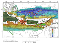
IntroductionAnalysis of the bathymetry of the submerged carbonate platform north of Puerto Rico has identified numerous submarine landslides that range in size from 0.009 to 28.5 cubic kilometers (km3; ten Brink, Geist, Lynett, and Andrews, 2006). These landslides, along with regional earthquakes, are thought to have potentially caused tsunamis that devastated the coastal communities of Puerto Rico and the U.S. Virgin Islands (López-Venegas and others, 2008). Eight landslides in this area were of sufficient size to cause damaging tsunamis (ten Brink, Geist, and Andrews, 2006); however, the dates the landslides and earthquakes that occurred before the historical record are unknown. In an effort to establish temporal data for past tsunamigenic landslide and earthquake events, the U.S. Geological Survey (USGS), in cooperation with Woods Hole Oceanographic Institution (WHOI), deployed the research vessel (RV) Seward Johnson on cruise 2008–008–FA (henceforth referred to as SJ8) to collect sediment cores from offshore Puerto Rico (in Mona Canyon and along the south wall of and within the Puerto Rico Trench) and the Virgin Islands (Virgin Islands and Whiting Basins) (fig. 1; Chaytor and ten Brink, 2014; Chaytor and ten Brink, 2014a,b). Sampling at 40 sites was attempted during cruise SJ8 by using the WHOI giant gravity corer; however, because of dense mud or coarse sediment at some sites and (or) mechanical issues, only 20 cores were recovered, with sediment in only the core catcher or cutting head collected at an additional 7 sites (fig. 1). Eleven cores archived at Lamont-Doherty Earth Observatory (LDEO) supplement the data collected from the SJ8 cores.The purpose of this report is to release data collected from 31 cores (20 from SJ8 and 11 archived cores). The SJ8 gravity cores were sampled for grain-size (textural) analyses and radiocarbon dating, they underwent nondestructive testing, including measurements of wet-bulk density, magnetic susceptibility, and x-ray fluorescence (XRF) scanning, and they were x-radiographed. Accelerator mass spectrometry (AMS) carbon-14 radiocarbon age dates were determined for eight of the SJ8 cores and all the LDEO archive cores (19 in total) in order to constrain the timing of landslides and earthquakes around Puerto Rico and the Virgin Islands.
|

![]() U.S. Department of the Interior |
U.S. Geological Survey
U.S. Department of the Interior |
U.S. Geological Survey
URL: http://pubsdata.usgs.gov/pubs/of/2014/1227/ofr2014-1227-introduction.html
Page Contact Information: GS Pubs Web Contact
Page Last Modified: Wednesday, 07-Dec-2016 19:40:57 EST