Open-File Report 2014–1238
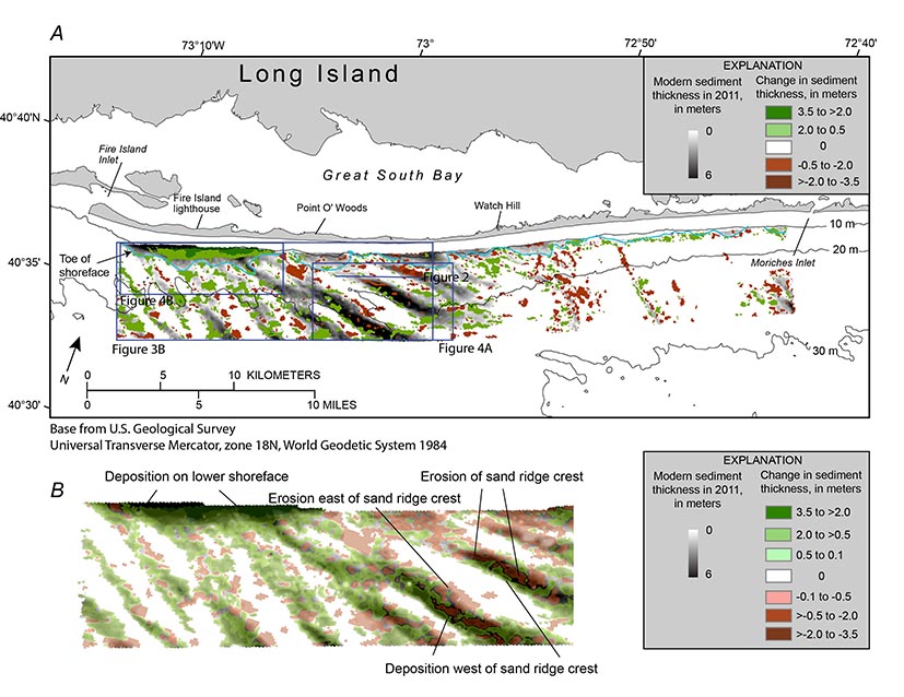
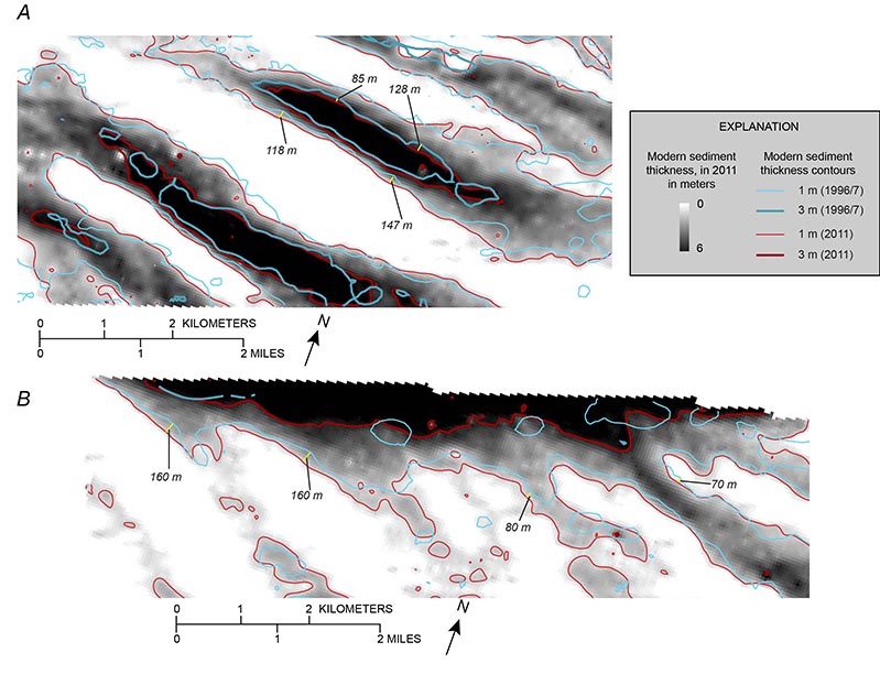
Mapping ResultsPrevious interpretations of marine geologic mapping data support the hypothesis that the Holocene evolution of Fire Island, including its modern decadal to centennial behavior, is linked directly to the geologic framework of the inner continental shelf. Schwab, Thieler, Denny, and others (2000) and Schwab and others (2013) identified the modern sediment deposit on the inner continental shelf offshore of Fire Island as a likely source of sediment required to balance the coastal sediment budget, suggesting that an onshore-directed component of the dominant westerly sediment flux (from the inner continental shelf to the shoreface), in combination with periodic contribution from beach nourishment activities, provides sufficient sediment to maintain island stability west of Watch Hill. A comparison of modern sediment thickness mapped from seismic-reflection data in 1996–97 (Foster and others, 1999; Schwab, Thieler, Allen, and others, 2000) and 2011 (Schwab, Denny, and Baldwin, 2014) provides evidence to support the hypothesis of shoreward-directed sediment flux. The comparison (figs. 3 and 4 ), which shows changes in sediment thickness greater than 50 cm (the vertical resolution limit of the subbottom systems used in the two surveys), illustrates net westerly migration of the sand ridges, with erosion on their eastern flanks and crests and deposition on their western flanks, as well as significant accretion along the lower shoreface of western Fire Island. Schwab and others (2014) calculated that the modern sediment volume on the lower shoreface has accreted 7.8 × 10⁶ cubic meters (m3) and the modern sand deposit on the inner continental shelf was reduced by 3.1 × 10⁶ m3 over the 15-year period. This led them to speculate that the lower shoreface modern sediment deposit has gained volume at the expense of deflation of the large shoreface-attached sand ridges and inner continental shelf in general. This raises a question: if the shoreface-attached sand ridges are eroding, how are these prominent features maintained in the long term? While attempting to address this question, an error was discovered in the volumetric calculations presented in Schwab, Baldwin, Denny, and others (2014); they did not convert the modern sediment thickness isopach of the 1996–97 survey produced by Foster and others (1999) to the common velocity of 1,500 m/s prior to comparing to the 2011 data (Schwab, Denny, and Baldwin, 2014). Although seemingly a minor correction (see “Data Collection and Processing” section above), following conversion the modern sediment volume of the lower shoreface is shown to have increased on the lower shoreface by 10.2 × 10⁶ m3 and increased on the inner continental shelf by 10.0 × 10⁶ m3 over the 15-year timespan; total accretion of 20.2 × 10⁶ m3. This calculation includes the mining of 2.4 × 10⁶ m3 of sand for beach nourishment activities (Lentz and others, 2013). Thus, speculation by Schwab, Baldwin, Denny, and others (2014) that the lower shoreface has gained volume at the expense of deflation of the shoreface-attached sand ridges is incorrect. Modern sediment thicknesses greater than 50 cm were mapped over 112 km2 in the 1996–97 surveys (41 percent of the mapped area) and over 119 km2 of the 2011 survey (43 percent of the mapped area). The mean change in modern sediment thickness for the mapped area is +0.07 m, with the mean gain in areas of accretion +0.56 m and mean loss in areas of erosion -0.14 m. This strongly implies that erosion of Pleistocene glaciofluvial and lower Holocene channel-fill deposits exposed at the seafloor continues to yield the modern sediment required to balance the coastal sediment budget (Schwab and others, 2013) and maintain the shoreface-attached sand ridges. |

![]() U.S. Department of the Interior |
U.S. Geological Survey
U.S. Department of the Interior |
U.S. Geological Survey
URL: http://pubsdata.usgs.gov/pubs/of/2014/1238/ofr2014-1238-mappingresults.html
Page Contact Information: GS Pubs Web Contact
Page Last Modified: Wednesday, 07-Dec-2016 20:05:10 EST