Skip past header information
USGS - science for a changing world

Open-File Report 2014–1238
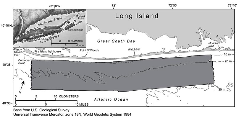
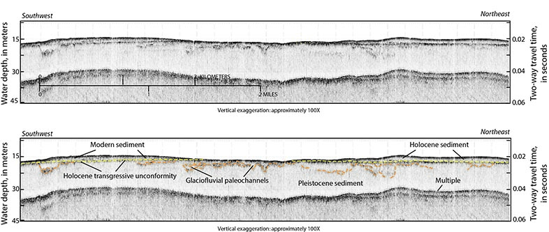
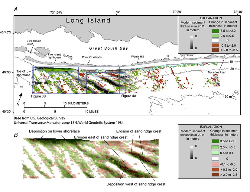

Maps Showing the Change in Modern Sediment Thickness on the Inner Continental Shelf Offshore of Fire Island, New York, Between 1996–97 and 2011


Skip past contents information
Map showing the survey area offshore of Fire Island, New York, 2011.

Figure 1. Map showing the survey area (shaded in dark gray) offshore of Fire Island, New York, 2011. Inset map shows location of study area (outlined in black). Bathymetric contours are in meters (m) below the North American Vertical Datum of 1988 (NAVD 88). Figure modified from Schwab and others (2013).

High-resolution chirp seismic-reflection proflie showing stratigraphic features and geometries discussed in the text, offshore of Fire Island, New York.

Figure 2. High-resolution chirp seismic-reflection profile and interpretation illustrating stratigraphic features and geometries discussed in the text. Location of the profile is shown in figure 3. Approximate water depth in meters is based on a two-way travel time of 1,500 meters per second. The Holocene transgressive unconformity is marked by a yellow dashed line. Glaciofluvial channels and older Pleistocene sediments are marked by orange dashed lines. Figure modified from Schwab and others (2013).

Map showing the change in modern sediment thickness greater tahn 0.5 meters between 1996-7 and 2011 isopachs offshore of Fire Island, New York..

Figure 3. A, Map showing the change in modern sediment thickness greater than 0.5 meter (m) between isopachs interpreted from 1996–97 (Foster and others, 1999) and 2011 (Schwab, Denny, and Baldwin, 2014) seismic-reflection data, overlain on the 2011 modern sediment thickness isopach (Schwab, Denny, and Baldwin, 2014), offshore of Fire Island, New York. Blue line shows seaward extent (toe) of the shoreface (Schwab, Baldwin, Denny, and others, 2014). Regional bathymetric contours are in meters below the North American Vertical Datum of 1988 (NAVD 88). Figure modified from Schwab, Baldwin, Denny, and others (2014). B, Enlargement of area shown in A. Change in sediment thickness shown by using a less conservative vertical resolution limit of 10 centimeters to illustrate net westerly migration of the sand ridges, with erosion on the eastern flanks and crests of the ridges and deposition on the western flanks.

Regional Geologic Setting

Long Island marks the southern terminus of the Wisconsinan Laurentide glacial advance in the eastern part of North America (Stone and Borns, 1986). The coast from Southampton to Montauk Point is a headland region where the Ronkonkoma moraine (fig. 1) and associated glacial outwash sediment are eroded directly by wave action (Williams, 1976). The south shore of Long Island west of Southampton consists of reworked outwash and includes shallow back-barrier bays, marshes, and low-relief, sandy barrier islands (Leatherman and Allen, 1985). Located within this barrier-island system is Fire Island, a 0.5- to 1.0-kilometer (km)-wide, 50-km-long barrier island that is bound by two tidal inlets, Moriches Inlet to the east and Fire Island Inlet to the west (fig. 1).

Pleistocene glaciofluvial outwash deposits are exposed over much of the inner continental shelf south of Fire Island. The upper surface of the Pleistocene deposits was incised by a series of paleochannels that were subsequently filled with a transgressive sequence of glaciofluvial sediment, in places capped by lower Holocene muddy estuarine sediment (fig. 2). The modern sand deposit is derived from erosion of these Pleistocene glaciofluvial and lower Holocene fluvial channel-fill deposits exposed on the inner continental shelf by oceanographic processes during the Holocene marine transgression. The distribution of the modern sand deposit is discontinuous and variably thick, and it lies unconformably atop the Pleistocene and lower Holocene deposits (figs. 2 and 3). This unconformity is interpreted to be the Holocene transgressive surface. For a full review of the major inner continental shelf sedimentary sequences offshore of New York, see Schwab, Baldwin, Denny, and others (2014) and Schwab, Denny, and Baldwin (2014) and references therein.

Accessibility FOIA Privacy Policies and Notices

Take Pride in America logo USA.gov logo U.S. Department of the Interior | U.S. Geological Survey
URL: http://pubsdata.usgs.gov/pubs/of/2014/1238/ofr2014-1238-geologic_setting.html
Page Contact Information: GS Pubs Web Contact
Page Last Modified: Wednesday, 07-Dec-2016 20:05:09 EST