Open-File Report 2014-1246
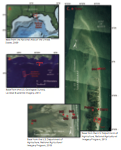
IntroductionThe U.S. Geological Survey (USGS) measured atmospheric pressure, water levels, and waves in the barrier island system of the Chandeleur Islands, Louisiana, during 2012 and 2013 as part of the Barrier Island Evolution Research (BIER) project. Barrier islands are dynamic systems that can experience substantial morphological change (erosion and deposition) during storms. Water levels around barrier islands are influenced by winds, waves, and atmospheric pressure during the passage of storms, and the morphological effect of storms depends, in part, on the magnitude of inundation and water-level gradients across the island. Direct water-level measurements on barrier islands during storms are somewhat uncommon because equipment is often lost, buried, or destroyed during these high-energy events. This report describes the instrumentation, field methods, and data processing techniques used to measure water levels and waves with relatively inexpensive pressure sensors in a rapidly evolving barrier island system (fig. 1). These water-level and wave measurements can be used to validate numerical models and to help interpret the morphological response of the islands to storms.
|

![]() U.S. Department of the Interior |
U.S. Geological Survey
U.S. Department of the Interior |
U.S. Geological Survey
URL: http://pubsdata.usgs.gov/pubs/of/2014/1246/ofr2014-1246-introduction.html
Page Contact Information: GS Pubs Web Contact
Page Last Modified: Wednesday, 07-Dec-2016 20:06:08 EST