Open-File Report 20151055
Effects of Proposed Sediment Borrow Pits on Nearshore Wave Climate and Longshore Sediment Transport Rate Along Breton Island, Louisiana
Citation | List of Figures | List of Tables | Conversion Factors | Abbreviations | Abstract | Introduction | Methods | Results | Conclusions | Acknowledgments | References Cited | Appendix 1. Scenarios | Appendix 2. Example Model Input Files | Appendix 3. File Naming Conventions | Digital Data Files
 |
||
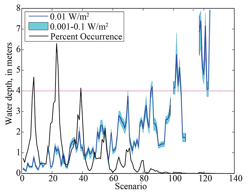
| Figure 5. Depth at which depth-induced wave breaking dissipation (output from SWAN) exceeded 0.01 watt per square meter (W/m2) (dark blue line) at 95 percent of alongshore locations for each wave scenario. Also shown are the depth at which breaking dissipation exceeded 0.001 W/m2 and 0.1 W/m2 (light blue band) and the percentage occurrence (black line) for each scenario. The island platform was defined as the 4 m contour (in pink; fig. 4), and in cases where the threshold of breaking dissipation was exceeded at deeper than 4 m, values from this depth were used in calculating alongshore flux. | ||

![]() U.S. Department of the Interior |
U.S. Geological Survey
U.S. Department of the Interior |
U.S. Geological Survey
URL: http://pubsdata.usgs.gov/pubs/of/2015/1055/ofr2015-1055_figure5.html
Page Contact Information: GS Pubs Web Contact
Page Last Modified: Monday, 28-Aug-2017 17:30:44 EDT
