Open-File Report 20151055
 |
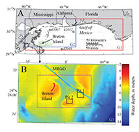
North Breton Island, located at the southern end of the Chandeleur Islands, Louisiana, and part of the Breton National Wildlife Refuge (BNWR), provides important habitat for nesting colonies of brown pelicans. Loss of subaerial island extent can affect this species through reduction of nesting area. Due to storm impacts, relative sea level rise, and diminished sediment supply from dredging of the Mississippi River Gulf Outlet (MRGO), island area has been reduced by 93 percent since the 1920s (Martinez and others, 2009). In an effort to preserve Breton Island (fig. 1), the southernmost extent of the BNWR, the U.S. Fish and Wildlife Service (FWS) plans to nourish the island by restoring island elevation using nearby offshore sand resources. FWS requested that the U.S. Geological Survey (USGS) evaluate the potential effects of mining offshore sand on the wave climate and longshore sediment transport at Breton Islands; results of that evaluation are presented in this report. Studies have shown that sediment deposits within BNWR suitable for shoreline nourishment are rare (Twichell and others, 2009) and are confined to buried distributary channels, terminal spits, and tidal deposits (Flocks and others, 2009). Analyzing the seafloor morphology offshore of Breton Island, potential relict spit and tidal deposits have been identified in approximately 3–6 m of water. Dredging borrow pits in these deposits will change the seafloor morphology, which could alter the wave transformation and result in changes in the wave climate locally and around the island. If effects on the wave climate extend to nearshore regions around the island, the breaking wave characteristics (significant height and peak wave direction), which dictate alongshore sediment transport magnitude and direction, could be altered. Changes in sediment transport processes may alter patterns in erosion or accretion with implications for the planned nourishment of the island. To evaluate these potential effects, two proposed borrow pits within the suitable offshore deposits have been positioned in a numerical model to evaluate the impact on wave dynamics. The goal of the effort is to employ a scenario-based approach to quantify what effects the proposed borrow pit designs would have on the nearshore wave climate at Breton Island by considering the entire range of wave conditions in the region. BackgroundThe potential effects of borrow sites at any given location will depend on the local bathymetry, geology, wave climate, and borrow pit design. As waves enter intermediate to shallow water depths, that is, depths less than approximately half the wavelength of the surface gravity waves, they begin to interact with the seafloor and as a result undergo several transformation processes including shoaling, refraction, diffraction, reflection, and dissipation (Komar, 1998). Perturbations such as borrow pits can alter the wave field to varying degrees through each of these processes. In wave refraction, the direction of wave propagation rotates such that wave crests align to be more parallel with depth contours. Depending on the configuration of the borrow pit and its orientation relative to the bathymetry contours, waves will refract around the edges of the pit in various directions resulting in a divergence or convergence of wave energy (Komar, 1998; Bender and Dean, 2003). Diffraction transfers energy along the wave crest from high wave height to low wave height, resulting in complex patterns in the lee of alongshore pertubations to the wave field such as breakwaters or borrow pits (Komar, 1998). Diffraction typically results in relatively minor impact to the wave field compared to refraction (Demir and others, 2004); however, excluding the effects of diffraction may result in overprediction of shoreline changes as a result of wave field modification (Benedet and List, 2008). The reflection of wave energy off the borrow pit perturbation results in a reduction of wave energy transmission onshore of the borrow pit (Demir and others, 2004) and is a larger factor during storm wave conditions than under calmer wave conditions (Michelsen and others, 2008). Refraction, diffraction, and reflection are all processes of wave scattering; in contrast, wave dissipation is the process by which wave energy is lost through breaking or frictional interaction with the seafloor. In the case of borrow pits, the depth increase reduces the wave energy bottom dissipation at that location, increasing the wave energy (and wave heights) leeward of the pit (Komar, 1998). Borrow pits placed in shallow, nearshore areas may directly alter the sediment budget along coastlines by trapping sediment that would otherwise be transported across that location. These effects are assumed to be minimal if the pits are located beyond the site-specific closure depth, an engineering criterion beyond which sediment mobility is considered limited (Bender and Dean, 2003); however, depth of closure may not adequately capture the disproportionate impact of infrequent storm events (Kennedy and others, 2009; Gonçalves and others, 2014). The aforementioned changes to the wave environment can alter sediment transport patterns and morphology along the coastline of areas in the lee of borrow pits particularly as a result of changes in wave-induced alongshore currents. The complexity of wave transformation processes and the resultant convergences and divergences of wave energy can create a site-specific shoreline response if the wave variations extend to the surf zone where waves break because of limited water depth and wave momentum is transferred into cross-shore and alongshore currents. In some cases, the shoreline in the lee of the pit accretes, resulting in a salient behind the pit with adjacent areas of erosion (Combe and Soileau, 1987; Bender and Dean, 2003). In other cases, erosional “hot spots” develop directly shoreward or offset to one side of the pit (depending on predominant wave direction), with the eroded sand transported alongshore (Wang and Dean, 2001; Bender and Dean, 2003; Benedet and List, 2008) or possibly cross-shore (Kraus and Galgano, 2001). Alternately, if the borrow pit is far enough offshore and in deep enough water, effects to the coastline may be minimal (Maa and Hobbs, 1998; Byrnes and others, 2004; Zarillo and others, 2009). The impact a borrow pit will have on the wave field and adjacent shoreline depends on the seafloor geology, wave climate, and design characteristics of the pit such as distance offshore, depth of cut, orientation, and cross- and alongshore extent (Benedet and others, 2013). Because the seafloor geology and wave climate are relatively fixed for any given site, sensitivity analysis has typically focused on design characteristics. The farther from shore a borrow pit is located and the deeper the water depth, the smaller the impact will be to the adjacent shoreline; however, the increased cost of sediment extraction farther from shore may prohibit extraction beyond a certain depth (Benedet and others, 2013). Borrow pits designed as narrow alongshore trenches, thus minimizing the cross-shore length of wave effects, may have a limited impact on wave climate compared to pits with a more square profile (Benedet and others, 2013). A synopsis of the various approaches that have been used to assess the effects of borrow pits on waves and adjacent shorelines can be found in Bender and Dean (2003) and is only briefly reviewed here. These approaches include field and laboratory experiments, as well as the use of analytical 1-D and 2-D models. In addition, parabolic and elliptic numerical models (RCPWAVE, REF/DEF, MIKE 21 EMS Module) and wave-action balance equation models (SWAN, STWAVE) have been used (Bender and Dean, 2003). In the 10 years since the Bender and Dean (2003) study, increases in computer power have resulted in more applications of wave spectra-resolving numerical models, such as SWAN or CMS-WAVE and high-fidelity, and 2-D or 3-D models with sediment transport modules, such as Delft 3-D, to the assessment of the effects of borrow pits on the wave climate, alongshore currents, and nearshore sediment transport (Benedet and others, 2007; Benedet and List, 2008; Hartog and others, 2008; Benedet and others, 2013). |

![]() U.S. Department of the Interior |
U.S. Geological Survey
U.S. Department of the Interior |
U.S. Geological Survey
URL: http://pubsdata.usgs.gov/pubs/of/2015/1055/ofr2015-1055_intro.html
Page Contact Information: GS Pubs Web Contact
Page Last Modified: Thursday, 31-Aug-2017 15:19:27 EDT