Open-File Report 20151055
Effects of Proposed Sediment Borrow Pits on Nearshore Wave Climate and Longshore Sediment Transport Rate Along Breton Island, Louisiana
Citation | List of Figures | List of Tables | Conversion Factors | Abbreviations | Abstract | Introduction | Methods | Results | Conclusions | Acknowledgments | References Cited | Appendix 1. Scenarios | Appendix 2. Example Model Input Files | Appendix 3. File Naming Conventions | Digital Data Files
 |
||
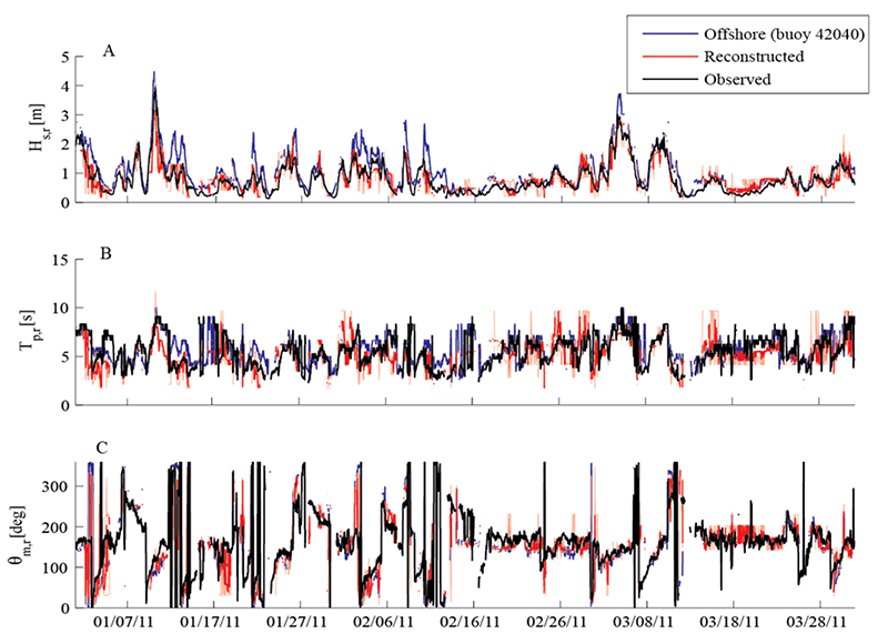
| Figure 8. Time series above shows a portion (January 1, 2011, through March 31, 2011) of the entire probabilistic wave reconstructed time series (August 24, 2000, to January 31, 2013) at buoy 42012 comparing the observations (black), reconstructed values (red; Long and others, 2014), and measurement at offshore buoy 42040 (blue). [m, meters; s, seconds; deg, degrees] | ||

![]() U.S. Department of the Interior |
U.S. Geological Survey
U.S. Department of the Interior |
U.S. Geological Survey
URL: http://pubsdata.usgs.gov/pubs/of/2015/1055/ofr2015-1055_figure8.html
Page Contact Information: GS Pubs Web Contact
Page Last Modified: Monday, 28-Aug-2017 17:34:48 EDT
