Introduction

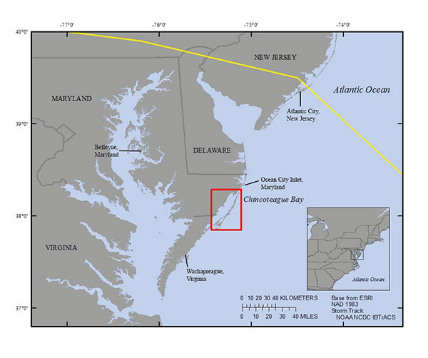
Figure 1. Regional map showing the location of Chincoteague Bay on the East Coast of the United States. The study area is indicated by the red box. Hurricane Sandy's storm track is indicated by the yellow line (Knapp and others, 2010). [Click to enlarge]
During storm events, currents and waves modify the benthic boundary layer of estuarine systems and alter the distribution of sediments. How these sediments respond to the hydrodynamic conditions associated with storms is often difficult to assess because comprehensive and recent baseline conditions (specifically pre-storm conditions) frequently do not exist. As a result, evaluating the recovery or return to pre-storm conditions may be challenging; in those situations, we must determine the current state of the system through multiple proxies including the collection of field data. With field data, we can effectively calculate change, assess the accuracy and functionality of models, and evaluate pre- and post-storm change with hydrodynamic and sediment transport models.
As part of the U.S. Geological Survey (USGS) response to Hurricane Sandy as funded under the Disaster Relief Appropriations Act (Buxton and others, 2013), scientists from the St. Petersburg Coastal and Marine Science Center (SPCMSC) carried out a sediment sampling study in Maryland (MD) and Virginia’s (VA) Chincoteague Bay system (fig. 1, 2, 3) as part of the Estuarine Physical Response to Storms project (EPR). The collection and evaluation of sediment physical characteristics in the study area helps determine a baseline of the sediment distributional patterns in the bay and the provenance of these materials. By conducting seasonal sampling during the spring and fall, a greater understanding of the seasonal variability can be used to tease out annual, small-scale distributional variations in the system from large-scale changes to the system like those caused by storms. Prior to the project, the immediate pre-storm sediment distribution was unknown, with the most recent and pertinent data collected at least 10 years ago and pertaining only to the Maryland portion of the study area (Wells and others, 1998; 2003). The project’s objective is to collect and analyze field data to create a baseline of physical sediment characteristics and distributional patterns in Chincoteague Bay, and incorporate the data into models as to better understand hindcast / nowcast modeling as it relates to storms.

