
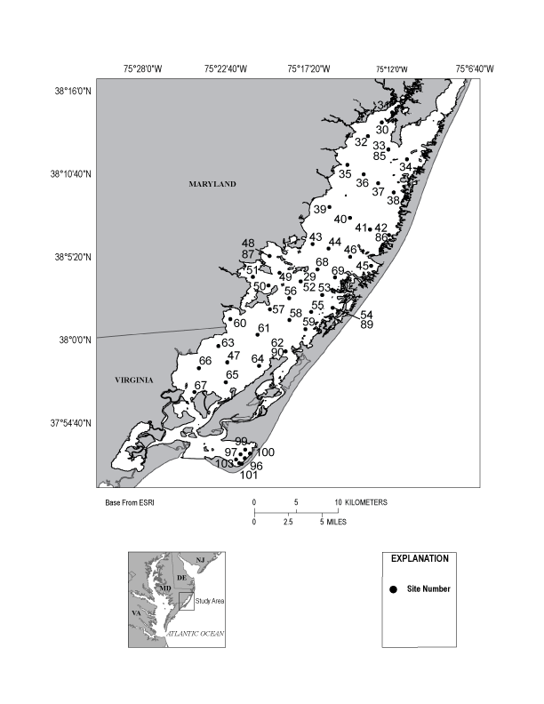
Results and Discussion


|
|
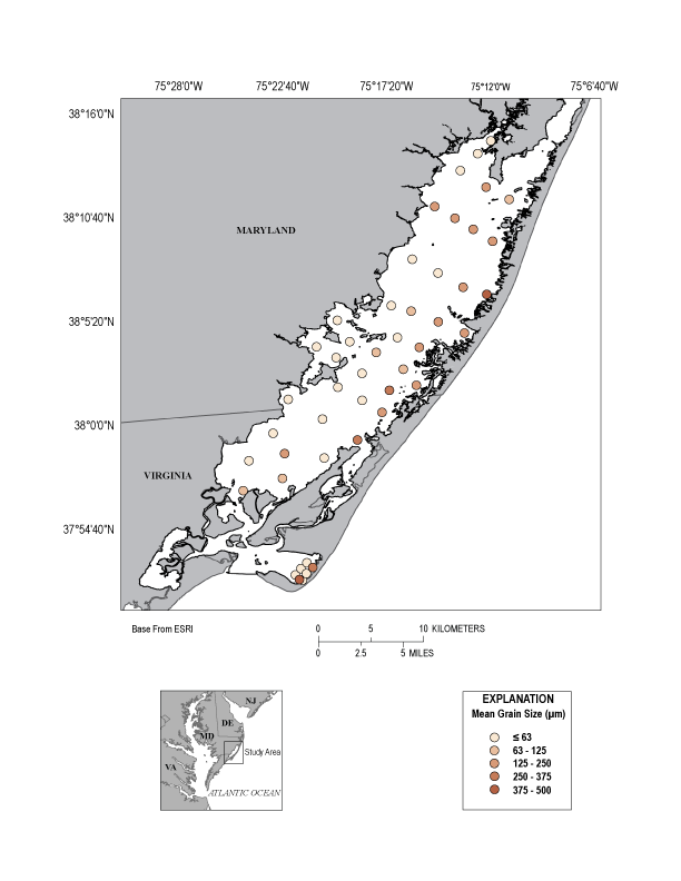
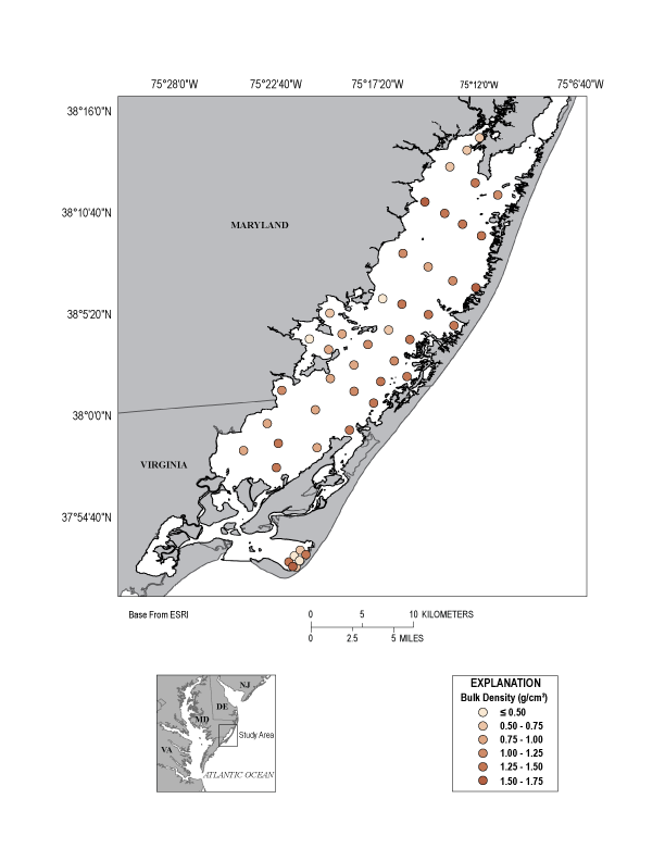
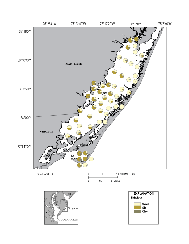
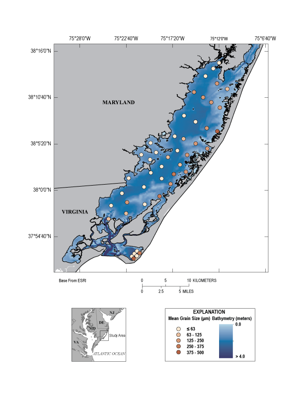
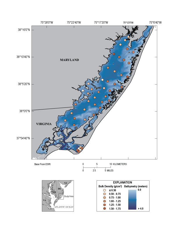
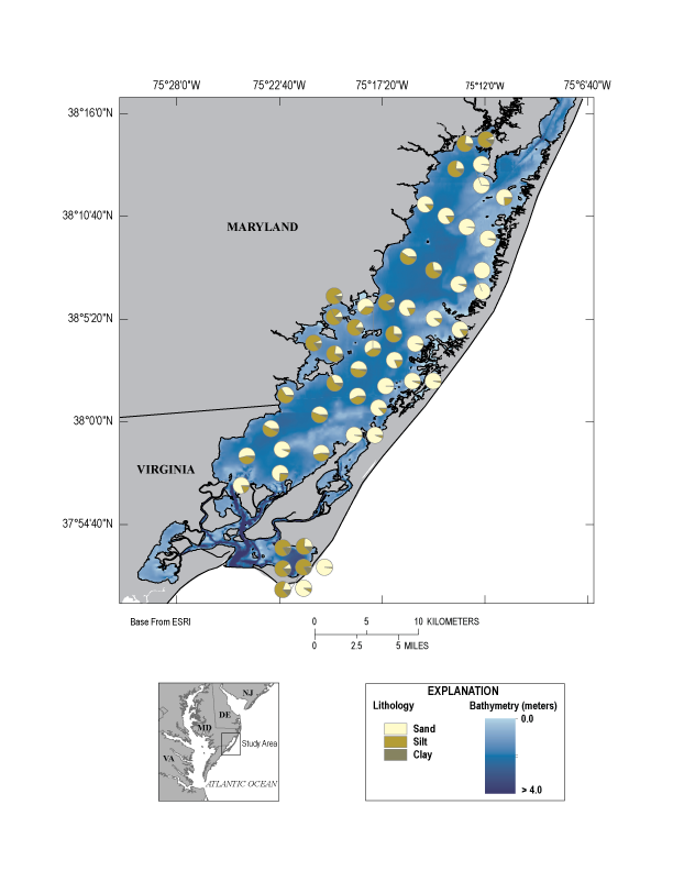
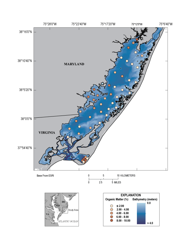
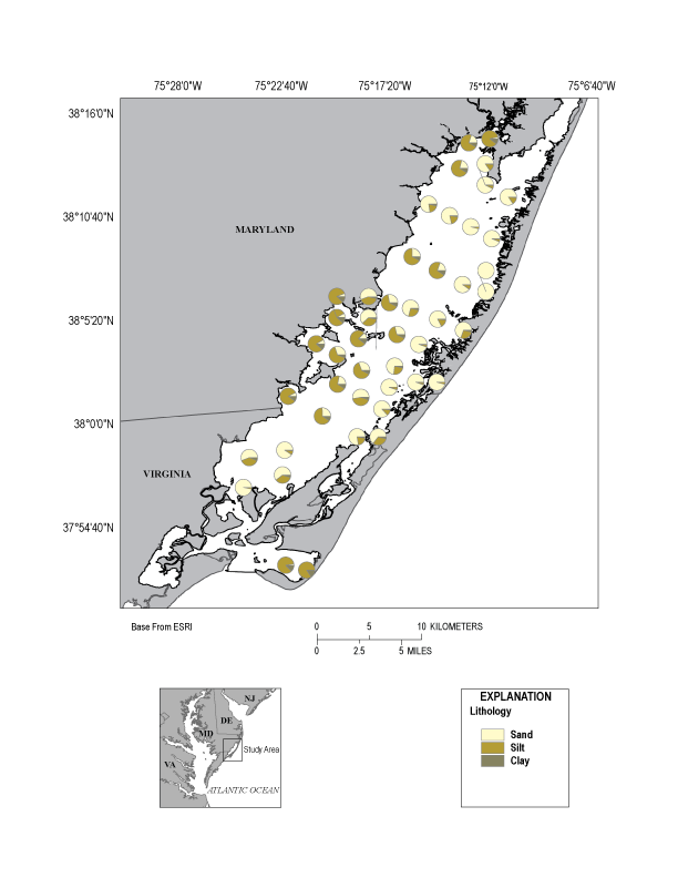
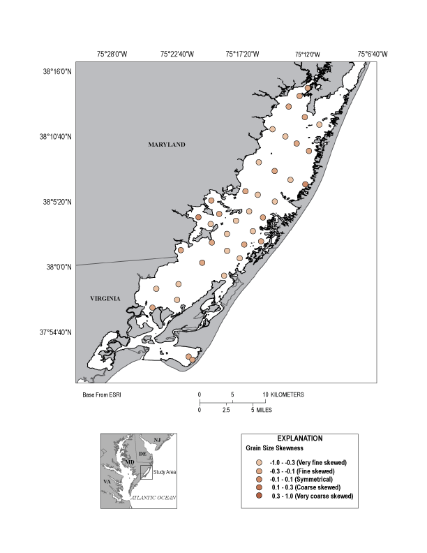
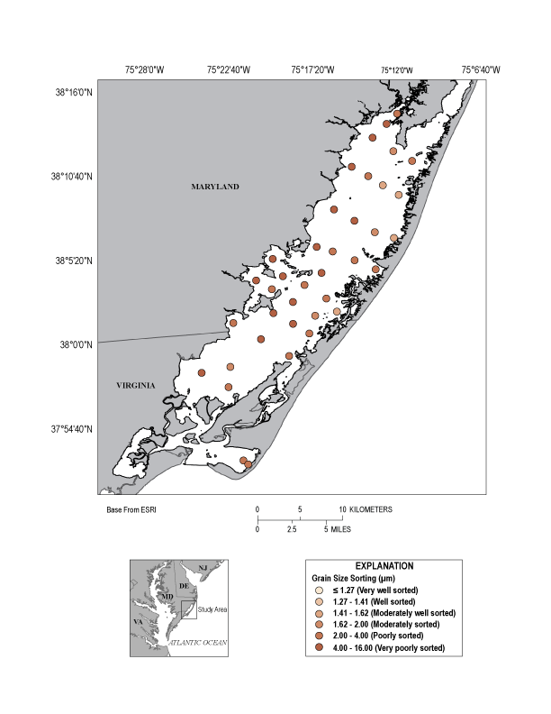
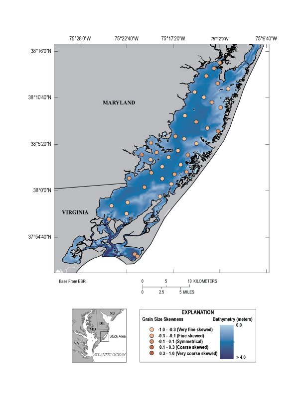
Figure 6. Interactive maps (left map exhibits spring sample data, right map exhibits fall sample data) showing the spatial distribution of bulk density, LOI, porosity, mean grain-size, grain-size sorting, grain-size skewness, lithology pie chart, and critical stress threshold values.
Environmental Variables
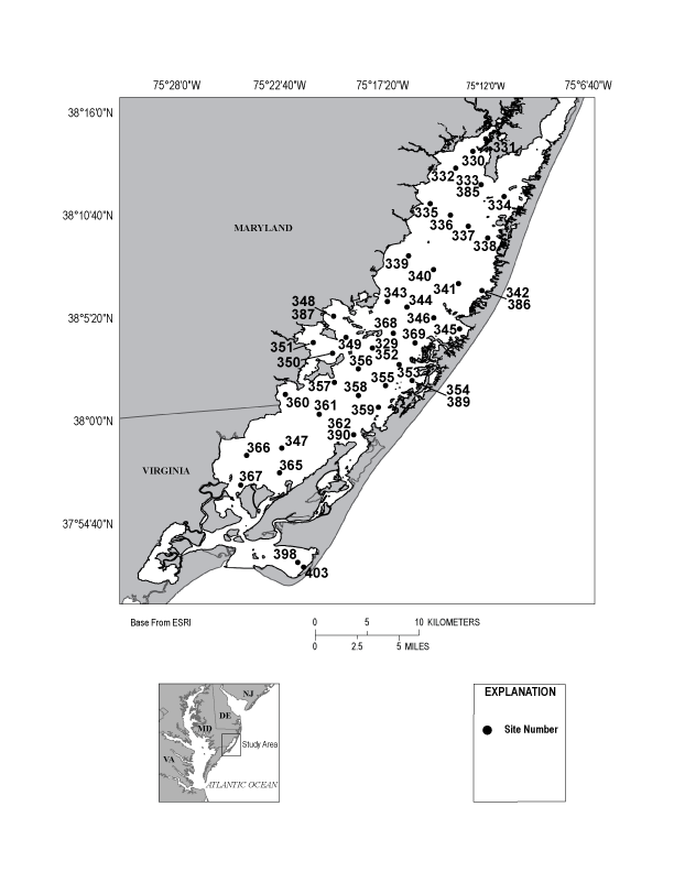
Sample location (sample ID, sampling dates, latitude, longitude, and water depth) and water quality parameter (temperature, barometric pressure, DO, specific conductance, salinity, pH, and ORP) data for both the spring and fall sampling sites are presented in the Site Information spreadsheet in the data downloads section of this report. During the spring 2014 sampling trip, salinity in Chincoteague Bay ranged between 19.1 at sample site 30, where Trappe Creek drains freshwater into the bay, and 29.7 at sample site 67 in the channel closest to Chincoteague Inlet (figs. 2, 3), with an average of 26.7. The salinity in Tom’s Cove exhibited little variation with a range between 30.4 and 30.8. Similarly, the pH values in both Chincoteague Bay and Tom’s Cove showed little variation ranging between 7.8 near Trappe Creek at sample site 31 and 8.1 near Purnell Hummock and Big Bay Marsh at sample site 49 (figs. 2, 3).
In contrast to the spring 2014 sampling trip, the salinity in the bay was higher during the fall 2014 sampling trip with an average of 31.6. Salinity was lowest at sample site 31/331 (28.8) closest to Trappe Creek, and highest at site 43/343 (32.5) near Purnell Hummock (figs. 2, 3). The salinity in Tom’s Cove was also slightly higher at 31.8 in the fall with a similar pH as during the spring. The pH in Chincoteague Bay during the fall sampling trip was more variable ranging between 6.4 (50.9 millivolts (mV)) at site 53/353 near the center of the bay, northwest of Pope Island, and 8.7 (83.4 mV) at 34/334, southeast of Sinepuxent Neck (figs. 2, 3). The difference in salinity between the two sampling trips generally reflects the contrast in hydrological inputs into the bay during the spring and fall. The low salinity observed during the spring sampling trip is probably related to the abundance of precipitation (approximately 7.5 cm of snow and wintry mix; National Weather Service Climate) that accumulated immediately preceding the spring sampling trip and fluxed into the bay. In contrast, the higher salinity during the fall sampling trip is likely indicative of greater evaporation rates during the summer.
Sediment Distribution and Parameters
Basic physical (water content, dry bulk density, porosity, and LOI) and grain-size (including mean, median, sorting, skewness, percent sand, silt, and clay) data for both the spring and fall sampling sites are presented in the Physical Parameters and Compiled Grain-Size Data spreadsheets in the data downloads section of this report. The six sample sites where field replicates were collected during the spring and fall sampling trip were analyzed to assess site variability. The mean difference in grain-size among field replicates is 6.33 μm for the spring samples and 19.77 μm for the fall. Field replicates exhibit a maximum difference in the spring and fall of 12.20 and 54.08 μm, respectively. Similarly, dry bulk density and LOI exhibited maximum differences of only 0.17 g/cm3 and 0.44 percent, respectively, between both sampling trips.
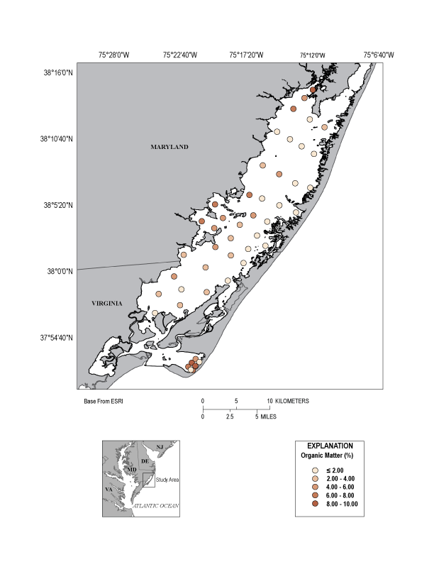
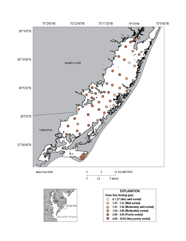
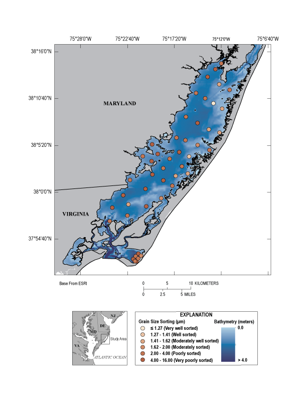
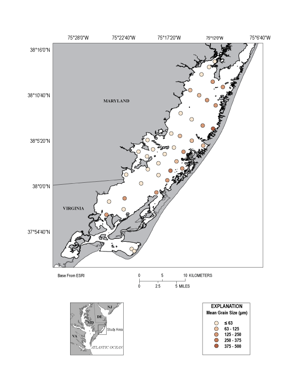
In the spring of 2014, the sediments of Chincoteague Bay ranged from medium silt to medium sand, were typically poorly-sorted, and finely skewed to symmetrical (fig. 6). Twenty-four of the 40 sample sites were composed of > 50 percent sand, excluding replicate samples taken at a single site. Dry bulk density ranged from 0.46 to 1.52 g/cm3 and percent LOI ranged between 0.33 and 9.83 percent with an average of 2.73 percent at all sample sites, including field replicates (fig. 6). These lagoonal sediments generally graded finer from east to west. The sites where sediments were composed primarily of sand during the spring sampling trip were mostly located on the back-barrier side of Assateague Island and towards the center of the bay. In contrast, sediment samples with a high silt and clay content were located on western side of the bay, adjacent to the mainland. The sample sites with the highest concentrations of clay are situated near Tizzard Island, Purnell Hummock, Big Bay Marsh, and where Trappe Creek drains into Chincoteague Bay (figs. 2, 6). A Pearson product-moment correlation with percent clay, percent water content, dry bulk density, and percent LOI implies a strong correlation between percent clay and percent water content (r = 0.964, P = <0.001), percent clay and percent LOI (r = 0.968, P = <0.001), percent water content and percent LOI (r = 0.964, P = <0.001), and percent clay and dry bulk density (r = -0.950, P = <0.001).
Similar to the spring 2014 sampling trip, samples collected in Chincoteague Bay during the fall exhibited a range from medium silt to medium sand, were generally poorly-sorted, and finely skewed to symmetrical (fig. 6). The spatial offset between the spring and fall sampling trips in Chincoteague Bay averages 10.3 m with a maximum offset at site 39/339G of 35.0 m and a minimum of 0.9 m. Thirty of the thirty-eight repeat sample sites in Chincoteague Bay, excluding replicate field samples collected at a single site, retained the same sediment texture classification from the spring to the fall. A regression was run on all spring and fall repeat sample site data to help determine outliers based on the one sigma prediction bands calculated in SigmaPlot (www.sigmaplot.com) in regards to percent LOI (r2 = 0.914), dry bulk density (r2 = 0.749), percent water content (r2 = 0.787), mean grain-size (r2 = 0.867), and percent sand (r2 = 0.929), silt (r2 = 0.934), and clay (r2 = 0.873). All sample sites fell within the prediction bands with the exception of six sample sites which include 62/362G, where Assateague Bay drains into Chincoteague Bay; 67/367G, the southern-most site in Chincoteague Bay where Chincoteague Bay connects to Chincoteague Inlet by a deep (5.1 m) meandering channel; 30/330G, close to where Trappe Creek drains into Chincoteague Bay; and 39/339G, 60/360G, and 43/343G which all border the Delmarva Peninsula (figs. 3, 6). Four of these six sample sites, with the exception of 30/330G and 67/367G, also represent sites where the greatest difference was exhibited for all sediment and grain-size parameters. The average and maximum differences between repeat sample sites (excluding Tom’s Cove, field, and lab replicates) from the spring and fall sampling trips were generally small for all sediment and grain-size parameters including percent LOI (0.65 and 2.69 percent), dry bulk density (0.15 g/cm3 and 0.41 g/cm3), percent water content (5.59 and 16.92 percent), mean grain-size (23.51 μm and 172.98 μm), percent sand (7.71 and 26.88 percent), silt (6.52 and 23.47 percent), and clay (1.33 and 6.38 percent).
Bartberger (1976) estimated that two-thirds of the coarse sediments (sands and coarse-grained silts) in Chincoteague Bay are derived from Assateague Island via overwash events and that one-third are a result of eolian transport. Data from the spring and fall sampling trips of 2014 exhibit a coarsening of the sediment texture in the bay with increasing proximity to Assateague Island (fig. 6). Similarly, sediment samples collected near Sinepuxent Neck, with the exception of those closest to where Trappe Creek drains into Chincoteague Bay, also consist of dominantly sand (figs. 2, 6). Sinepuxent Neck, Mills Island, and Big Bay Island have been interpreted to be remnant Pleistocene beach ridges (Rasmussen and Slaughter, 1955) that are now covered with marsh vegetation. These features are predominately comprised of coarse sediments with some fine-grained material and are eroding at a rapid rate. Big Bay Island is estimated to have the highest erosion rate of 8,740 cubic meters per year (m3/yr) followed by Mills Island (4,263 m3/yr), the west shore of the Delmarva Peninsula from Purnell Hummock to the VA state line (2,850 m3/yr) and Tizzard Island (919 m3/yr) (fig. 2) (Singewald and Slaughter, 1949; Bartberger, 1973).
The fine-grained sediments rich in organic matter in Johnson Bay, an embayment of Chincoteague Bay surrounding Tizzard Island, are likely a result of marsh shore erosion from the nearby islands and the Delmarva coastline (figs. 2, 6). Bartberger (1973) estimated that shore erosion contributes approximately eight times more fine-grained material than is introduced by streams in Chincoteague Bay. The portions of the shoreline exposed to the northeast (NE) and east-northeast (ENE) direction are subjected to some of the highest erosion rates in the bay (0.6 to 2.4 meters per year) (Conkwright, 1975). As coarse- and fine-grained sediment is eroded from shorelines exposed to the NE and ENE, fine-grained material is likely transported and deposited in sheltered areas with diminutive wave activity, like Johnson Bay (fig. 2). Wells and others (1998) estimated average sedimentation rates for Johnson Bay of 0.17 ± 0.08 and 0.25 ± 0.14 centimeters per year.
To a lesser extent, the islands of the Middlemoor complex (fig. 2) may be a source of both fine- and coarse-grained sediments in the bay. Many of the islands formed from coarse-grained ocean sediment while Green Run Inlet, one of many past inlets along Assateague Island, was open from 1790 until 1890, during which time it acted as a conduit for ocean sediments into Chincoteague Bay (Biggs, 1970; Carruthers and others, 2011). Since Green Run Inlet closed in 1890 (Carruthers and others, 2011), many of the islands have experienced periods of both erosion and accretion (Biggs, 1970; Bartberger, 1973). Sample sites on the western bounds of the Middlemoor complex still exhibit low organic content, moderately to well-sorted, sandy sediments remnant from the inlet opening (fig. 6).
Most streams draining into Chincoteague Bay contribute negligible amounts of sediment due to the low gradient of the land. However, the extensive marsh wetlands along Trappe Creek and its corresponding tributary drainage area supply small but notable amounts of organic-rich, fine-grained sediment to the bay (Wells and others, 1996; Maryland Department of Natural Resources, 2004). Sample site 31/331G, closest to the mouth of Trappe Creek, exhibits the highest percent organic matter of all sample sites for both the spring and fall sampling trip as well as the greatest percent clay of all sample sites besides those in the Purnell Hummock and Tizzard Island vicinity (fig. 6). These fine-grained sediments are likely preserved furthest north due to the protection provided by Sinepuxent Neck.
During the spring sampling trip, sediment samples collected in Tom’s Cove ranged from fine silt to medium sand and were poorly-sorted, with five of the seven samples symmetrically skewed, and composed of > 50 percent silt (though not the same five). During the fall sampling trip, little change was observed in the two repeat sample sites in Tom’s Cove with sediment samples consisting of symmetrically skewed, poorly-sorted, fine silt (fig. 6). The spatial offset for sample sites 98/398G and 103/403G between the spring and fall sampling trips is 17.8 and 40.1 m, respectively.
Shear Stress and Model Simulations
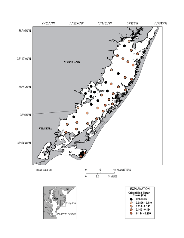
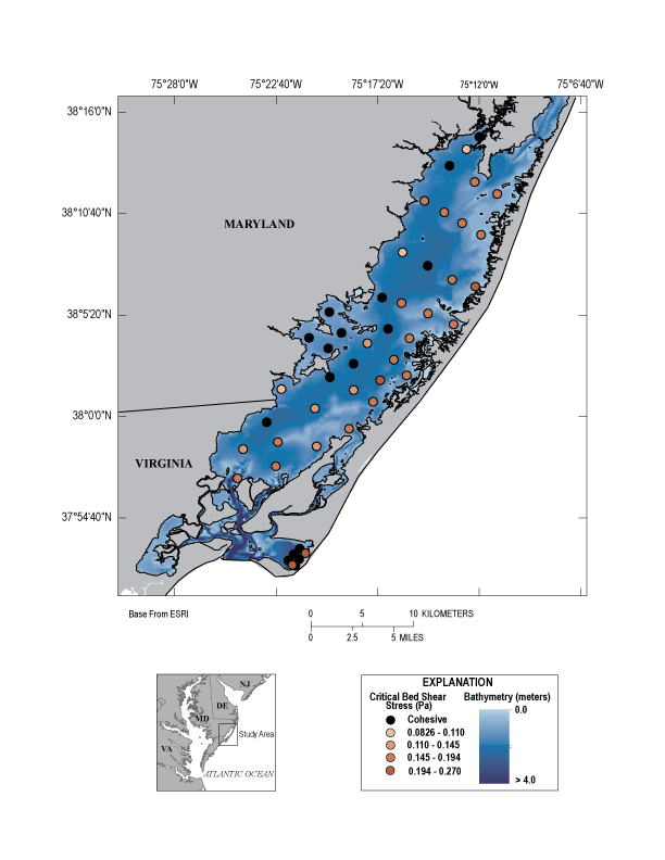
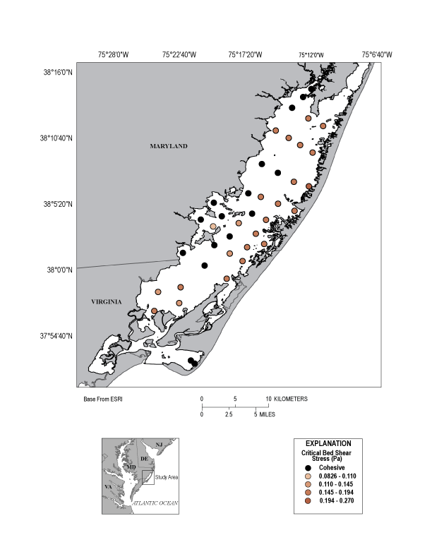
Critical stress thresholds were calculated using the grain-size data from the surface sediment samples collected in Chincoteague Bay during the spring and fall sampling trips of 2014 and are presented in the Shear Stress spreadsheet in the data downloads section of this report. Approximately 34 and 22 percent of the sediment samples collected during the spring sampling trip in Chincoteague Bay exceed the prescribed cohesive sediment bed criteria of 7.5 and 10 percent clay, respectively. Similarly, 37 and 24 percent, exceed the prescribed criteria from the fall sampling trip. Thus, for the bulk of the lagoonal sediments, critical stress threshold calculations based on the Shields criterion are applicable. Using Soulsby’s formulation, the critical shear stress required to remobilize sediments collected during the spring sampling trip, removing data that exceed 7.5 percent clay content, range from 0.0901 to 0.2264 Pa. Similarly, the critical stress threshold for sediments collected during the fall sampling trip, removing data that exceed 7.5 percent clay content, ranges from 0.0970 to 0.2238 Pa. The critical stress thresholds for cohesive sediments not only depend on grain-size and density but also depend on the fluid properties (salinity, temperature), sediment matrix properties (texture, chemical composition) and biological influences (bioturbation) (Dickhudt and others, 2011).
The combined wave-current shear stress (τtbs = τw + τc) exerted on the seafloor can be estimated from physical-based hydrodynamic models that simulate waves (τw) and currents (τc) forced by wind, astronomical tide, and atmospheric pressure. Total bottom shear stress data were obtained from model simulations conducted by the USGS Woods Hole Coastal and Marine Science Center as part of another task of the Hurricane Sandy Supplemental Funded Estuarine Physical Response to Storms project. Based on preliminary model simulations using the Coupled Ocean-Atmosphere-Wave-Sediment Transport (COAWST) modeling system from October 15, 2012 to November 15, 2012, with Hurricane Sandy filtered out (fair-weather conditions scenario), the mean bottom shear stress, as skin friction, for each spring sample site range from 0.0100 to 0.7315 Pa with a mean and standard deviation of 0.0844 ± 0.0973 Pa (via personal communication). Similarly, the mean bottom shear stress for each fall sample site under fair-weather conditions range from 0.100 to 0.7490 Pa with a mean and standard deviation of 0.0866 ± 0.1493 Pa. The methods and models discussed here are in preliminary, developmental stages. For now the model does not integrate benthic structures (such as shell beds and submerged aquatic vegetation), the presence of salt marshes, and may require some adjustments in regards to bathymetry and grain-size diameters, all of which could alter the bottom shear stress at a given sample location.
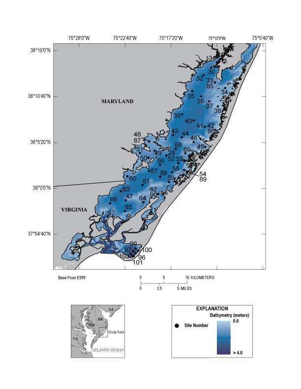
All of the applicable critical stress threshold values calculated from the non-cohesive sediment samples collected during the spring and fall sampling trips are greater than the preliminary model’s mean fair-weather condition values but less than the model’s max fair-weather condition values at that sample location. Although bed shear stress is likely to be variable during tidal cycles and meteorological events, the calculated values indicate that the sediments are not mobile under average fair-weather conditions but can be mobilized episodically during periods of increased exerted shear stress. The only exception is sample 67/367G, collected where Chincoteague Bay connects to Chincoteague Inlet by a deep (5.1 m) meandering channel (figs. 3, 6). It is likely that this area is heavily influenced by tidal currents due to its proximity to Chincoteague Inlet and, therefore, the surficial sediment is mobile under mean fair-weather conditions. Sediment from this site exhibits the greatest difference between calculated critical shear stress and mean modeled shear stress under fair-weather conditions of 0.5633 and 0.5771 Pa for the spring and fall 2014 sampling trips, respectively. The range between modeled mean fair-weather shear stress values and the calculated critical shear stress for some of the samples is narrow, indicating areas that are more vulnerable to small increases in exerted shear stress over fair-weather conditions and thus have the greatest chance of mobility. These sites include 47/347G, 44/344G, 58/358G, 65/365G, and 66/366G (figs. 3, 6). As sediment in the bay is made mobile by an increase in exerted shear stress, the fine-grained sediments that are deposited in and around the steadily accumulating protected waters of Johnson Bay likely flocculate, causing an increase in the cohesive properties of the already clay-rich sediments (figs. 2, 6). The sample site that would require the greatest increase in exerted shear stress to mobilize surficial sediment, and therefore the least likely to become mobile of the samples collected with < 7.5 percent clay, is 45/345G, near the back-barrier side of Assateague Island in a small, protected cove (figs. 3, 6). More work is currently being done to calculate the percentage of time the combined wave-current shear stress exceed the critical shear stress in order to assess the stability of the bed sediment. The preliminary model bottom shear stress values from the October 15 to November 15, 2012, simulations indicate mostly good agreement with critical shear stress values calculated from the sediment samples collected in the spring and fall. Such agreement is important for model validation. This sediment dataset can be used in the hydro-sedimentary model as input to compute multi-grain sediment transport in fair-weather and storm conditions (in particular, for Hurricane Sandy).
