Open-File Report 2016-1119
Shallow Geology, Sea-Floor Texture, and Physiographic Zones of Vineyard and Western Nantucket Sounds, Massachusetts
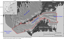
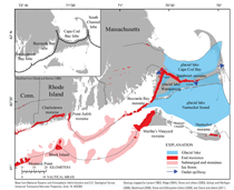
IntroductionThe geologic framework and seabed character of the Massachusetts coastal ocean is complex and difficult to map. Previous studies defined the geology and texture of the sea floor in Vineyard and Nantucket Sounds on the basis of widely spaced geophysical tracklines and vibracores (O’Hara and Oldale, 1980, 1987) or sediment samples (Ford and Voss, 2010). Early mapping methods for homogenous, nonglaciated regions relied on contouring changes in grain size (for example, Hollister, 1973), but in previously glaciated regions like southeastern Massachusetts, seabed compositional changes occur over spatial scales that are typically smaller than a reasonable sampling grid can resolve. In this cooperative study, the U.S. Geological Survey (USGS) and the Massachusetts Office of Coastal Zone Management (CZM) used high-resolution geophysical data with full sea-floor coverage, sediment samples, and bottom photographs/video to interpret and map surface and shallow subsurface geology, sea-floor sediment texture, and sea-floor physiographic zones at resolutions previously unattainable because of a lack of high-quality, high-density sea-floor mapping data. Purpose and ScopeThis report describes the geologic framework and sea-floor character of Vineyard and western Nantucket Sounds (fig. 1). We present interpretive maps of shallow stratigraphy, surficial geology, surficial sediment texture, and physiographic zones. The geologic interpretations are based on several geophysical surveys (table 1), sediment sample databases (Ford and Voss, 2010; McMullen and others, 2012; Emily Huntley, CZM, written communication, 2014), and bottom photographs/video (Ackerman and others, 2015; Golden and Ackerman, 2015). Interpretations and associated data are provided as geospatial data layers in Esri ArcGIS formats (Appendix 1 — Geospatial Data), which merge with those published by Foster and others (2015) for adjacent Buzzards Bay. This research was conducted as part of a cooperative program of the USGS and CZM, which provides interpretive geologic datasets that can be used by managers and scientists to delineate marine resources, assess environmental change, inventory marine habitats, and support research concerning sea-level change, sediment supply, and coastal evolution. Detailed information and mapping products related to this cooperative can be accessed at http://woodshole.er.usgs.gov/project-pages/coastal_mass/. Geographic SettingVineyard Sound is a narrow seaway in southeastern Massachusetts that connects western Nantucket Sound to eastern Rhode Island Sound and the Atlantic Ocean (fig. 1). The study area has a mean water depth of approximately 13 meters (m) and deepens to greater than 38 m near its westernmost extent; it is bordered by Cape Cod and the Elizabeth Islands to the north and Martha’s Vineyard to the south. The north coast between Mashpee and Falmouth consists of a low-relief, gently south-sloping plain, that contains a series of elongate, roughly shore-perpendicular coastal embayments (drowned valleys) fronted by narrow arcuate beaches. Southwest of Falmouth, between Woods Hole and Cuttyhunk Island, the Elizabeth Islands form a rocky and topographically rugged shoreline that is segmented by a series of narrow straits, locally referred to as “holes,” connecting Vineyard Sound to Buzzards Bay. The southern shore of Vineyard Sound along western Martha’s Vineyard is similarly rugged between the Aquinnah cliffs and Vineyard Haven. East of Oak Bluffs, the coast of Martha’s Vineyard is of relatively low relief and characterized by a series of coastal embayments, several of which are fronted by arcuate beach strands. Geologic FrameworkThe geologic framework of Vineyard and western Nantucket Sounds is broadly defined by the antecedent structure of underlying bedrock and coastal plain and continental shelf units, as well as deposition and erosion related to Pleistocene glaciations and Holocene sea-level rise (O’Hara and Oldale, 1980, 1987; Uchupi and others, 1996). Basement rocks of Proterozoic to Jurassic ages are inferred to underlie the southeastern Massachusetts coast, Cape Cod, and the sounds and islands to the south (Oldale, 1969; Zen and others, 1983; Uchupi and others, 1996). The gently seaward-dipping basement surface is deeply incised, presumably because of fluvial erosion during the Cretaceous (Oldale, 1969; McMaster and Ashraf, 1973; Oldale and others, 1973; O’Hara and Oldale, 1980, 1987). It is mostly shallower than 100 meters below sea level (mbsl) beneath Buzzards Bay, the western margin of Cape Cod, and the Elizabeth Islands (Brocher and Ewing, 1986; Fairchild and others, 2013), but it deepens up to 350 mbsl beneath Vineyard Sound, western Nantucket Sound, and Martha’s Vineyard (Oldale, 1969; Oldale and others, 1973; O’Hara and Oldale, 1980, 1987). South of Cape Cod and the Elizabeth Islands, beneath the sounds, Martha’s Vineyard, and Nantucket, basement rocks are unconformably overlain in part by Cretaceous and Tertiary coastal plain and continental shelf deposits (Woodsworth and Wigglesworth, 1934; Kaye, 1964a, b, 1980; Oldale and others, 1973; Folger and others, 1978; Hall and others, 1980; O’Hara and Oldale, 1980, 1987; Oldale and O’Hara, 1984). These deposits are composed of unconsolidated to semiconsolidated sand, silty clay, and some gravel, and they represent the truncated northern margin of a wedge of coastal plain and continental shelf strata that gently dips and thickens to the south (Weed and others, 1974; O’Hara and Oldale, 1980, 1987; Siegel and others, 2012). Glacial drift sediments, deposited during the Illinoian and Wisconsinan glacial stages of the Pleistocene, unconformably overlie the basement rocks and coastal plain and continental shelf deposits throughout the region (Woodsworth and Wigglesworth, 1934; Kaye, 1964a, b; O’Hara and Oldale, 1980, 1987; Oldale, 1981, 1982, 2001; Uchupi and others, 1996; Masterson and others, 1997; Uchupi and Mulligan, 2006; Stone and DiGiacomo-Cohen, 2009). The glacial drift is up to 180 m thick and composed of glacial detritus (grain sizes from mud to boulders) transported southward by the Buzzards Bay and Cape Cod Bay lobes of the Laurentide ice sheet (O’Hara and Oldale, 1980, 1987). Subunits within the drift include poorly sorted tills and moraines, indicative of ice-proximal deposition, and moderately to well sorted and stratified glaciofluvial, glaciodeltaic, and galciolacustrine units, indicative of relatively ice-distal deposition. Postglacial deposits primarily consist of fine-grained material that has been winnowed from the glacial drift by marine and fluvial processes during the late Pleistocene and Holocene (O’Hara and Oldale, 1980, 1987; Oldale, 1981, 2001; Uchupi and others, 1996). The thickness of postglacial material ranges from a discontinuous veneer (less than 1 m) to accumulations up to 14 m thick (O’Hara and Oldale, 1980, 1987). The oldest postglacial deposits are fluvial and estuarine units that fill glaciofluvial channels and other topographic lows on the surface of the glacial drift (O’Hara and Oldale, 1980, 1987; Gutierrez and others, 2003). The Holocene marine transgressive unconformity separates the older units from younger overlying postglacial marine deposits. The marine units primarily consist of muds and muddy sands in deepwater-marine and nearshore-estuarine settings, and sandy beaches, bars, and shoals along the shorelines and shallow central areas of the sounds. Depositional HistoryBetween 25.5 and 28 thousand years before present (ka), the Buzzards Bay and Cape Cod Bay lobes of the Wisconsinan Laurentide ice sheet reached their maximum southern extents in the vicinity of Martha’s Vineyard and Nantucket (fig. 2; Uchupi and others, 1996; Oldale, 2001; Balco and others, 2002; Uchupi and Mulligan, 2006; Balco, 2011). The overburden of the advancing ice front locally deformed and thrusted previously deposited glacial drift and underlying coastal plain and continental shelf units into the terminal moraines that now form the western and northeastern coasts of Martha’s Vineyard and Nantucket, respectively (Woodsworth and Wigglesworth, 1934; Mather and others, 1942; Kaye, 1964a, b; Oldale and O’Hara, 1984; Oldale, 2001). The two ice lobes then began to recede northward asynchronously, undergoing stagnation zone retreat (Larson, 1982; Oldale and O’Hara, 1984). As the lobes receded, coarse and poorly sorted till and ice-contact material was deposited proximal to their ablating fronts, while finer-grained and stratified fluvial outwash, lacustrine, and delta material was deposited beyond the ice fronts. Ice contact and stratified drift deposited during the retreat partially filled the newly ice-free lowland areas that are now Buzzards Bay and Nantucket and Vineyard Sounds (Robb and Oldale, 1977; O’Hara and Oldale, 1980, 1987; Uchupi and Mulligan, 2006; Foster and others 2015) and formed the expansive outwash deposits of the Mashpee Pitted Plain (fig. 1), which composes the bulk of western Cape Cod (Oldale, 1981, 2001; Uchupi and others, 1996; Masterson and others, 1997; Uchupi and Mulligan, 2006; Stone and DiGiacomo-Cohen, 2009). Eventually both lobes readvanced between 20.5 and 22.5 ka to form the ice-thrusted Sandwich and Buzzards Bay end moraines along what are now the north and west margins of Cape Cod and the Elizabeth Islands (fig. 2; Uchupi and others, 1996; Oldale, 2001; Balco and others, 2002; Uchupi and Mulligan, 2006; Balco, 2011). Throughout the glacial recession from the Martha’s Vineyard and Nantucket moraines to the Buzzards Bay and Sandwich moraines, the meltwater shed from the ablating ice established and continually modified a glaciofluvial drainage network though Vineyard and Nantucket Sounds (O’Hara and Oldale, 1980, 1987; Gutierrez and others, 2003; Uchupi and Muligan, 2006). The drainage ultimately exited beyond the terminal moraines through western Vineyard Sound, between Aquinnah and Cuttyhunk Island, and through Muskeget Channel, between Martha’s Vineyard and Nantucket (figs. 1 and 2). Even after the Cape Cod Bay lobe receded north of the Sandwich moraine (by about 17 ka), the drainage pathways through the sounds were fed through groundwater seepage from glacial lake Cape Cod Bay (fig. 2), which is the mechanism thought to have caused incision of an extensive network of spring sapping valleys into the Mashpee Pitted Plain (Uchupi and Oldale, 1994; Uchupi and others, 1996). Postglacial fluvial systems also modified the drainage network, further eroding the drift exposed at the surface of the sounds, until approximately 8 to 10 ka when sea level began to transgress the glacial, glaciofluvial, and estuarine deposits (Oldale and O’Hara, 1980; O’Hara and Oldale, 1980, 1987; Gutierrez and others, 2003). Subsequently, waves and strong tidal currents reworked, winnowed, and redistributed fine-grained material from the glacial drift (O’Hara and Oldale, 1980, 1987). Muddy marine deposits are located in deep and quiet-water embayment areas, and sandy marine deposits have partially filled some of the fluvial and tidal channels. Primarily sandy beaches have accumulated along the shorelines of Cape Cod and the islands, and thick, sandy shoals have formed in areas of strong tidal convergence. Previous Geologic MappingO’Hara and Oldale (1980, 1987) conducted the most comprehensive geologic mapping studies of Vineyard and Nantucket Sounds prior to this study. They collected widely spaced (approximately 2,000 meters apart) boomer seismic-reflection profiles, sidescan sonographs, and vibracores. Their interpretations described the broad stratigraphic framework of the sounds and were conveyed in a series of subsurface and sea-floor geologic maps, including structural contours of depths to the surfaces of pre-Quaternary coastal plain and continental shelf units and Quaternary glacial units, and thickness isopachs of glacial and postglacial sediments. Smith (1969) utilized bottom grab samples, bathymetric data, and current velocity measurements to investigate the geomorphology, origin, and evolution of the Middle Ground and Lucas Shoals tidal sand ridges in Vineyard Sound. Poppe and others (2007, 2008, and 2010) used acoustic backscatter, multibeam bathymetry, seismic-reflection profiles, sediment samples, and bottom photographs to interpret sea-floor character in the vicinities of Quicks Hole, Woods Hole, and Edgartown. Ford and Voss (2010) compiled a database consisting of grab sample, video, and photographic data for Massachusetts State waters, including portions of Vineyard and Nantucket Sounds. Ford and Voss (2010) evaluated their data for quality and generated sea-floor sediment texture maps by using point interpolation and Thiessen polygon techniques.
|

![]() U.S. Department of the Interior |
U.S. Geological Survey
U.S. Department of the Interior |
U.S. Geological Survey
URL: http://pubsdata.usgs.gov/pubs/of/2016/1119/ofr20161119_introduction.html
Page Contact Information: GS Pubs Web Contact
Page Last Modified: Wednesday, 11-Oct-2017 17:56:38 EDT