Open-File Report 2016–1168
High-Resolution Geophysical Data From the Inner Continental Shelf: South of Martha’s Vineyard and North of Nantucket, Massachusetts
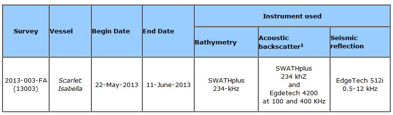
Table 1. Survey details for the data collected in the study areas south of Martha’s Vineyard and north of Nantucket, Massachusetts, May to June 2013. [A U.S. Geological Survey field activity number (for example, 2013–003–FA) may also be referenced as a five-digit number (for example, 13003). kHz, kilohertz] 1Backscatter data were collected during this survey using the SEA SWATHplus and an Edgetech 4200 sidescan sonar; only the SWATHplus interferometic backscatter were processed and are being published in this report. |

![]() U.S. Department of the Interior |
U.S. Geological Survey
U.S. Department of the Interior |
U.S. Geological Survey
URL: http://pubsdata.usgs.gov/pubs/of/2016/1168/ofr2016-1168-table1.html
Page Contact Information: GS Pubs Web Contact
Page Last Modified: Wednesday, 07-Dec-2016 23:31:01 EST
