FISC - St. Petersburg
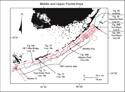
Figure 69. Index map shows USGS seismic tracklines (red) in upper and middle Florida Keys and those portions of profile data selected (bold black) from the Tile 1, 2, and 4 sectors for illustration with their figure numbers (modified from Lidz et al., 2003). Note that profiles illustrated in Tiles 2 (Fig. 49B) and 4 (Figs. 70, 72, 73, 74B) were acquired in 1997 and constitute part of the 'new' high-resolution seismic data used to develop the updated Bedrock Surface and Sediment Thickness maps. Shelf-margin contour (blue) is in meters.
|
Can't see the printable PDF version? Get the free Adobe Acrobat® Reader. |

![]() U.S. Department of the Interior |
U.S. Geological Survey
U.S. Department of the Interior |
U.S. Geological Survey
URL: [disc] /pubs/pp/2007/1751/professional-paper/tile4/figures/fig69.html
Page Contact Information: Feedback
Page Last Modified: December 01, 2016 @ 04:13 PM (JSS)
