
|
|
Scientific Investigations Map 2940 |
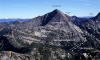
| Qt-1. Talus (Qt) fringes steep slopes beneath Castle Peak (Eocene granodiorite rocks of late and post-orogenic extension, Tei) and Freezeout Mountain (Three Fools sequence of Haugerud and others (2002), Ktf). Broad floor of Castle Creek valley is covered with glacial drift deposited by the Cordilleran ice sheet (Qga). View west from Mount Winthrop [RMnw]. View image with annotation |

|
Other photos that show unit Qt:
     |