Scientific Investigations Map 3220
ABSTRACT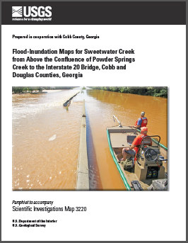
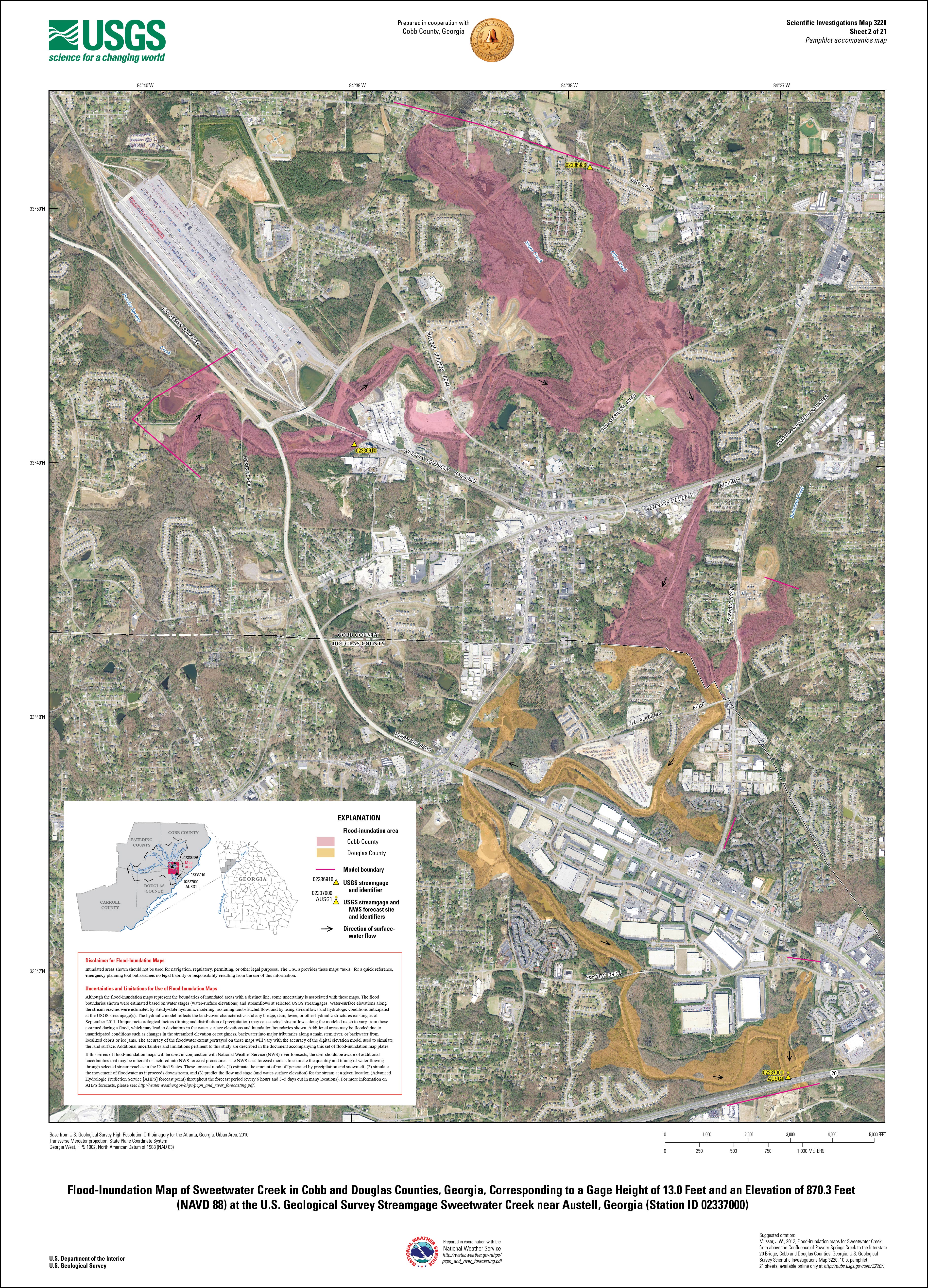
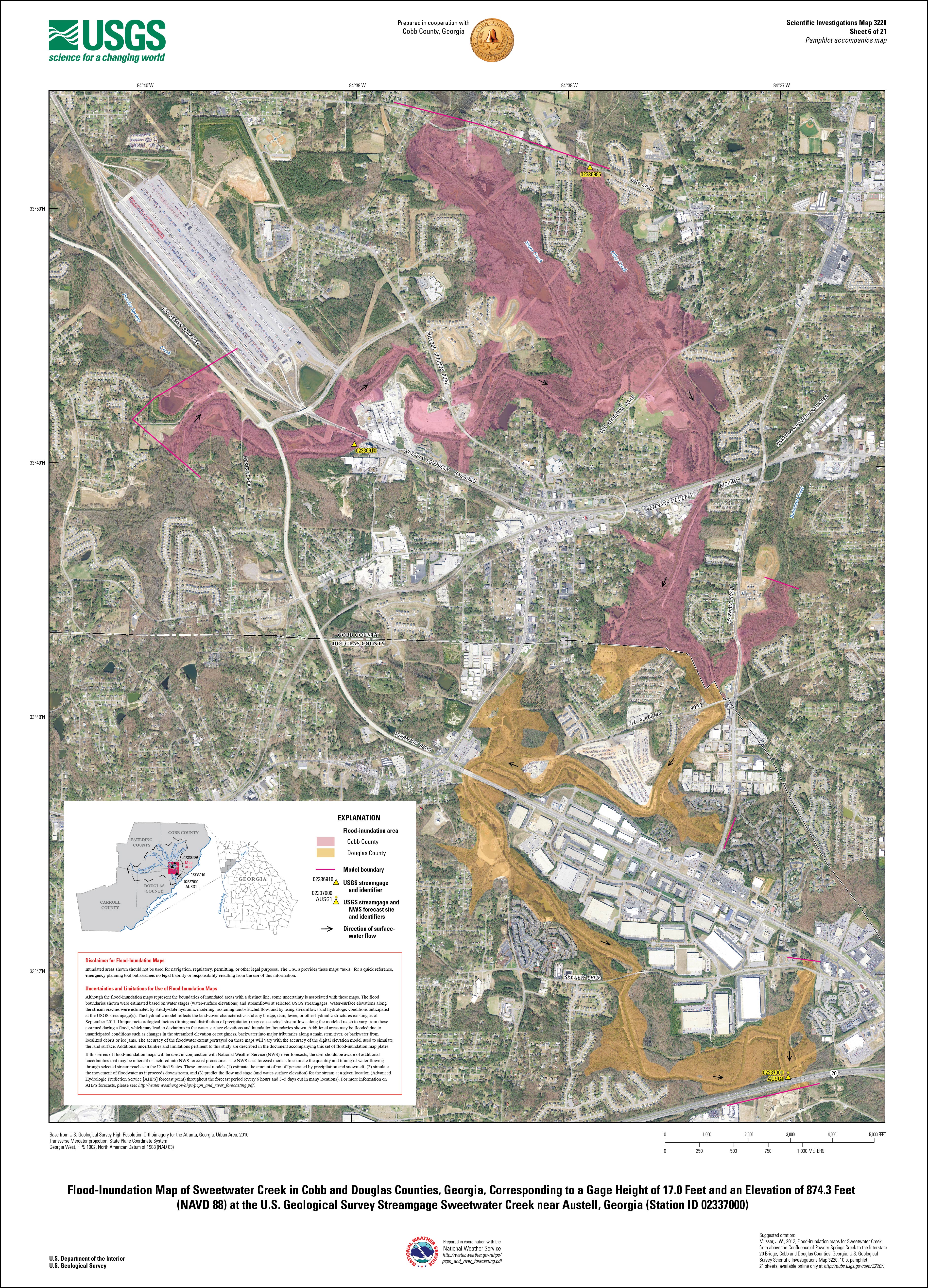
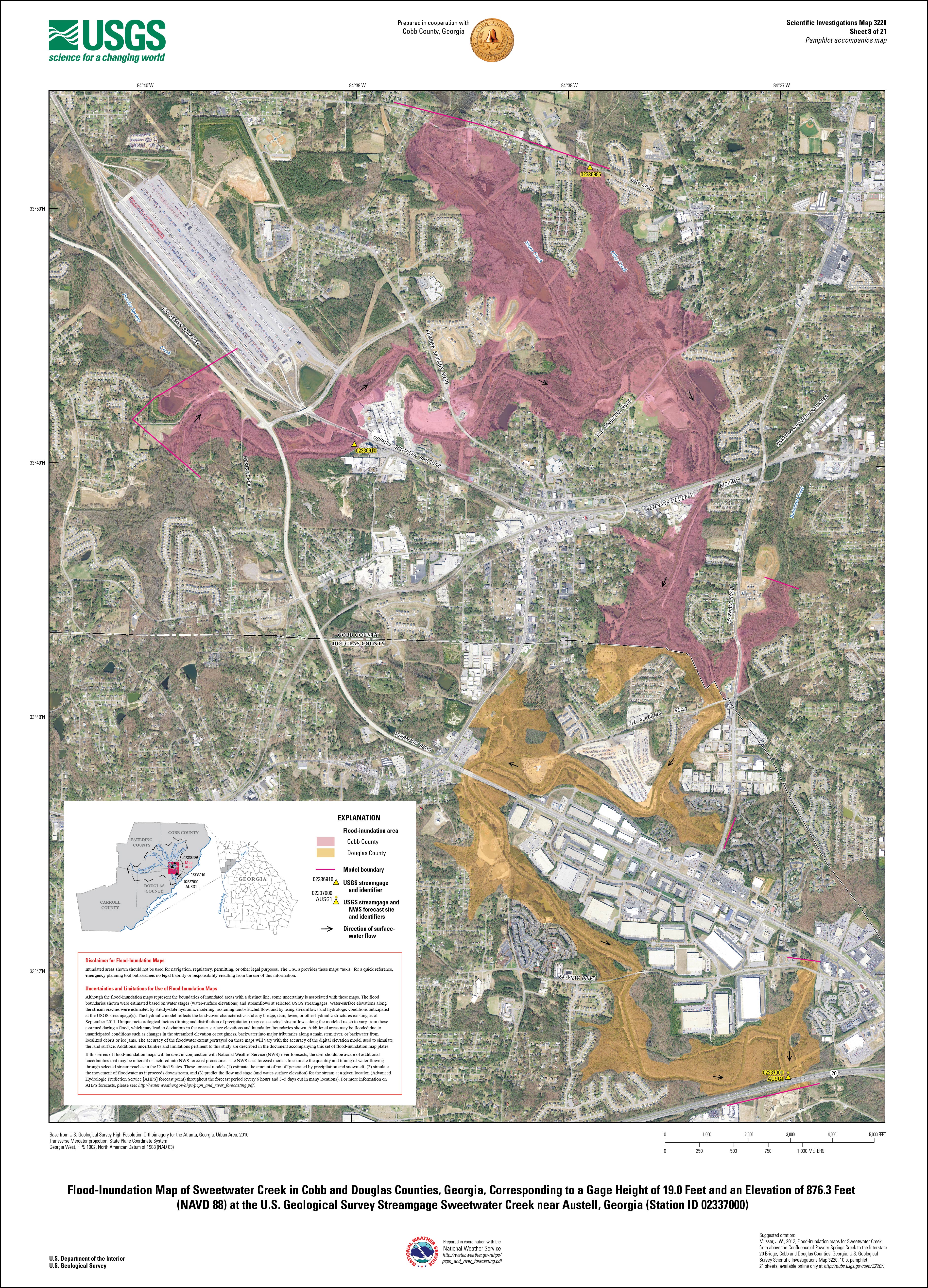
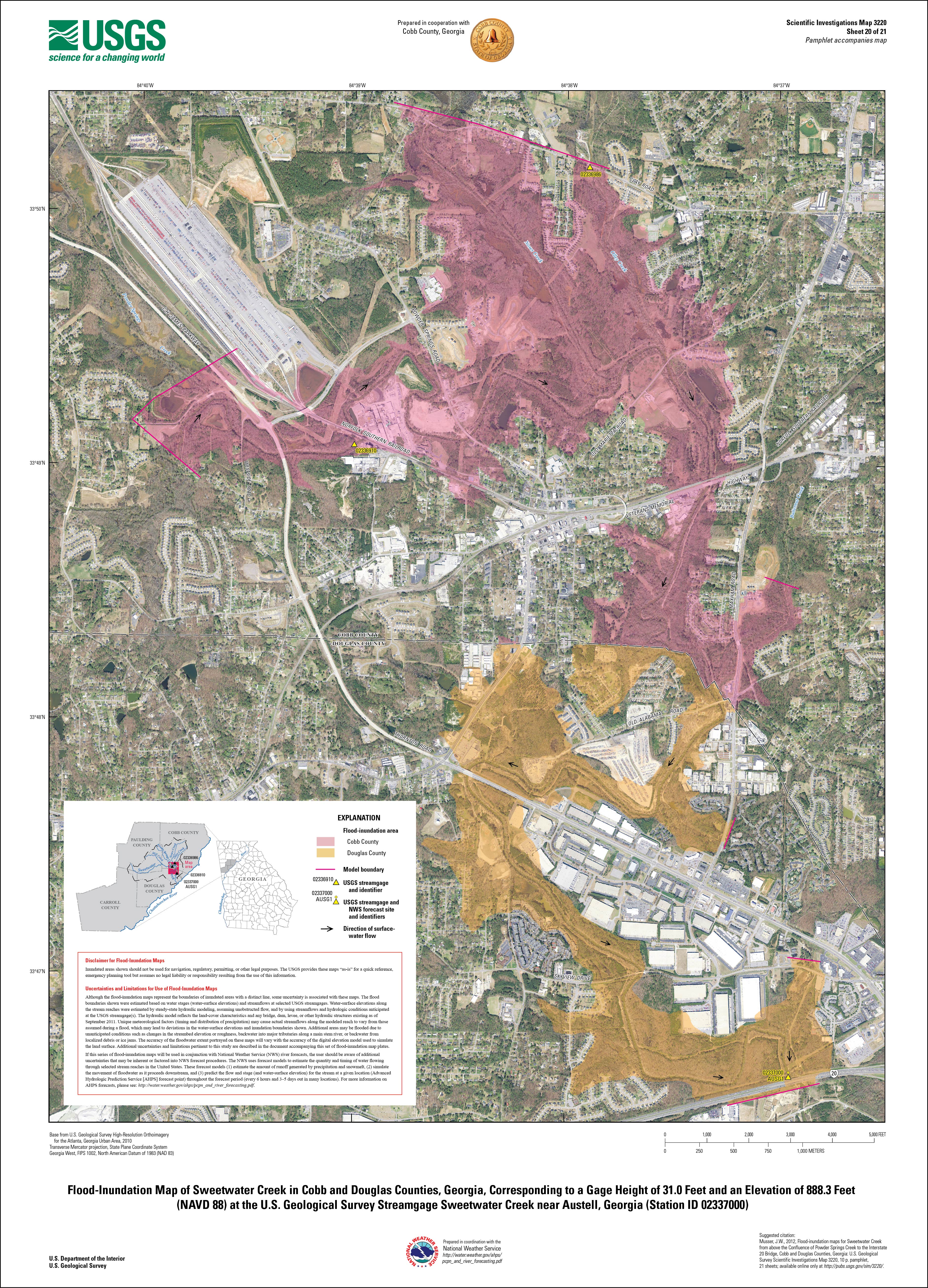
Digital flood-inundation maps for a 10.5-mile reach of Sweetwater Creek, from about 1,800 feet above the confluence of Powder Springs Creek to about 160 feet below the Interstate 20 bridge, were developed by the U.S. Geological Survey (USGS) in cooperation with Cobb County, Georgia. The inundation maps, which can be accessed through the USGS Flood Inundation Mapping Science Web site at http://water.usgs.gov/osw/flood_inundation/, depict estimates of the areal extent and depth of flooding corresponding to selected water levels (stages) at the USGS streamgage at Sweetwater Creek near Austell, Georgia (02337000). Current stage at this USGS streamgage may be obtained at http://waterdata.usgs.gov/ and can be used in conjunction with these maps to estimate near real-time areas of inundation. The National Weather Service (NWS) is incorporating results from this study into the Advanced Hydrologic Prediction Service (AHPS) flood-warning system (http://water.weather.gov/ahps/). The NWS forecasts flood hydrographs at many places that commonly are collocated at USGS streamgages. The forecasted peak-stage information for the USGS streamgage at Sweetwater Creek near Austell (02337000), which is available through the AHPS Web site, may be used in conjunction with the maps developed in this study to show predicted areas of flood inundation. A one-dimensional step-backwater model was developed using the U.S. Army Corps of Engineers Hydrologic Engineering Centers River Analysis System (HEC–RAS) software for Sweetwater Creek and was used to compute flood profiles for a 10.5-mile reach of the creek. The model was calibrated using the most current stage-discharge relations at the Sweetwater Creek near Austell streamgage (02337000), as well as high-water marks collected during annual peak-flow events in 1982 and 2009. The hydraulic model was then used to determine 21 water-surface profiles for flood stages at the Sweetwater Creek streamgage at 1-foot intervals referenced to the streamgage datum and ranging from just above bankfull stage (12.0 feet) to approximately 1.2 feet above the highest recorded water level at the streamgage (32.0 feet). The simulated water-surface profiles were then combined with a geographic information system digital elevation model—derived from contour data (8-foot horizontal resolution), in Cobb County, and USGS National Elevation Dataset (31-foot horizontal resolution), in Douglas County—to delineate the area flooded for each 1-foot increment of stream stage. The availability of these maps, when combined with real-time information regarding current stage from USGS streamgages and forecasted stream stages from the NWS, provides emergency management personnel and residents with critical information during flood-response activities, such as evacuations and road closures, as well as for post-flood recovery efforts. |
July 27, 2012
For additional information contact: Part or all of this report is presented in Portable Document Format (PDF); the latest version of Adobe Reader or similar software is required to view it. Download the latest version of Adobe Reader, free of charge. |
Abstract
Introduction
Purpose and Scope
Study Area Description
Previous Studies
Constructing Water-Surface Profiles
Hydrologic and Steady Flow Data
Topographic and Bathymetric Data
Energy Loss Factors
Model Calibration and Performance
Development of Water-Surface Profiles
Inundation Mapping
Sweetwater Creek, Georgia, Flood-Inundation Maps on the Internet
Disclaimer for Flood Inundation Maps
Uncertainties and Limitations Regarding Use of Flood Inundation Maps
Summary
References Cited
You can view the map sheets either as high-resolution JPG images or as downloadable PDF files.
The JPG images are about 4 megabytes in size, and the PDF files are about 18 megabytes.
Sheet number reference based on stages (water-surface elevations) at the Sweetwater Creek near Austell streamgage (02337000).
[Values 12.0-32.0 represent stage heights, in feet above gage datum. Values in parentheses (869.3-889.3) represent elevation in feet above North American Vertical Datum of 1988]
| Sweetwater Creek near Austell, Georgia | |||||||||||
|---|---|---|---|---|---|---|---|---|---|---|---|
| Stage (Water-surface elevation) |
12.0 (869.3) |
13.0 (870.3) |
14.0 (871.3) |
15.0 (872.3) |
16.0 (873.3) |
17.0 (874.3) |
18.0 (875.3) |
19.0 (876.3) |
20.0 (877.3) |
21.0 (878.3) |
22.0 (879.3) |
| Sheet number |
1 JPG |
2 JPG |
3 JPG |
4 JPG |
5 JPG |
6 JPG |
7 JPG |
8 JPG |
9 JPG |
10 JPG |
11 JPG |
| Stage (Water-surface elevation) |
23.0 (880.3) |
24.0 (881.3) |
25.0 (882.3) |
26.0 (883.3) |
27.0 (884.3) |
28.0 (885.3) |
29.0 (886.3) |
30.0 (887.3) |
31.0 (888.3) |
32.0 (889.3) |
|
| Sheet number | 12 JPG |
13 JPG |
14 JPG |
15 JPG |
16 JPG |
17 JPG |
18 JPG |
19 JPG |
20 JPG |
21 JPG |
Musser, J.W., 2012, Flood-inundation maps for Sweetwater Creek from above the confluence of Powder Springs Creek to the Interstate 20 bridge, Cobb and Douglas Counties, Georgia: U.S. Geological Survey Scientific Investigations Map 3220, 10 p. pamphlet, 21 sheets, available online at https://pubs.usgs.gov/sim/3220/.

![]() U.S. Department of the Interior |
U.S. Geological Survey
U.S. Department of the Interior |
U.S. Geological Survey
URL: http://pubsdata.usgs.gov/pubs/sim/3220/index.html
Page Contact Information: GS Pubs Web Contact
Page Last Modified: Thursday, 01-Dec-2016 17:26:40 EST
