SIR 2004–5241: List of Figures
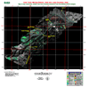
frontispiece |
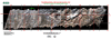
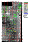
Landsat 7 ETM+ true-color composite, Tintic mining district, Utah |
 |
|---|---|---|
1 |
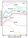
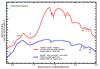
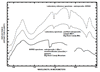
Reflectance spectra of minerals associated with acid drainage |
 |
2 |
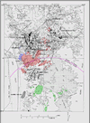
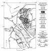
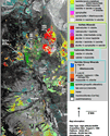
Location map of East Tintic Mountains–Cedar Valley region |
 |
3 |
Location map of Oquirrh Mountains region |
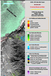
 |
4 |
Location map of Tushar Mountains/Marysvale region |
 |
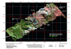
5 |
Location map of low-altitude AVIRIS data coverage over Tintic mining district |
 |
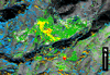
6 |
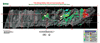
True-color composite image generated from low-altitude AVIRIS flightline over Silver City area and Dragon mine in the Main Tintic subdistrict |
 |
7 |
True-color composite image generated from low-altitude AVIRIS flightline over East Tintic subdistrict |
 |
8 |
False-color composite image generated from low-altitude AVIRIS flightline over Big Rock Candy Mountain area of the Marysvale volcanic field |
 |
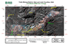
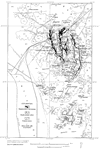
9 |
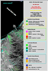
Geologic map of the Tintic mining district |
 |
10 |
Explanation for geologic map shown in figure 9 |
 |
11 |
Map of Main Tintic subdistrict showing mines and plan views of ore bodies |
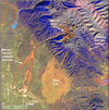
 |
12 |
Map of replacement ore bodies, showing generalized compositional zonation |
 |
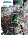
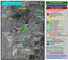
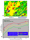
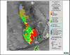
13 |
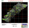
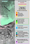
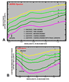
Map of iron-bearing minerals and water in East Tintic Mountains and Tintic mining district, generated from high-altitude AVIRIS data |
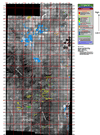 |
14 |
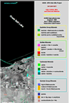
Map of clay, carbonate, sulfate, and mica minerals in East Tintic Mountains and Tintic mining district, generated from high-altitude AVIRIS data |
 |
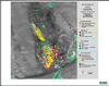
15 |
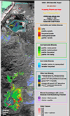
Map of iron-bearing minerals and water in Silver City–Dragon mine area, Main Tintic subdistrict, generated from low-altitude AVIRIS data |
 |
16 |
Map of clay, carbonate, sulfate, and mica minerals in Silver City–Dragon mine area, Main Tintic subdistrict, generated from low-altitude AVIRIS data |
 |
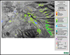
17 |
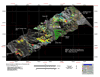
Map of iron-bearing minerals and water in East Tintic subdistrict, generated from low-altitude AVIRIS data |
 |
18 |
Map of clay, carbonate, sulfate, and mica minerals in East Tintic subdistrict, generated from low-altitude AVIRIS data |
 |
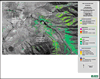
19 |
Subset of map of iron-bearing minerals and water derived from analysis of high-altitude 1998 AVIRIS data |
 |
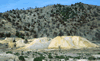
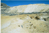
20 |
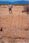
Waste-rock piles with yellowish and yellow-green coatings of jarosite at the Swansea mine site near Silver City |
 |
21
|
True-color composite image of Dragon halloysite mine produced from low-altitude AVIRIS data |
 |
22
|
Detail of map of iron-bearing minerals at the Dragon mine produced from low-altitude AVIRIS data |
 |
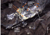
23
|
Pyrite-bearing waste rock in the central section of the Dragon mine |
 |
24 |
Spectral minitransect across waste-rock piles in the central section of the Dragon mine |
 |
25
|
Average low-altitude AVIRIS spectra from minitransect across waste-rock piles at the Dragon mine |
 |
26 |
Landsat 7 ETM+ color composite (741/RGB) of East Tintic Mountains |
 |
27 |
Subset of map of clay, carbonate, sulfate, and mica minerals derived from analysis of high-altitude 1998 AVIRIS data |
 |
28 |
Overlays of faults and fractures on mineral maps derived from spectral analysis of high-altitude AVIRIS data |
 |
29
|
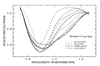
Laboratory spectra of jarosites associated with unmined argillic alteration and anthropogenic, pyrite-bearing mine waste from the Dragon mine |
 |
30 |
Generalized geologic map of Oquirrh Mountains |
 |
31 |
Map of iron-bearing minerals and water in western Oquirrh Mountains, generated from run 7 of high-altitude AVIRIS data |
 |
32 |
Map of clay, carbonate, sulfate, and mica minerals in western Oquirrh Mountains, generated from run 7 of high-altitude AVIRIS data |
 |
33 |
Map of iron-bearing minerals and water in central Oquirrh Mountains, generated from run 9 of high-altitude AVIRIS data |
 |
34 |
Map of clay, carbonate, sulfate, and mica minerals in central Oquirrh Mountains, generated from run 9 of high-altitude AVIRIS data |
 |
35 |
Map of iron-bearing minerals and water in eastern Oquirrh Mountains, generated from run 6 of high-altitude AVIRIS data |
 |
36 |
Map of clay, carbonate, sulfate, and mica minerals in eastern Oquirrh Mountains, generated from run 6 of high-altitude AVIRIS data |
 |
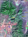
37 |
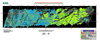
Landsat 7 ETM+ continuous-tone map of mineral groups and vegetation centered on southern Oquirrh Mountains |
 |
38
|
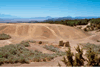
Tailings in the Mercur Canyon outwash, Rush Valley |
 |
39
|
Tailings at the remains of the ore-processing mill in Manning Canyon, southeastern Oquirrh Mountains |
 |
40
|
Tailings extending down-gradient toward the southeast from the mill site in Manning Canyon, southeastern Oquirrh Mountains |
 |
41
|
Open-pit clay mine in Clay Canyon, southern Oquirrh Mountains |
 |
42
|
Pyrite-bearing tailings and other waste at the site of the Bauer Mill near Stockton |
 |
43 |
Enlargement of map of iron-bearing minerals and water over the site of the Bauer Mill near Stockton |
 |
44 |
Enlargement of map of clay, carbonate, sulfate, and mica minerals over the site of the Bauer Mill near Stockton |
 |
45 |
Enlargement of map of iron-bearing minerals and water over the International Smelter and Refining site east of Tooele |
 |
46 |
Enlargement of map of clay, carbonate, sulfate, and mica minerals over the International Smelter and Refining site east of Tooele |
 |
47 |
Landsat 7 ETM+ continuous-tone map of mineral groups and vegetation centered on the Antelope Range several kilometers north of Marysvale |
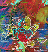 |
48 |
Map of iron-bearing minerals in central Tushar Mountains, generated from run 11 of high-altitude AVIRIS data |
 |
49 |
Map of clay, carbonate, sulfate, mica, and hydrous silica minerals in central Tushar Mountains, generated from run 11 of high-altitude AVIRIS data |
 |
50 |
Map of iron-bearing minerals and water in eastern Tushar Mountains and Antelope Range, generated from run 10 of high-altitude AVIRIS data |
 |
51 |
Map of clay, carbonate, sulfate, mica, and hydrous silica minerals in eastern Tushar Mountains and Antelope Range, generated from run 10 of high-altitude AVIRIS data |
 |
52 |
Map of iron-bearing minerals and water in Big Rock Candy Mountain area of Marysvale volcanic field, produced from low-altitude AVIRIS data |
 |
53 |
Map of clay, carbonate, sulfate, and mica minerals in Big Rock Candy Mountain area of Marysvale volcanic field, produced from the low-altitude AVIRIS data |
 |
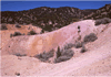
54
|
View of area from which uranium was extracted, looking east toward Jungfrau Peak with goethite-coated waste-rock piles in foreground |
 |
55 |
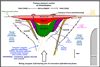
Genetic model for replacement alunite deposits, Antelope Range, Marysvale volcanic field |
 |
56 |
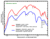
Laboratory spectra of jarosite-bearing rocks formed by hypogene and supergene processes |
 |
57 |
Spectra of natrojarosite from Big Rock Candy Mountain and the reference library |
 |
58
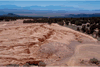
|
View of Big Rock Candy Mountain looking south along Marysvale Canyon |
 |
59
|
View of Marysvale Canyon looking north from the top of Big Rock Candy Mountain |
 |
60 |
Hematite grain-size series |
 |
61 |
Goethite grain-size series |
 |
Part or all of this report is presented in Portable Document Format (PDF); the latest version of Adobe Acrobat Reader or similar software is required to view it. Download the latest version of Acrobat Reader, free of charge or go to access.adobe.com for free tools that allow visually impaired users to read PDF files.
