


The purpose of these interpretive discussions is to provide a perspective on regional- and national-scale variations in element and mineral distributions in soils and their likely causes. The significant spatial variations shown by most elements and minerals can commonly be attributed to geologic sources in underlying parent materials, but other spatial variations seem clearly related to additional factors such as climate, the age of soils, transported source material, and anthropogenic influences. We attempt to distinguish the influence of these various factors on a regional and national scale. Numerous more local features might similarly be related to these same factors, but these features also have some probability of being an artifact of a random sampling of variable compositions, so that there is some probability of samples with similar compositions occurring in clusters of two or more adjacent sites by chance. Distinguishing such random occurrences from true variability is beyond the scope of the data from which these maps are constructed. Some caution, therefore, is advisable in interpreting the significance of these more local features unless some unique sources or processes can clearly be related to them.
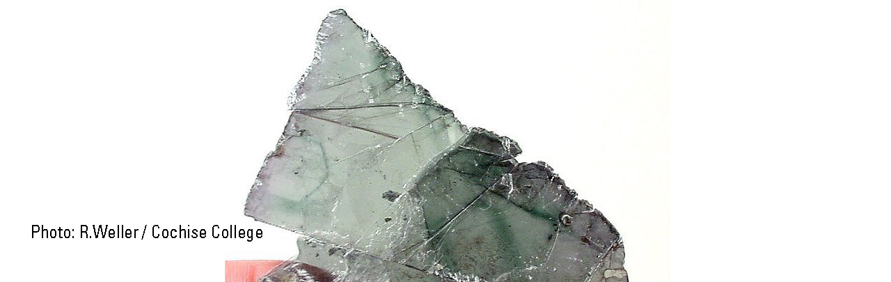
Clay minerals in the 14 Å (1Å (angstrom) = 10–10 meters (m)) group are those that have an interatomic spacing across their principal parting direction of 14 Å or somewhat greater. They are hydrous aluminosilicate minerals with varying concentrations of the major elements iron (Fe), magnesium (Mg), calcium (Ca), and sodium (Na), as well as many trace elements. The distribution of 14 Å clay minerals is important in influencing soil chemistry for these elements For our quantification calculations, we have used crystal structures for the minerals clinochlore ((Mg,Fe+2,Al)3(Si,Al)2O5(OH)4) and vermiculite ((Mg,Fe,Al)3(Al,Si)4O10(OH)2•4H2O). Other minerals that have basal spacing at about 14 Å are montmorillonite and mixed-layer clays. These, however, lack crystal structure data and were not quantified during this study. More detailed studies can provide more definitive identifications of individual minerals, but such studies were beyond the scope and timing of this survey.
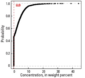
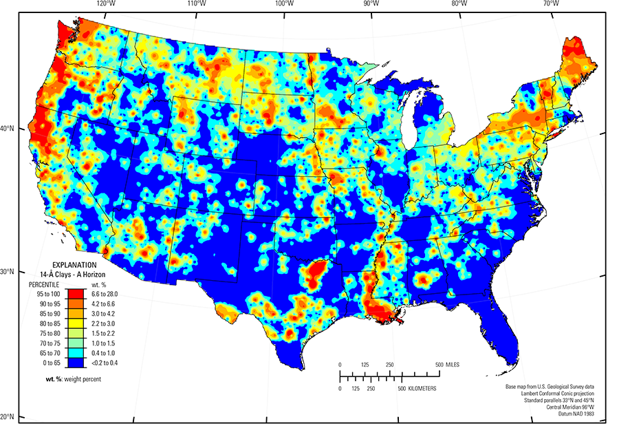
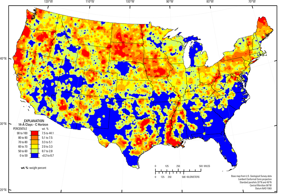
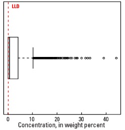
Fourteen angstrom clays do not occur universally across the country. They were detected in only 53 percent of samples from the soil C horizon and 38 percent of samples from the soil A horizon. Median 14 Å clay concentrations are below the 0.2 weight percent (wt. %) lower limit of detection for the soil A horizon and only 0.7 wt. % for the soil C horizon. The concentration of 14 Å clays is highly variable on a national scale and can be as much as 28 wt. % for the soil A horizon and 44 wt. % for the soil C horizon (see the summary statistics [open in new window]). Because of the large percentage of samples lacking identifiable 14 Å clays, the maps are color–coded into six concentration classes for the soil C horizon and eight classes for the soil A horizon.
The most prominent area of high 14 Å clay concentrations in the soil C horizon occurs over soil parent materials that are dominantly shale or clay–rich till in North Dakota and South Dakota. Within the shale formations, interbeds of volcanic ash are altered to smectite, which probably contributes to the clay concentration of some areas. Another area of high 14 Å clay concentrations is along the Mississippi Alluvial Plain (Fenneman and Johnson, 1946). Soils in that area developed on fine–grained clayey sediments of both the modern and ancient Mississippi River floodplain and have been shown in many previous studies to be rich in montmorillonite. Narrow belts of 14 Å clay enrichments in Texas, Mississippi, and Alabama are along the Blackland Prairies (USDA, 2006). These are belts of calcareous clay, marl, and chalk within the Gulf of Mexico Coastal Plain (Fenneman and Johnson, 1946) sediments and are the principal agricultural belts of those States. A belt of high 14 Å clay concentrations is along the Pacific Coast in California, Oregon, and Washington. This is an area of high rainfall that is mostly heavily forested. Underlying geologic materials are a mixture of sedimentary and volcanic rocks and younger alluvium derived from them. The combination of source material, climate, and land cover may be conducive to development of 14 Å clays in that region.
Statistics - 0 TO 5 CM
Statistics - A Horizon
| Number of samples | 4,802 |
| LLD | 0.2 wt. % |
| Number below LLD | 3,042 |
| Minimum | <0.2 wt. % |
| 5 percentile | <0.2 wt. % |
| 25 percentile | <0.2 wt. % |
| 50 percentile | <0.2 wt. % |
| 75 percentile | 1.5 wt. % |
| 95 percentile | 6.6 wt. % |
| Maximum | 28 wt. % |
| MAD | |
| Robust CV |
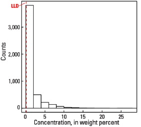
Histogram
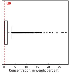
Boxplot
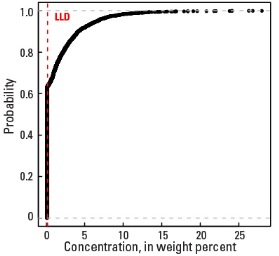
Empirical cumulative distribution function
Statistics - C Horizon
| Number of samples | 4,773 |
| LLD | 0.2 wt. % |
| Number below LLD | 2,237 |
| Minimum | <0.2 wt. % |
| 5 percentile | <0.2 wt. % |
| 25 percentile | <0.2 wt. % |
| 50 percentile | 0.7 wt. % |
| 75 percentile | 4.2 wt. % |
| 95 percentile | 9.6 wt. % |
| Maximum | 44.1 wt. % |
| MAD | |
| Robust CV |
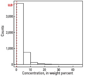
Histogram
Boxplot