U.S. Geological Survey Data Series 542
Publications are available from USGS Information Services, Box 25286, Federal Center, Denver, CO 80225-0046 (telephone 1-888-ASK-USGS; email: info services@usgs.gov).
Contents:Information StatementSystem RequirementsProject SummaryDisc OrganizationAcknowledgmentsReferences Cited |
|||
 |
|||
This DVD publication was prepared by an agency of the United States Government. Although these data have been processed successfully on a computer system at the U.S. Geological Survey, no warranty expressed or implied is made regarding the display or utility of the data on any other system, nor shall the act of distribution imply any such warranty. The U.S. Geological Survey shall not be held liable for improper or incorrect use of the data described and (or) contained herein. Reference herein to any specific commercial product, process, or service by trade name, trademark, manufacturer, or otherwise does not constitute or imply its endorsement, recommendation, or favoring by the United States Government or any agency thereof.
This disc is readable on any computing platform that has standard DVD driver software installed. The minimum software requirements are a Web browser, Adobe Reader, and a text editor. If you cannot fully access the information on these pages, please contact U.S. Geological Survey Information Services at info services@usgs.gov or 1-888-ASK-USGS. NOTE: The only supported Web browsers that properly display all features of the interactive map pages, linking core locations to information about the selected core in the data table, are Internet Explorer 6 or greater for Windows and Firefox 1.5 or greater for all platforms. Additionally, the Google platform can display Microsoft Word and Microsoft Excel files using Google Docs (http://docs.google.com). Please follow links to the Software page for additional software requirements, processing software for digitized core logs, and links to free and trial software downloads.
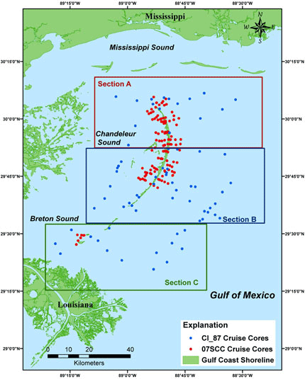
In 2006 and 2007, the U.S. Geological Survey (USGS) and collaborators at the University of New Orleans (UNO) collected high-resolution seismic profiles and subsurface cores around the Chandeleur and Breton Islands, Louisiana (Study Area Map). To ground-truth the acoustic seismic surveys conducted in 2006, 124 vibracores were acquired during the 07SCC04 and 07SCC05 cruises in 2007. These cores were collected within the back-barrier, nearshore, and offshore environments. The surveys were conducted as part of a post-hurricane assessment and sediment resource inventory for the Barrier Island Coastal Monitoring (BICM) project. Vibracores were collected offshore using the USGS R/V G.K. Gilbert, while the terrestrial, back-barrier, and nearshore vibracores were collected from the UNO R/V Greenhead.
This report serves as an archive of sediment data from two concurrent vibracore surveys (cruises 07SCC04 and 07SCC05) from around the Breton and Chandeleur Islands in 2007 and also documents sediment data from vibracores collected offshore of the Chandeleur Islands in 1987 (cruise 87039). The 1987 vibracores were collected through the collaborated efforts of the USGS, Louisiana Geological Survey (LGS), and Alpine Ocean Seismic. Each vibracore can be identified by cruise and core number. The naming convention used for each core is as follows: yyabc##, where 'yy' are the last two digits of the year in which the core was collected, 'abc' is a 2- or 3-letter abbreviation for the cruise location or project type (for example, BI for Breton Island or SCC for Subsidence and Coastal Change), and '##' is a 2-digit number representing a specific core. Vibracores collected by the USGS R/V G.K. Gilbert (cruise 07SCC04) are identified by 07SCC## and offshore Breton Island, 07BI##. The terrestrial, back-barrier, and nearshore vibracores collected from the R/V Greenhead (cruise 07SCC05) are identified as 07SCC_##Gh. For 07SCC05 vibracores, the identifier is modified with '_##dd', the 'dd' being a two-letter abbreviation representing the research vessel from which the core was taken. Vibracores collected in 1987 are identified by a similar naming convention 'ab_yy_##'; these offshore vibracores collected from cruise 87039 are identified as CI_87_##.
Note: The USGS St. Petersburg Coastal and Marine Science Center (SPC&MSC) (St. Petersburg, FL) assigns a unique identifier to each cruises or field activity. For example, 07SCC04 designates the year the data were collected (2007) for the Subsidence and Coastal Change (SCC) cruise identifier, and the field activity number (04) denotes the fourth SCC field activity of the year. Similarly, 87039 is a USGS Woods Hole Coastal and Marine Science Center (Woods Hole, MA) identifier that designates the year (1987) and cruise or field activity number (039). Refer to http://walrus.wr.usgs.gov/infobank/programs/html/definition/activity.html for a detailed description of the method used to assign the cruise ID. More information for each survey can be found in the Field Activity Collection System (FACS) logs and scanned observer's logbooks (Field Logs), as well as in the formal Federal Geographic Data Committee (FGDC) Metadata.
Note: Please refer to the Acronyms page for explanation of all acronyms and abbreviations used in this report. The data files are in Microsoft Word (DOC), Microsoft Excel (XLS), Adobe Acrobat (PDF), Graphics Interchange Format (GIF), Joint Photographic Experts Group (JPEG), and text file (TXT) formats. To access these data files, additional commercial or public domain software such as Microsoft Office (DOC, XLS), Adobe Reader (free software for viewing PDF files), a text editor (TXT), or image preview application (GIF, JPEG) (commonly provided with operating systems) is required; Microsoft Office (DOC, XLS) and Adobe Reader (PDF) files may also be viewed online with free Google Docs. Information on PDF accessibility may be viewed at the Adobe Accessibility Resource Center. Please refer the Software page for more information.
The 07SCC04 and 07SCC05 core locations were selected to ground-truth stratigraphic interpretations from seismic profiles acquired during previous surveys (Baldwin and others, 2009; Twichell and others, 2009) and to directly sample stratigraphic variation in the study area (Flocks and others, 2009). Two similar types of vibracore systems were used to collect the 07SCC04 and 07SCC05 vibracores: 6.1- and 9.1-meters-long aluminum core barrels were vibrated into the sediment using either a Rossfelder model P-3 electric motor (cruise 07SCC04 aboard the R/V G.K. Gilbert) or a Stow G-500 gas motor (cruise 07SCC05 aboard the R/V Greenhead). A detailed description of the vibracoring process is given in the Methods section. The vibracores collected during the 87039 survey were taken by Alpine Ocean Seismic using a 12-m-long Alpine pneumatic vibracore apparatus (Kindinger and others, 1989, 1991; Brooks and others, 1995). For more information refer to the FACS logs or contact Alpine Ocean Seismic.
The sediment data collection, description, and analysis procedures are outlined in the Methods section of this report. The data are presented in the Core Description Sheets, Digitized Core Logs, Grain-Size Data, and Core Photographs sections and are summarized in the Core Data Table. This table includes data from all cruises and can be accessed from the Core Data Table links at the top and bottom of each page, as well as from the Study Area Map. Clicking on a core location or core ID from the Study Area Map pages will link to the Core Data Table and will display the data for that specific core. Synopses of the sediment data section types are as follows: The core description sheets are visual interpretation logs describing sedimentary texture, structures, physical characteristics, and sample location information. The digitized core logs are the digitized versions of the core description sheets. Core photographs are available for the 07SCC04 and 07SCC05 vibracores as 40-cm sections for the entire length of the core. Grain-size analysis was performed on sub-samples for the 07SCC04 and 07SCC05 vibracores, and additional samples were taken from the top and bottom of sand-rich intervals greater than approximately 60-cm thick to allow for more effective textural classification of sandy sedimentary deposits. Additional cruise-specific information is listed on the Core Data Table; however, please check each specific sediment data section for a list of missing data for each cruise (for example: Digitized Core Logs).
The Disc Contents page diagrams the organizational structure of this disc and provides links to the locations of all files and folders contained on this disc. View the Readme file or the Disc Contents page for more information. This report is divided into 13 sections; links at the top and bottom of each page provide access to these sections. This report contains links to the U.S. Geological Survey and collaborators or other resources that are only accessible if access to the Internet is available while viewing these documents.
The USGS Coastal and Marine Geology Program (St. Petersburg, FL, and Woods Hole, MA) and the University of New Orleans provided funding, the 1987 cruise report, and 2007 field support for the collection and analysis of sediment data archived in this report. Additional funding was provided by the U.S. Fish and Wildlife Service (FWS) and the Louisiana Department of Natural Resources (LDNR). We thank R/V G.K. Gilbert captain Keith Ludwig (USGS, St. Petersburg, FL) for assistance in data collection. Kyle Kelso (Jacobs Technology Inc., St. Petersburg, FL) prepared the ArcGIS and map files used in this report. This document was improved through reviews by Arnell Harrison and Julie Bernier (USGS, St. Petersburg, FL).
Brooks, G.R., Kindinger, J.L., Penland, S., Williams, S.J., and McBride, R.A., 1995, East Louisiana continental shelf sediments: A product of delta reworking, Journal of Coastal Research, v. 11 no. 4, p. 1026-1036.
Baldwin, W.E., Pendleton, E.A., and Twichell, D.C., 2009, Geophysical data from offshore of the Chandeleur Islands, Eastern Mississippi Delta, U.S. Geological Survey Open-File Report 2008-1195. (Available at http://woodshole.er.usgs.gov/pubs/of2008-1195/)
Dreher, C.A., Flocks, J.G., Ferina, N.F., and Kulp, M.A., 2008, Archive of sediment-vibracore data collected from Sandy Point to Belle Pass, Louisiana, 1983 through 2000 (Vibracore surveys: 00SCC, CR83, and P86): U.S. Geological Survey Data Series 344. (Available at https://pubs.usgs.gov/ds/344/)
Flocks, J.G., 2004, Converting analog interpretative data to digital formats for use in database and GIS applications: U.S. Geological Survey Open-File Report, 2004-1070. (Available at https://pubs.usgs.gov/of/2004/1070/)
Flocks, J.G., 2008, Directions for converting analog sediment core description sheets to digital spreadsheet format Microsoft Excel macro digitizing program and accompanying text available in Programs Data directory, 16 p. in Dreher, C.A., Flocks, J.G., Ferina, N.F., and Kulp, M.A., 2008, Archive of sediment-vibracore data collected from Sandy Point to Belle Pass, Louisiana, 1983 through 2000 (Vibracore surveys: 00SCC, CR83, and P86): U.S. Geological Survey Data Series 344. (Available at https://pubs.usgs.gov/ds/344/)
Flocks, James, Twichell, David, Sanford, Jordan, Pendleton, Elizabeth, and Baldwin, Wayne, 2009, Sediment sampling analysis to define quality of sand resources, in Lavoie, Dawn, ed., Chapter F of Sand resources, regional geology, and coastal processes of the Chandeleur Islands coastal system: An evaluation of the Breton National Wildlife Refuge: U.S. Geological Survey, Scientific Information Report 2009-5252, p. 99-121.
Folk, R.L., 1968, Petrology of sedimentary rocks: Austin, TX, University of Texas Press,
Hobson, R.D., 1979, Definition and use of the phi grade scale: U.S. Army Corp of Engineers Coastal Engineering Research Center, Coastal Engineering Technical Aid No. 79-7,
Inman, D.L., 1952, Measures for describing the size distribution of sediments: Journal of Sedimentary Petrology, v. 22, no. 3, p. 175-188.
Kindinger, Jack, Flocks, James, Kulp, Mark, and Penland, Shea, 2001, Sand resources, regional geology, and coastal processes for the restoration of the Barataria Barrier shoreline: U.S. Geological Survey Open-File Report 01-384,
Kindinger, J.L., Penland, S., Williams, S.J., Brooks, G.R., Suter, J.R., and McBride, R.A., 1991, Late quaternary geologic framework, North-central Gulf of Mexico: Coastal Sediments '91, v. 1, p. 1096-1110.
Kindinger, J.L., Penland, S., Williams, S.J., and Suter, J.R., 1989, Inner shelf deposits of the Louisiana-Mississippi-Alabama region, Gulf of Mexico: Gulf Coast Association of Geological Societies, 39th Annual Meeting; and Gulf Coast Section SEPM, 36th Annual Meeting; Transactions - Gulf Coast Association of Geological Societies, v. 39, p. 413-420.
Krumbein, W.C., 1938, Size frequency distribution of sediments and the phi normal curve: Journal of Sedimentary Petrology, v. 18, p. 84-90.
Twichell, David, Pendleton, Elizabeth, Baldwin, Wayne, and Flocks, James, 2009, Geologic mapping of distribution and volume of potential resources, in Lavoie, Dawn, ed., Chapter E of Sand resources, regional geology, and coastal processes of the Chandeleur Islands coastal system: An evaluation of the Breton National Wildlife Refuge: U.S. Geological Survey, Scientific Information Report 2009-5252, p. 75-95.
USACE, 1977, Shore protection manual (3rd ed.): Vicksburg, MS, U.S. Army Corp of Engineers, Coastal Engineering Research Center, v. II, p. 1-59.
Wentworth, C.K., 1922, A scale of grade and class terms for clastic sediments: Journal of Geology, v. 30, p. 377-392.

![]() U.S. Department of the Interior |
U.S. Geological Survey
U.S. Department of the Interior |
U.S. Geological Survey
URL: pubs.usgs.gov/ds/542/
Page Contact Information: Feedback
Page Last Modified: Tuesday, 12-October-2010 3:00 PM EST
