| |  |  | | Lake Pontchartrain Atlas: | | | | | | | | | | | | | Environmental Overview |  | | | | | | | | | | | | | | | | | | | | | | | | | | | | | | | |  | | | | | | | | | | |  | Environmental Overview - Regional Description of the Lake Pontchartrain Basin Contributors: Penland, McCarty, Beall, Maygarden The geologic history of the Lake Pontchartrain Basin begins about 20,000 years ago in the Pleistocene Epoch during the late Wisconsin glaciation, when continental and alpine glaciers covered a majority of the North American continent (Sibrava et al., 1986). At that time, sea level was at a lowstand with an elevation approximately 91 m (300 ft) lower than present. Coastal plain rivers were incising their valleys with their channels discharging at the outer edge of the continental shelf. As the late Wisconsin glaciers began to melt 18,000 years ago, sea level began to rise and the Holocene Transgression ensued. As sea level rose, the incised river valleys flooded and the shoreline shoreface eroded into and beveled these Pleistocene uplands. Sea level rose rapidly and continued to rise until the Holocene Transgression ended about 3,000-4,000 years ago. 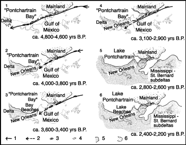 | | Figure 4: Development of Pine Island Barrier Trend (Otvos, 1978). | When the rise in sea level ended and the highstand was achieved, a barrier island system developed and extended from what is today Hancock County, Mississippi east across a shallow embayment to the present location of New Orleans (Otvos, 1978). Geologists refer to this barrier island system as the Pine Island barrier trend (Saucier, 1994). The first stage in formation of the Lake Pontchartrain Basin was the achievement of the highstand 3,000-4,000 years ago, followed by the development of the Pine Island barrier shoreline trend which resulted in the formation of Lakes Maurepas and Pontchartrain (Figure 4). The next stage in the formation of the Lake Pontchartrain Basin was when the St. Bernard delta complex of the Mississippi River Deltaic Plain built out of the alluvial valley onto the continental shelf about 3,000-4,000 years ago (Frazier, 1967). The northern boundary of the St. Bernard delta complex coincided with the south shore of the modern-day Lake Pontchartrain. The St. Bernard delta complex buried the Pine Island barrier island trend under a sequence of deltaic sediments. About 2,000 years ago, the Mississippi River abandoned the St. Bernard delta complex and diverted out of the Basin to the new location of the Lafourche delta complex. This stage in the development of the Basin saw the natural transgression of the St. Bernard delta complex, as coastal land loss began to occur and the Chandeleur Islands started to form approximately 2,000 years ago (Penland et al., 1988; Ritchie et al., 1992). The Mississippi River moved back into the Basin about 1,000 years ago by diverting from the Lafourche delta complex to the Modern delta complex in the southern region of the Basin, completing the development of this magnificent estuarine ecosystem. « Previous | Next » |
