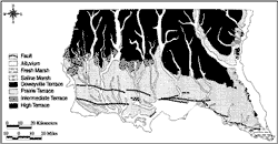
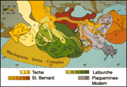
| |  |  | | Lake Pontchartrain Atlas: | | | | | | | | | | | | | Environmental Overview |  | | | | | | | | | | | | | | | | | | | | | | | | | | | | | | | |  | | | | | | | | | | |  | Environmental Overview - Regional Description of the Lake Pontchartrain Basin Contributors: Penland, McCarty, Beall, Maygarden 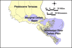 | | Figure 5: Geomorphic regions of Lake Pontchartrain Basin. | | | | | | The Lake Pontchartrain Basin can be divided into three distinct geomorphic regions (Figure 5). First is the Pleistocene Terraces Region that lies north of Lakes Maurepas, Pontchartrain and Borgne. To the south of these lakes lies the Mississippi River Deltaic Plain Region. Separating these two geomorphic regions, Lakes Maurepas, Pontchartrain and Borgne represent the Marginal Deltaic Basin Region where fresh water from coastal plain rivers and salt water of the Gulf of Mexico mix, creating an estuary with a decreasing salinity gradient from east to west through the Basin. Included in this Region are the wetlands surrounding the lakes. The terraces of the Florida Parishes north of the lakes are Pleistocene and older in age (Figure 6). The term 'terrace' implies a surface of common elevation or dip bounded on one side by a steeper ascending slope and on the opposite side by a steeper descending slope. The Florida Parish terrace system can be divided into four terraces. From the oldest (northernmost) to the youngest (southernmost), these are called the High, Intermediate, Prairie and Deweyville terraces. The older and higher terraces have greater relief and the coastal plain streams have a greater incision due to the greater time available for weathering and channel incision. To the south, the St. Bernard delta complex is composed of a series of smaller delta lobes (Figure 7). From oldest to youngest, these are named Bayous Terre aux Boeufs, Des Families, La Loutre and Sauvage (Frazier, 1967). The largest transgressive barrier island arc in Louisiana and the Gulf of Mexico comprises the Chandeleur Islands, which provide a protected shallow back-barrier sound containing the largest seagrass meadows found on the northern Gulf Coast (Suter et al., 1988). « Previous | Next » |