| |  |  | | Lake Pontchartrain Atlas: | | | | | | | | | | | | | | | | Environmental Status & Trends |  | | | | | | | | | | | | | | | | | | | | | | | | | | | | |  | | | | | | | | | | |  | Environmental Status and Trends - Status and Trends of the Lake Pontchartrain Basin Contributors: Penland, Maygarden, Beall 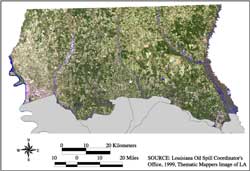 | | Figure 3: Satellite image of Pleistocene Terraces Region. Click on the image for a larger version. | The Pleistocene Terraces region is characterized by its underlying geology of Pleistocene and older sediments, which form terraces of decreasing elevation from north to south (Figure 3). In contrast to the Marginal Deltaic Basin and Mississippi River Deltaic Plain regions, the Pleistocene Terraces region is considered upland and has a distinct relief created by the stream valleys that cut into the underlying sands, gravels and clays. « Previous | Next » |
