| |  |  | | Lake Pontchartrain Atlas: | | | | | | | | | | | | | | | | Environmental Status & Trends |  | | | | | | | | | | | | | | | | | | | | | | | | | | | | |  | | | | | | | | | | |  | Environmental Status and Trends - Status and Trends of the Lake Pontchartrain Basin Contributors: Penland, Maygarden, Beall 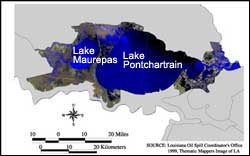 | | Figure 4: Satellite image of Marginal Deltaic Basin Region (Source: Louisiana Oil Spill Coordinator's Office 1999, Landsat Thematic Mapper image of LA). Click on the image for a larger version. | The Marginal Deltaic Basin may be defined as the northern margin of the Mississippi River Deltaic Plain and the lowlands surrounding Lakes Pontchartrain and Maurepas (Figures 4 and 5). It comprises mostly estuarine marshes and forested wetlands of the north, south, east and west shores of Lakes Pontchartrain and Maurepas. Within the Marginal Deltaic Basin are some of the largest remaining tracts of forested wetlands in the Lower Mississippi River Valley and, as such, they provide habitat for an abundance of wildlife. The Marginal Deltaic Basin region is divided into the following eight geo-graphic areas: Maurepas Swamp, Manchac Land Bridge, South West Pontchartrain, Lake Pontchartrain, North Shore Marsh, Bayou Sauvage, East Orleans Land Bridge, and Pearl River Mouth (see Figure 1). The Marginal Deltaic Basin region lies within the coastal zone of Louisiana, and therefore is influenced by many of the same stressors as other regions of the coast; including wetland loss, subsidence, saltwater intrusion and shoreline erosion. The intensity of these factors varies widely within the region. USACE data show a relative sea-level rise in the region of less than 0.15 m (0.5 ft) per century (see Regional Long-Term Relative Sea Level Rise Rates), but; in many localized areas, the rate is greater. Subsidence rates given here for each of the areas in this region are from Coast 2050. Shoreline erosion is taking place around the entire perimeter of Lakes Pontchartrain, Maurepas and Borgne, except for armored sections. The rate of erosion varies and is shown in detail in the Shoreline Change and Shoreline Change Rates section. 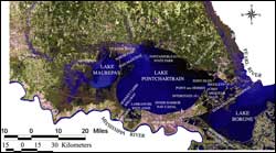 | | Figure 5: Satellite image labeled with the areas and rivers that are mentioned throughout the section for the Marginal Deltaic Basin. Click on the image for a larger version. | The MRGO was completed in 1963 with the purpose of improving shipping access to the Port of New Orleans. Since its completion it has provided a conduit for salt water to enter Lake Pontchartrain. During major tropical storm events, salt water penetrates far into the western regions of the Lake, causing great stress to the freshwater vegetation, including the cypress swamps. Throughout the Twentieth Century, human activities impacted the coastal wetlands. Early in the Twentieth Century, intensive logging operations took place in the forested areas and, as a result, the existing swamp and bottomland forest contains mostly second-growth trees. Since around the 1930's, when cypress logging slowed dramatically, much of the swamp habitat of this region has been allowed to regenerate and it has done so with varying degrees of success. The swamps of the western and southern portions of this region once received overflow from the Mississippi River during flood times, introducing fresh water, sediment and nutrients, which are now lacking due to flood control on the Mississippi. As a result of these measures and continuing natural subsidence, many areas of swamp suffer from changes in the natural conditions to which the vegetation is adapted. For example, due to subsidence, areas of swamp are more likely to be flooded year-round, while the cypress trees depend on seasonal wet and dry periods for successful regeneration. These factors contribute to reduced productivity as well as loss of these habitats. « Previous | Next » |
