| |  |  | | Lake Pontchartrain Atlas: | | | | | | | | | | | | | | | | | | | | | | | | | Basin Geology |  | | | | | | | | | | | | | | | | | | | |  | | | | | | | | | | |  | Basin Geology - Geology Contributors: McCarty, Penland The morphology of the north shore of Lake Pontchartrain in the Goose Point/Point Platte region is commonly referred to as the Bayou Lacombe delta (Figures 2 and 3). However, recent vibracore data (Figures 4 and 5) indicate that this broad expanse of coastal wetlands is not a product of deltaic processes associated with Bayou Lacombe. Instead, the Big Branch wetlands have developed on the shallow platform of the Pleistocene Terrace as it dips below sea level along the north shore of Lake Pontchartrain (Figures 4 and 6). As sea-level rose at the end of the Holocene transgression, the water depth relative to the broad low-gradient Pleistocene surface allowed the formation of one of the largest coastal wetland areas remaining in Lake Pontchartrain. 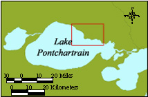 | | Figure 2: Location of Lake Pontchartrain North Shore study area (inset). | | | 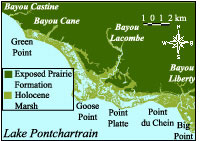 | | Figure 3: Geographic map of the Lake Pontchartrain North Shore study area from Bayou Castine to Big Point. | | The upper Pleistocene sediments in the area consist of firm, compacted fluvial silts and fine fluvial sands of the Prairie Formation that were deposited during the Sangamon Interglacial Age, when sea- level was 6-10 meters (20-32 ft) above present (Otvos, 1972; Autin et al, 1991). The general position of the Goose Point/Point Platte shoreline is delineated by the position of the Baton Rouge fault as mapped by Lopez (1996). The incised areas in the shoreline occupied by Bayous Castine, Cane, Lacombe and Bonfouca/Liberty were cut during the Wisconsin glacial age lowstand. Green Point, Goose Point, Point Platte and Big Point currently serve as erosional headlands. During rising sea-level, these headlands slowly eroded and supplied sand that maintained a beach face, not only at the points but also along the recessed flanks of the shoreline between these points. The beach face protected the backbeach area and allowed the development of the inland marshes and the development of thick peat layers that fill the incisions between the points and inland of the shoreline. The formation of these coastal marshes is dated at 4,365 years ago within the Bayou Lacombe incision and continues today. 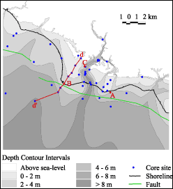 | 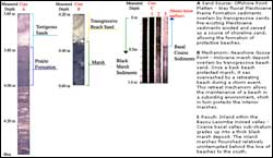 | Figure 4: (Left) Vibracore locations and structure contour map of the Pleistocene surface in the study area. Cores A, B, and C are shown in Figure 5. Cross-section d-d' is shown in Figure 6.
Figure 5: (Above) Three vibracores showing examples of sediments from the primary depositional environments that have constructed the Big Branch Shoreline and Bayou Lacombe areas. Click on the image for a larger version. | 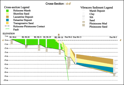 | | Figure 6: Vibracore cross section d-d' showing depositional environments and position of Baton Rouge Fault described by Lopez (1996). | « Previous | Next » |
