
Introduction
 |
 |
|
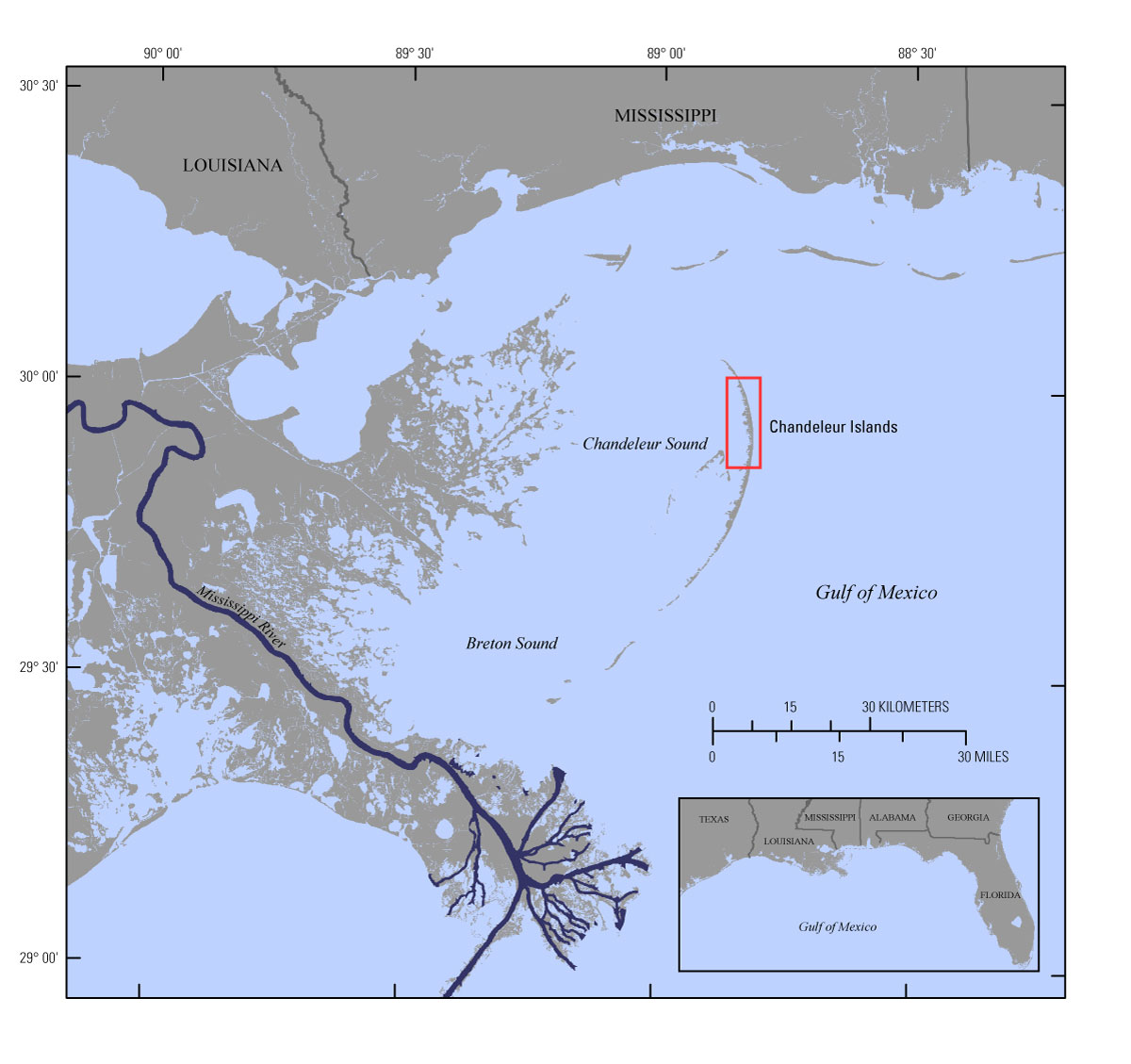
Figure 1. Regional map showing location of the Chandeleur Islands barrier-island chain in the northern Gulf of Mexico. Study-area extent is indicated by red box. Base map modified from USGS 1:100,000-scale Digital Line Graph data. [Click to enlarge] |
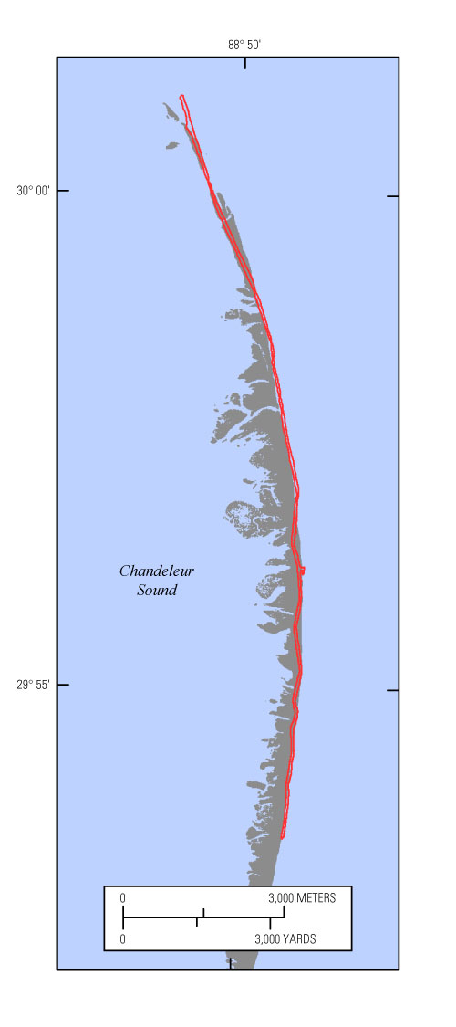
Figure 2. Study-area map showing the maximum as-built extent of the Chandeleur Islands sand berm (in red; Plant and Guy 2013a, b; Plant and Guy, 2014). Island extent is derived from USGS lidar data collected in February 2012 (Guy and others, in press b). [Click to enlarge] |
Located about 40 kilometers (km) east of the Louisiana mainland, the Chandeleur Islands (fig. 1) and the surrounding Breton National Wildlife Refuge provide habitat for several species of sea turtles and migratory and nesting birds, including the endangered piping plover; maintain estuarine conditions in Breton Sound; and function as storm protection for coastal Louisiana, lessening impacts to coastal wetlands and human infrastructure. These barrier islands formed through the subsidence, erosion, and reworking of the deltaic headland of the former St. Bernard Delta complex, which was abandoned between about 2,000 and 1,800 years ago (Rogers and others, 2009; Twichell and others, 2009). In recent decades, the Chandeleur Islands have undergone some of the highest rates of land loss of all northern Gulf of Mexico barrier islands as a result of the combined effects of storm-induced breaching, erosion, and relative sea-level rise (Lavoie, 2009; Kindinger and others, 2013).
Between June 2010 and April 2011, in response to the Deepwater Horizon oil spill, the State of Louisiana constructed a sand berm extending more than 14 km along the northern Chandeleur Islands platform (fig. 2; Lavoie and others, 2010; Plant and Guy, 2013a, b, 2014). The emplacement of this berm provided a unique opportunity to build on an extensive library of previous U.S. Geological Survey (USGS) research that focused on the regional geologic framework and evolution of the Chandeleur Islands and the short-term impacts of extreme storms on this barrier-island system (for example, see Sallenger and others, 2007; Lavoie, 2009; Twichell and others, 2009). As part of the Barrier Island Evolution Research (BIER) project, scientists from the USGS St. Petersburg Coastal and Marine Science Center (SPCMSC) have been monitoring changes along the berm and adjacent barrier-island environments in an effort to understand how this new sediment source will interact with and drive the morphologic evolution of the barrier-island system.
This report describes sediment data that were collected in March and September 2012 from the Chandeleur Islands sand berm and adjacent barrier-island environments. Samples were collected along the length of the berm and from the natural island extending more than 1.5 km south of the berm footprint. Surface samples from along the axis of the berm will be used to analyze the physical characteristics of and spatial differences among berm sediments. Push cores collected along transects across the berm and onto the adjacent barrier island will provide information about sediment interactions and movement between the berm and the natural island platform. Several core and grab sample sites were reoccupied in July 2013; comparison of sediment properties from 2012 and 2013 at these sites will be used to assess how washover and aeolian processes redistribute the berm sediment. Finally, analysis of sediment data from several shallow-water sites that were previously sampled in 2006 and 2008 will enable comparisons of pre- and post-berm physical characteristics.
The data presented in this report, including descriptive core logs, core photographs and x-radiographs, processed grain-size data, and accompanying maps, may be viewed or downloaded from the Data Products and Downloads page. The overall objective of the BIER project is to better understand the depositional and erosional processes that drive the morphologic evolution of barrier islands over annual to interannual timescales (1 to 5 years). This multidisciplinary study addresses a research gap between the very short timescale (hours to days) of storm-induced coastal change and the longer timescales (decades to millennia) associated with historic and geologic evolution of the coastal system. Other data collected from the northern Chandeleur Islands as part of the BIER project include back-barrier marsh and tidal flat sediment data (Marot and others, in press); repeat geophysical surveys including single-beam and swath bathymetry, interferometric backscatter, and sub-bottom seismic data from 2011 (Forde and others, 2013; DeWitt and others, in press b), 2012 (Forde and others, in press; DeWitt and others, in press a), and 2013; and repeat topographic light detection and ranging (lidar) surveys from 2010 to 2013 (Guy and Plant, in press; Guy and others, in press a, b). Previous USGS publications relevant to this study area include Sallenger and others, 2007; Baldwin and others, 2009; Lavoie and others, 2009; Twichell and others, 2009; Dreher and others, 2010; Forde and others, 2010, 2013; Nayegandhi and others, 2010; Guy and others, 2013; Kindinger and others, 2013; and Plant and Guy, 2013a, b, 2014.
