USGS - science for a changing world

Data Series 1031

Project Description - North and Northwest Forks of the Loxahatchee and Lower St. Lucie Rivers (2003)


Figure 26. Project study area - Loxahatchee and St. Lucie Rivers, Florida. [Click on icon for link to data page]

The Loxahatchee River (fig. 26) and estuary is a shallow water body, located in southeastern Florida that empties into the Atlantic Ocean at Jupiter Inlet. The watershed drains an area of more than 520 square kilometers (km2) within northern Palm Beach and southern Martin Counties. Historically, this system was primarily freshwater; however, tidal flows opened the inlet periodically allowing for a mixed environment. In 1947, the inlet was dredged for navigation and has remained permanently open since that time. Drainage patterns within the basin have been significantly altered due to drainage and development, road construction (such as Florida Turnpike, BeeLine Highway), and construction of the C-18 canal which provides flood protection for residential areas.

The St. Lucie estuary and watershed (fig. 26) are located on the southeast coast of Florida in Martin and St. Lucie Counties. The watershed encompasses about 2,020 km2 and is divided into five major basins, which discharge into the Indian River Lagoon and the Atlantic Ocean through the St. Lucie Inlet. The St. Lucie Canal (C-44), along with the Caloosahatchee River (C-43), are important components of the Central and Southern Florida Project and are primarily used for water releases from Lake Okeechobee when lake levels exceed established regulatory requirements of the U.S. Army Corps of Engineers. The C-44 basin is particularly dependent on the lake for supplemental water supply and aquifer recharge.

This project addresses the collection and interpretation of data necessary to develop the present day bathymetry of the Loxahatchee and St. Lucie Rivers (fig. 27). These surveys support several South Florida Water Management District (SFWMD) efforts including the development of minimal flow levels (MFL) for the Loxahatchee and St. Lucie Rivers, and the Indian River Lagoon Feasibility Study. These state-mandated efforts will utilize data obtained from the surveys to develop hydrodynamic models, which are essential in understanding the ecological processes of each of these coastal systems. This project also supports other nonmodeling efforts such as the determination of the oligohaline zones in the St. Lucie River systems.

Color contour map of  North and Northwest Forks of the Loxahatchee River, Florida.

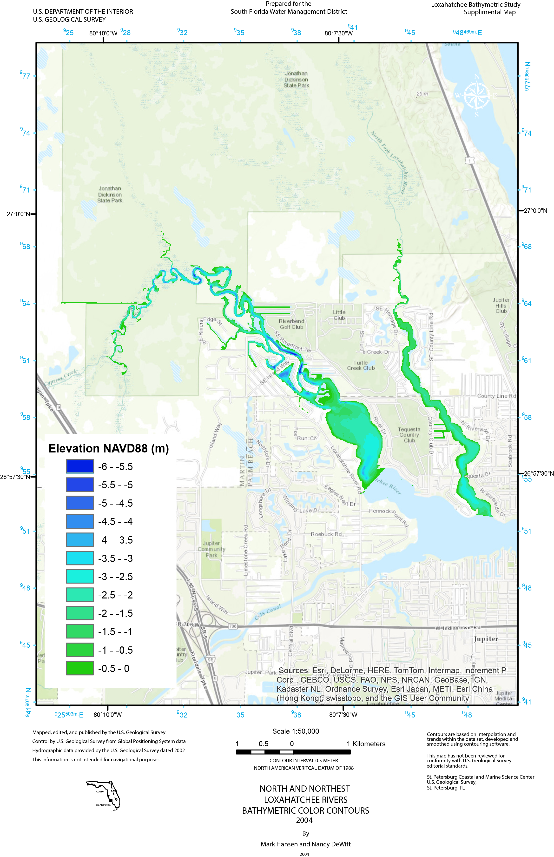
Figure 27. Color contour map of North and Northwest Forks of the Loxahatchee River, Florida. [Click to enlarge]

SURVEY HIGHLIGHTS


  • Area of Coverage The northern sections of the North and Northwest Forks of the Loxahatchee River and Lower St. Lucie River. Water depths ranged from 0.3 to 5.0 meters (m).
  • Survey Date Survey data were collected in 2003.
  • Data and Formats X,Y,Z soundings. Number of soundings: 107,106. Comma-delimited text and ESRI point shapefile.
  • Survey Control All data were processed relative to the WGS84(G1150) ellipsoid. In order to maintain the 15 kilometer (km) guideline, two new monuments were established near the Loxahatchee and St. Lucie Rivers, each being occupied for multiple long-duration (8 hours or greater) sessions. Coordinates of the control locations are listed here. The methodology for establishing new control locations is described in Establishing New Control using GIPSY, SCOUT and OPUS.
  • Accuracy Precise differential GPS was used to determine horizontal and vertical positions. The estimated horizontal and vertical accuracy of the soundings is approximately 6 centimeters (cm) and 8 cm, respectively.

(back to top)

Accessibility FOIA Privacy Policies and Notices

Take Pride in America logo USA.gov logo U.S. Department of the Interior | U.S. Geological Survey
URL: http://pubsdata.usgs.gov/pubs/ds/1031/ds1031_loxa_description.html
Page Contact Information: GS Pubs Web Contact
Page Last Modified: Monday, 24-Jul-2017 11:39:44 EDT