USGS - science for a changing world

Data Series 1037


Sediment Data Collected in 2014 and 2015 From Around Breton and Gosier Islands, Breton National Wildlife Refuge, Louisiana

Skip Links

Citation Page
Abstract
Introduction
Field Data Collection
Laboratory Methods and Analyses
Core Viewer
Abbreviations
References Cited
 

Core Viewer

Locations of sites where cores were collected from around Breton Island in July 2014
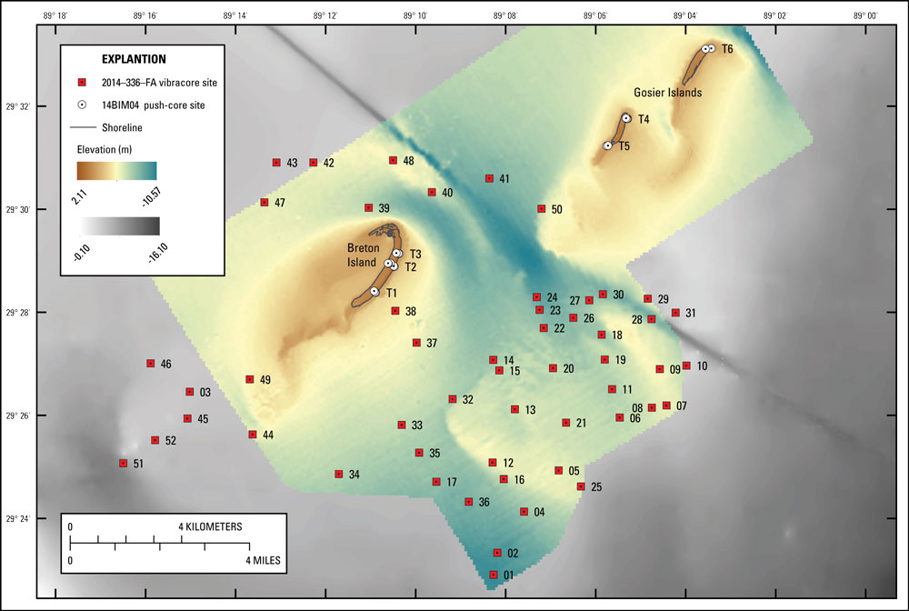
Figure 9. Locations of sites where cores were collected from around Breton Island in July 2014 (Field Activity Number [FAN] 14BIM04) and January 2015 (FAN 2014–336–FA). Basemap derived from USGS bathymetric and lidar data overlaid with National Oceanic and Atmospheric Administration (NOAA) digital elevation model (Love and others, 2010; DeWitt and others, 2016; Terrano and others, 2016b). The channel delineated by deeper depths between Breton and Gosier Islands is the abandoned Mississippi River Gulf Outlet (MRGO). Click on a transect (“T”) or core number to view the core logs for that site. Click here to download map as a printable PDF file.

The sediment data described in this report, including field logs, sample location tables, descriptive core logs, core photographs and x-radiographs, processed grain-size data, and GIS data files with accompanying FGDC metadata, can be downloaded from Bernier and others (2017) or by using the table below. Additionally, the core logs can be viewed by clicking on the transect (push cores) or core number on the sample location map (fig. 9).

Field Activity Collection System (FACS) documents, including scanned handwritten field logs and core logs, are provided in Portable Document Format (PDF) format and can be viewed using the free software Adobe Reader. Digital FACS and field logs were generated from handwritten field notes and logbooks. The core photographs and x-radiographs are provided as high-resolution Joint Photographic Experts Group (JPEG) and TIFF formats, respectively, and can be viewed using standard image viewing software. The sample location tables and grain-size spreadsheets were created in Microsoft Excel 2010 and can be opened using Microsoft Excel 2007 or higher; these data may also be viewed using the free Microsoft Excel Viewer. The sample locations are also provided as comma-separated values text files (.csv) and GIS data files in Esri shapefile (.shp) and Keyhole Markup Language (KML) format; the GIS files can be opened using the free ArcGIS Explorer or Google Earth GIS viewers. All FAN 14BIM04 site locations and GIS data files are referenced to the projected coordinate system North American Datum of 1983 (NAD83), Universal Transverse Mercator (UTM) Zone 16 North (16N); all 2014–336–FA locations and GIS data files are referenced to the projected coordinate system World Geodetic System of 1984 (WGS84), UTM Zone 16N; and all elevations are provided as North American Vertical Datum of 1988 (NAVD88) orthometric heights, derived using the GEOID12A geoid model.

File Name and Description Metadata (XML format) Metadata (text format) Download File
Sediment Data - 14BIM04
14BIM04_samplesites.zip
Sample locations (.xlsx, .csv, .shp, .kml)
14BIM04-met.xml 14BIM04-met.txt 14BIM04_samplesites.zip
(130 KB)
14BIM04_CoreLogs.pdf
Core logs (.pdf)
14BIM04-met.xml 14BIM04-met.txt 14BIM04_CoreLogs.pdf
(5.6 MB)
14BIM04_CorePhotos.zip
Core photographs (.jpg)
14BIM04-met.xml 14BIM04-met.txt 14BIM04_CorePhotos.zip
(77 MB)
14BIM04_CoreXrays.zip
Core x-radiographs (.tiff)
14BIM04-met.xml 14BIM04-met.txt 14BIM04_CoreXrays.zip
(25 MB)
14BIM04_GrainSize_SumStats.zip
Grain size summary statistics (.xlsx, .csv)
14BIM04-met.xml 14BIM04-met.txt 14BIM04_GrainSize_SumStats.zip
(441 KB)
Sediment Data - 2014-336-FA
2014-336-FA_coresites.zip
Sample locations (.xlsx, .csv, .shp, .kml)
2014-336-FA-met.xml 2014-336-FA-met.txt 2014-336-FA_coresites.zip
(95 KB)
2014-336-FA_CoreLogs.pdf
Core logs (.pdf)
2014-336-FA-met.xml 2014-336-FA-met.txt 2014-336-FA_CoreLogs.pdf
(318 MB)
2014-336-FA_CorePhotos.zip
Core photographs (.jpg)
2014-336-FA-met.xml 2014-336-FA-met.txt 2014-336-FA_CorePhotos.zip
(61 MB)
2014-336-FA_GrainSize_SumStats.zip
Grain size summary statistics (.xlsx, .csv)
2014-336-FA-met.xml 2014-336-FA-met.txt 2014-336-FA_GrainSize_SumStats.zip
(1.6 MB)
Supplemental Information
14BIM04_FACS.zip
Field Activity Collection System (FACS) logs and scanned handwritten notes (.pdf)
Not applicable Not applicable 14BIM04_FACS.zip
(7.7 MB)
2014-336-FA_FACS.zip
Field Activity Collection System (FACS) logs and scanned handwritten notes (.pdf)
Not applicable Not applicable 2014-336-FA_FACS.zip
(21 MB)
14BIM04_CoreLogs_handwritten.pdf
Scanned handwritten core logs (.pdf)
Not applicable Not applicable 14BIM04_CoreLogs_handwritten.pdf
(4.7 MB)
2014-336-FA_CoreLogs_handwritten.pdf
Scanned handwritten core logs (.pdf)
Not applicable Not applicable 2014-336-FA_CoreLogs_handwritten.pdf
(12.9 MB)
14BIM04_GrainSize_RunStats.zip
GRADISTAT grain size run statistics (.xlsx)
14BIM04-met.xml 14BIM04-met.txt 14BIM04_GrainSize_RunStats.zip
(3.4 MB)
2014-336-FA_GrainSize_RunStats.zip
GRADISTAT grain size run statistics (.xlsx)
2014-336-FA-met.xml 2014-336-FA-met.txt 2014-336-FA_GrainSize_RunStats.zip
(18 MB)

Accessibility FOIA Privacy Policies and Notices

Take Pride in America logo USA.gov logo U.S. Department of the Interior | U.S. Geological Survey
URL: http://pubsdata.usgs.gov/pubs/ds/1037/ds1037_core-viewer.html
Page Contact Information: GS Pubs Web Contact
Page Last Modified: Wednesday, 26-Apr-2017 09:15:47 EDT

Transect 6Transect 5Transect 4Transect 3Transect 2Transect ICore 26Core 27Core 30Core 23Core 22Core 24Core 15Core 14Core 28Core 29Core 31Core 50Core 41Core 48Core 40Core 39Core 42Core 43Core 47Core 46Core 3Core 45Core 52Core 51Core 49Core 44Core 38Core 37Core 18Core 19Core 9Core 10Core 11Core 8Core 7Core 6Core 20Core 13Core 32Core 33Core 35Core 17Core 34Core 21Core 12Core 16Core 36Core 5Core 25Core 4Core 2 Core 1