Data Series 1037
1U.S. Geological Survey, 2Cherokee Nation Technologies
| Abstract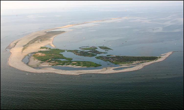 Oblique aerial photograph looking approximately south along Breton Island, July 2013. Photograph by Karen Morgan (Morgan and Westphal, 2014). [Click image to enlarge] Breton Island, located at the southern end of the Chandeleur Islands, supports one of Louisiana’s largest historical brown pelican (Pelecanus occidentalis) nesting colonies. Although the brown pelican was delisted as an endangered species in 2009, nesting areas are threatened by continued land loss and are extremely vulnerable to storm impacts. The U.S. Fish and Wildlife Service proposed to restore Breton Island to pre-Hurricane Katrina conditions through rebuilding the shoreface, dune, and back-barrier marsh environments. Prior to restoration, scientists from the U.S. Geological Survey’s (USGS) St. Petersburg Coastal and Marine Science Center Geologic and Morphologic Evolution of Coastal Margins project collected high-resolution geophysical (topography, bathymetry, and sub-bottom profiles) and sedimentologic data from around Breton Island to characterize the geologic framework of the island platform, nearshore, and shelf environments. These data will be used to characterize the geologic framework around Breton Island, identify potential borrow areas for restoration efforts, quantify seafloor change, and provide information for sediment transport and morphologic change models to assess island response to restoration and natural processes. This report, along with the accompanying USGS data release (Bernier and others, 2017), serves as an archive of sediment data from vibracores, push cores, and submerged grab samples collected from around Breton and Gosier Islands, Louisiana, during two surveys conducted in July 2014 and January 2015 (USGS Field Activity Numbers 2014–314–FA and 2014–336–FA, respectively). Sedimentologic and stratigraphic metrics (for example, sediment texture or unit thicknesses) derived from these data can be used to ground-truth the geophysical data and characterize potential sand resources or can be incorporated into sediment transport or morphologic change models. Data products, including sample location tables, descriptive core logs, core photographs and x-radiographs, results of sediment grain-size analyses, and geographic information system data files with accompanying formal Federal Geographic Data Committee metadata can be downloaded from Bernier and others (2017). NOTE: Any use of trade names is for descriptive purposes only and does not imply endorsement by the U.S. Government. AcknowledgmentsThis project included support from the Louisiana Outer Coast Early Restoration Project, obtained by the natural resource trustees for the Deepwater Horizon Oil Spill, pursuant to the Framework for Early Restoration Addressing Injuries Resulting from the Deepwater Horizon Oil Spill executed April 20, 2011. The authors thank American Vibracore Services and the captain and crew of the M/V Thunderforce and the M/V Southern VI for field and logistical support. Alisha Ellis (U.S. Geological Survey) x-rayed the push cores and Jolene Gittens (U.S. Geological Survey) assisted with the report layout and Web design. We also thank Noreen Buster, Marci Marot, and Arnell Forde (U.S. Geological Survey) for conducting scientific, editorial, and metadata reviews that improved the content and presentation of the report. Suggested CitationBernier, J.C., Kelso, K.W., Tuten, T.M., Stalk, C.A., and Flocks, J.G., 2017, Sediment data collected in 2014 and 2015 from around Breton and Gosier Islands, Breton National Wildlife Refuge, Louisiana: U.S. Geological Survey Data Series 1037, https://doi.org/10.3133/ds1037. Contact
Julie Bernier |

![]() U.S. Department of the Interior |
U.S. Geological Survey
U.S. Department of the Interior |
U.S. Geological Survey
URL: http://pubsdata.usgs.gov/pubs/ds/1037/index.html
Page Contact Information: GS Pubs Web Contact
Page Last Modified: Tuesday, 07-Mar-2017 14:30:27 EST
