Data Series 1037
| IntroductionLocated about 40 kilometers (km; about 25 miles) east of the Louisiana mainland, the Chandeleur Islands (fig. 1) and the surrounding Breton National Wildlife Refuge (BNWR) provide habitat for several species of sea turtles as well as migratory and nesting birds; maintain estuarine conditions in Breton Sound; and function as storm protection for coastal Louisiana, lessening the effects on coastal wetlands and human infrastructure. These barrier islands formed through the subsidence, erosion, and reworking of the deltaic headland of the former St. Bernard Delta complex, which was abandoned between about 2,000 and 1,800 years ago (Rogers and others, 2009; Twichell and others, 2009). In recent decades, the combined effects of reduced sediment supply, frequent storm impacts, and relative sea-level rise have contributed to land loss along the Chandeleur Islands at rates that are among the highest of northern Gulf of Mexico barrier islands (Lavoie, 2009; Kindinger and others, 2013; Terrano and others, 2016a). 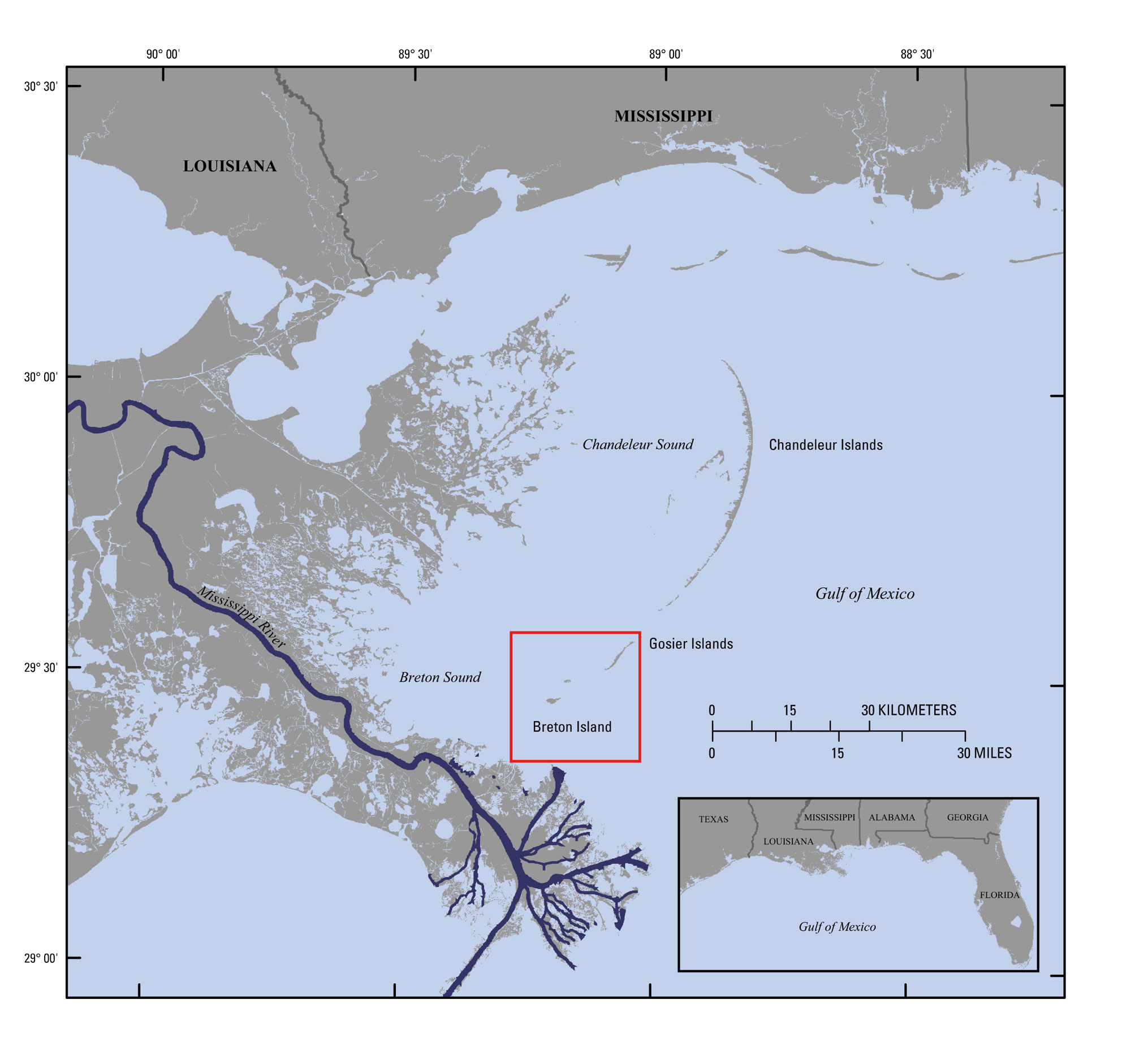 Figure 1. Regional map showing location of the Chandeleur Islands barrier-island chain in the northern Gulf of Mexico. Study-area extent is indicated by red box. Base map modified from U.S. Geological Survey 1:100,000-scale digital line graph data. [Click image to enlarge] Breton Island, located at the southern end of the Chandeleur Islands, supports one of Louisiana’s largest historical brown pelican (Pelecanus occidentalis) nesting colonies (fig. 2). Although the brown pelican was delisted as an endangered species in 2009, nesting areas are threatened by continued land loss and are extremely vulnerable to storm impacts. For example, between 1996 and 2005, the area was affected by multiple storms, including Hurricane Katrina, and land area decreased by more than 80 percent (Martinez and others, 2009; Terrano and others, 2016a). Following Hurricane Katrina, only a small remnant of the pre-Katrina marsh platform at the northern end of Breton Island remained emergent, and Lavoie (2009) predicted that without actions to restore sand to the barrier-island system, Breton Island could be reduced to ephemeral shoals within several decades. Gosier Islands, northeast of Breton Island, are shoals that have been submerged since Hurricane Katrina and have only recently become emergent. Since Hurricane Katrina, fewer, lower intensity storms have affected Breton Island. Since 2008, land area, including vegetated areas that provide nesting habitat for pelicans, has recovered slightly but total land area has not surpassed its pre-Katrina extent (Flocks and Terrano, 2016; Terrano and others, 2016a). The U.S. Fish and Wildlife Service (USFWS) proposed to restore Breton Island to pre-Katrina conditions through rebuilding the shoreface, dune, and back-barrier marsh environments. Prior to restoration, scientists from the U.S. Geological Survey’s (USGS) St. Petersburg Coastal and Marine Science Center (SPCMSC) Geologic and Morphologic Evolution of Coastal Margins project collected high-resolution geophysical (topography, bathymetry, and sub-bottom profiles; DeWitt and others, 2016; Forde and others, 2016; Terrano and others, 2016b) and sedimentologic data from around Breton Island. Data were collected to supplement data that were collected in 2007 (Lavoie, 2009; Dreher and others, 2010; Kindinger and others, 2013), evaluate changes that have occurred since 2007, and characterize the geologic framework of the island platform, nearshore, and shelf environments. These data will be used to identify potential borrow areas for restoration efforts and provide information for sediment transport and morphologic change models to assess island response to restoration and natural processes (Dalyander and others, 2015). This report, along with Bernier and others (2017), serves as an archive of sediment data from vibracores, push cores, and submerged grab samples collected from around Breton and Gosier Islands, Louisiana, during two surveys conducted in July 2014 and January 2015 (USGS Field Activity Numbers [FAN] 2014–314–FA and 2014–336–FA, respectively). Sedimentologic and stratigraphic metrics (for example, sediment texture or unit thicknesses) derived from these data can be used to ground-truth the geophysical data and characterize potential sand resources or can be incorporated into sediment transport or morphologic change models. Data products, including sample location tables, descriptive core logs, core photographs and x-radiographs, results of sediment grain-size analyses, and geographic information system (GIS) data files with accompanying formal Federal Geographic Data Committee (FGDC) metadata can be downloaded from Bernier and others (2017). 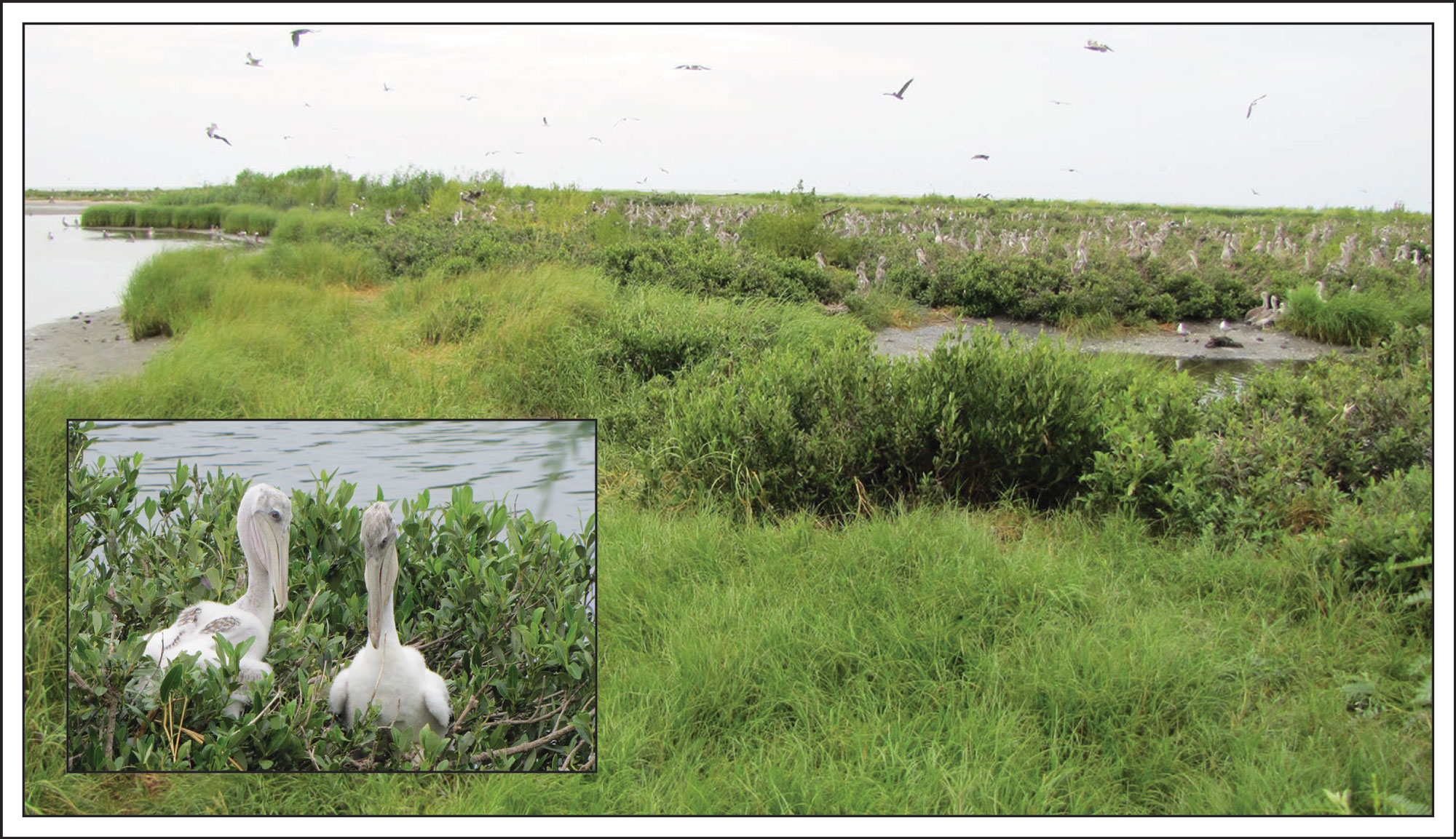 Figure 2. Brown pelican (Pelecanus occidentalis) nesting area on Breton Island, Louisiana. Photographs by Julie Bernier and Nancy DeWitt (U.S. Geological Survey). [Click image to enlarge] |

![]() U.S. Department of the Interior |
U.S. Geological Survey
U.S. Department of the Interior |
U.S. Geological Survey
URL: http://pubsdata.usgs.gov/pubs/ds/1037/ds1037_introduction.html
Page Contact Information: GS Pubs Web Contact
Page Last Modified: Tuesday, 07-Mar-2017 14:30:27 EST
