Data Series 1039
1Cherokee Nation Technologies.
2U.S. Geological Survey.
| Abstract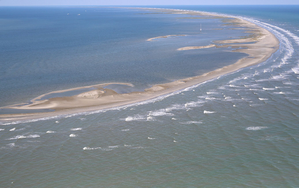 Aerial photograph looking north, along the Chandeleur Islands, Louisiana, taken September 18, 2015. Photograph by Karen Morgan, U.S. Geological Survey (Morgan, 2016). [Click figure to enlarge] As part of the Louisiana Coastal Protection and Restoration Authority (CPRA) Barrier Island Comprehensive Monitoring Program, scientists from the U.S. Geological Survey (USGS) St. Petersburg Coastal and Marine Science Center conducted a single-beam bathymetry survey around the Chandeleur Islands, Louisiana, in June 2015. The goal of the program is to provide long-term data on Louisiana’s barrier islands and use this data to plan, design, evaluate, and maintain current and future barrier island restoration projects. The data described in this report, along with (1) USGS bathymetry data collected in 2013 as a part of the Barrier Island Evolution Research project covering the northern Chandeleur Islands, and (2) data collected in 2014 in collaboration with the Louisiana CPRA Barrier Island Comprehensive Monitoring Program around Breton Island, will be used to assess bathymetric change since 2006‒2007 as well as serve as a bathymetric control in supporting modeling of future changes in response to restoration and storm impacts. The survey area encompasses approximately 435 square kilometers (km2) of nearshore and back-barrier environments around Hewes Point, the Chandeleur Islands, and Curlew and Grand Gosier Shoals. This Data Series serves as an archive of processed single-beam bathymetry data, collected in the nearshore of the Chandeleur Islands, Louisiana, from June 17‒24, 2015, during USGS Field Activity Number 2015-317-FA. Geographic information system data products include a 200-meter-cell-size interpolated bathymetry grid, trackline maps, and xyz point data files. Additional files include error analysis maps, Field Activity Collection System logs, and formal Federal Geographic Data Committee metadata. Note that these data are scientific in nature and are not to be used for navigation purposes. Any use of trade names is for descriptive purposes only and does not imply endorsement by the U.S. Government. AcknowledgmentsFunding for this project was provided through the Barrier Island Coastal Monitoring Program and the State of Louisiana Coastal Protection Restoration Authority. The authors thank Point Cadet Marina and the captain and crew of the Southern VI (Biloxi, Miss.) for use of facilities and logistical support during this survey. We also thank Noreen Buster, Billy Reynolds, Arnell Forde, and Jolene Gittens (U.S. Geological Survey) for conducting scientific, editorial, metadata, and Web design reviews that improved content and presentation of this report. Information StatementThis publication was prepared by an agency of the United States Government. Although these data were processed successfully on a computer system at the U.S. Geological Survey, no warranty expressed or implied is made regarding the display or utility of the data on any other system, or for general or scientific purposes, nor shall the act of distribution imply any such warranty. The U.S. Geological Survey shall not be held liable for improper or incorrect use of the data described and (or) contained herein. Reference herein to any specific commercial product, process, or service by trade name, trademark, manufacturer, or otherwise does not constitute or imply its endorsement, recommendation, or favoring by the United States Government or any agency thereof. Suggested CitationStalk, C.A., DeWitt, N.T., Bernier, J.C., Kindinger, J.G., Flocks, J.G., Miselis, J.L., Locker, S.D., Kelso, K.W., and Tuten, T.M., 2017, Coastal single-beam bathymetry data collected in 2015 from the Chandeleur Islands, Louisiana: U.S. Geological Survey Data Series 1039, https://doi.org/10.3133/ds1039. ContactChelsea A. StalkCherokee Nation Technologies Contracted to the U.S. Geological Survey St. Petersburg Coastal and Marine Science Center 600 4th Street South St. Petersburg, FL 33701 (727) 502-8000 [email protected] |

![]() U.S. Department of the Interior |
U.S. Geological Survey
U.S. Department of the Interior |
U.S. Geological Survey
URL: http://pubsdata.usgs.gov/pubs/ds/1039/index.html
Page Contact Information: GS Pubs Web Contact
Page Last Modified: Friday, 24-Feb-2017 13:09:26 EST
