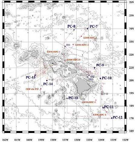
Figure PC1. Locations of piston-core sites during 2001 cruise north of Oahu and south of Hawaii Island (triangles).Square indicates coring location of ODP Leg 136, sites 842 and 843, and KR98-08&09.
4. Piston core
4-0. Summary and Onboard-sampling procedures
| ID | LAT | LONG | Water depth m | area |
| PC-7 | 24° 01.85' N | 155° 05.22' W | 4389 | north of Oahu |
| PC-8 | 23° 05.06' N | 156° 12.29' W | 4354 | north of Oahu |
| PC-9 | 21° 00.01' N | 154° 29.99' W | 5444 | northeast of Hawaii |
| PC-10 | 20° 10.15' N | 154° 00.76' W | 5375 | northeast of Hawaii |
| PC-11 | 17° 51.94' N | 153° 47.24' W | 4947 | southeast of Hawaii |
| PC-12 | 17° 02.25' N | 153° 03.65' W | 5201 | southeast of Hawaii |
| PC-13 | 18° 36.39' N | 156° 47.00' W | 4797 | southwest of Hawaii |
| PC-14 | 20° 00.02' N | 158° 27.99' W | 4344 | south of Oahu |
| PC-15 | 20° 25.42' N | 159° 26.66' W | 4543 | south of Oahu |
Table 1. Piston Core Sampling Positions (WGS849)
4-1. North of Oahu (PC-7 and PC-8)
4-2. Northeast of Hawaii (PC-9 and PC-10)
4-3. Southeast of Hawaii (PC-11and PC-12)
4-4. Southwest of Hawaii (PC-13)
4-5. South of Oahu (PC-14 and PC-15)
4-6. Magnetic susceptibility measurements
4-7. Color reflectance

Figure PC1. Locations of piston-core sites
during 2001 cruise north of Oahu and south
of Hawaii Island (triangles).Square indicates
coring location of ODP Leg 136, sites 842
and 843, and KR98-08&09.