USGS - science for a changing world

U.S. Geological Survey Data Series 569

Area 3a Map


Home | Acronyms | Contents | Navigation | Profiles | Logs | Metadata | Software


Click on a trackline name to view the interactive profile image, Map to
view the line navigation map, or Print to view the printable profile image.
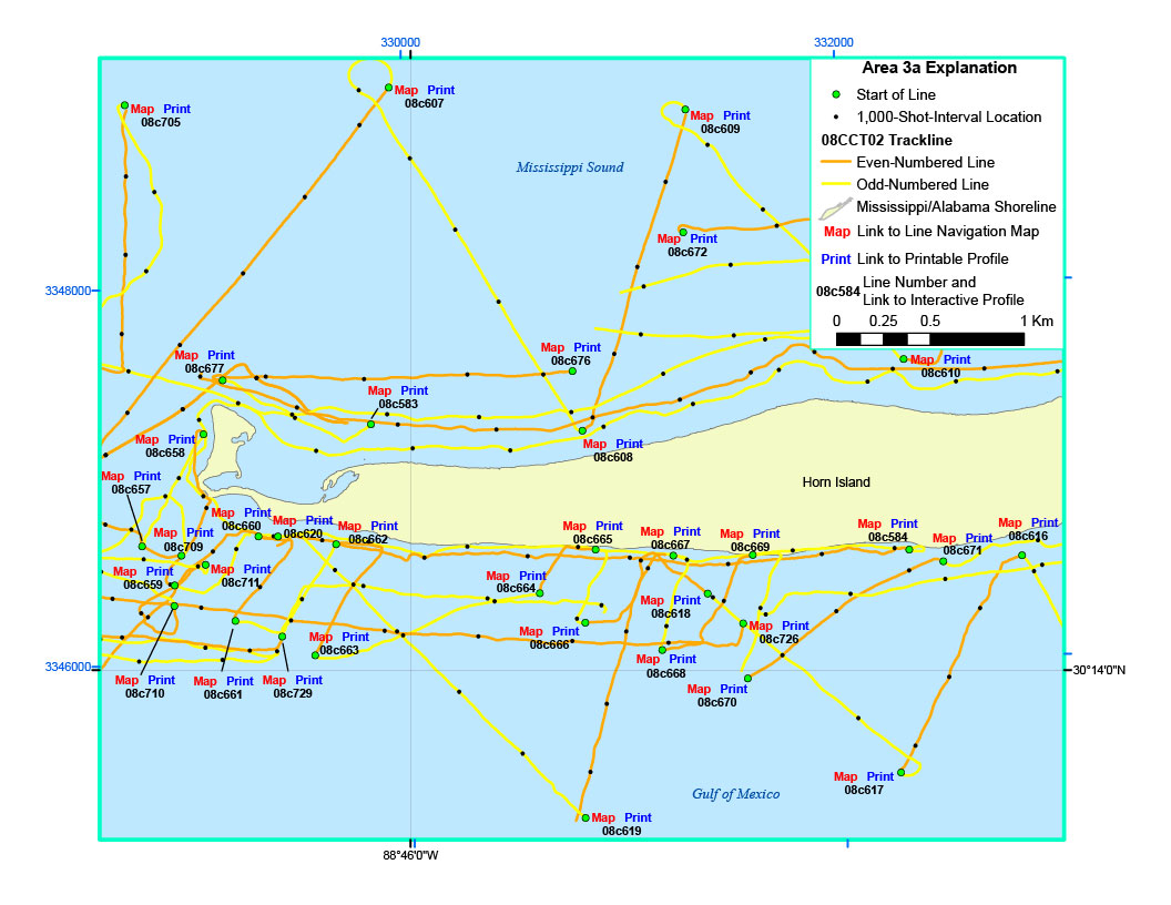
Area 3a Map08c619 interactive profile08c619 line navigation map08c619 printable profile08c616 interactive profile08c616 line navigation map08c616 printable profile08c671 interactive profile08c671 line navigation map08c671 printable profile08c617 interactive profile08c617 line navigation map08c617 printable profile08c584 interactive profile08c584 line navigation map08c584 printable profile08c669 interactive profile08c669 line navigation map08c669 printable profile08c726 interactive profile08c726 line navigation map08c726 printable profile08c670 interactive profile08c670 line navigation map08c670 printable profile08c668 interactive profile08c668 line navigation map08c668 printable profile08c618 interactive profile08c618 line navigation map08c618 printable profile08c667 interactive profile08c667 line navigation map08c667 printable profile08c665 interactive profile08c665 line navigation map08c665 printable profile08c666 interactive profile08c666 line navigation map08c666 printable profile08c664 interactive profile08c664 line navigation map08c664 printable profile08c663 interactive profile08c663 line navigation map08c663 printable profile08c729 interactive profile08c729 line navigation map08c729 printable profile08c661 interactive profile08c661 line navigation map08c661 printable profile08c710 interactive profile08c710 line navigation map08c710 printable profile08c659 interactive profile08c659 line navigation map08c659 printable profile08c709 interactive profile08c709 line navigation map08c709 printable profile08c711 printable profile08c660 interactive profile08c660 line navigation map08c660 printable profile08c583 interactive profile08c583 line navigation map08c583 printable profile08c677 interactive profile08c677 line navigation map08c677 printable profile08c657 interactive profile08c657 line navigation map08c657 printable profile08c672 interactive profile08c672 line navigation map08c672 printable profile08c620 interactive profile08c620 line navigation map08c620 printable profile08c705 interactive profile08c705 line navigation map08c705 printable profile08c678 interactive profile08c678 line navigation map08c678 printable profile08c711 line navigation map08c711 interactive profile08c607 printable profile08c607 line navigation map08c673 interactive profile08c662 printable profile08c662 line navigation map08c662 interactive profile08c658 printable profile08c658 line navigation map08c658 interactive profile08c608 printable profile08c608 line navigation map08c608 interactive profile08c609interactive profile08c609 line navigation map08c609 printable profile08c676 interactive profile08c676 line navigation map08c676 printable profile

Figure 8. Zoomed-in trackline map of digital sub-bottom profile data collected offshore of Horn Island (refer to Area 3a on the Area 3 map) during USGS field activity 08CCT02.


Location Map | Area 1 | Area 2 | Area 2a | Area 2b | Area 3 | Area 3a | 08CCT03 Map


Home | Acronyms | Contents | Navigation | Profiles | Logs | Metadata | Software

Accessibility FOIA Privacy Policies and Notices

Take Pride in America logo USA.gov logo U.S. Department of the Interior | U.S. Geological Survey
URL: http://
Page Contact Information: Feedback
Page Last Modified: