USGS - science for a changing world

U.S. Geological Survey Data Series 569

Area 1 Map


Home | Acronyms | Contents | Navigation | Profiles | Logs | Metadata | Software


Click on a trackline name to view the interactive profile image, Map to
view the line navigation map, or Print to view the printable profile image.
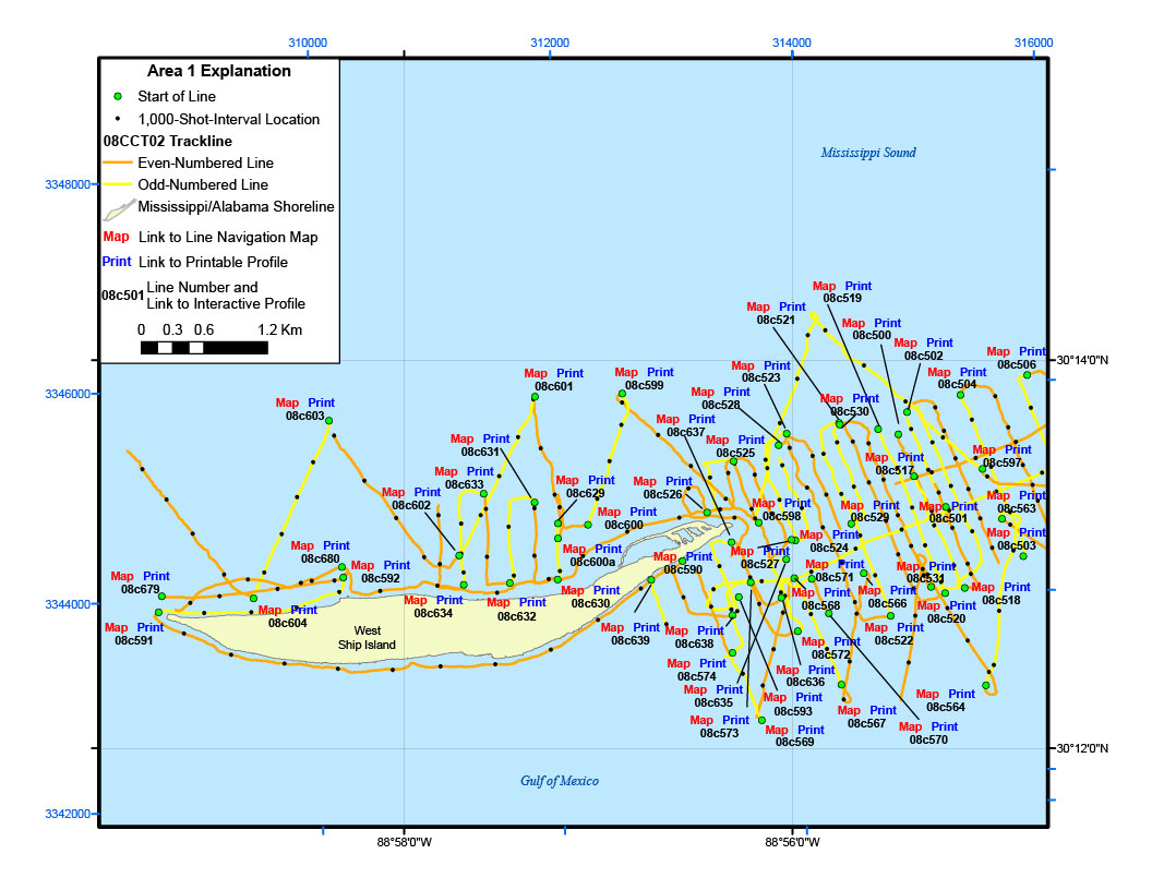
Area 1 Map08c636 interactive profile08c636 printable profile08c636 line navigation map08c570 interactive profile08c570 line navigation map08c570 printable profile08c522 printable profile08c522 line navigation map08c522 interactive profile08c520 printable profile08c520 line navigation map08c520 interactive profile08c566 printable profile08c566 line navigation map08c566 interactive profile08c531 printable profile08c531 line navigation map08c531 interactive profile08c571 printable profile08c571 line navigation map08c571 interactive profile08c524 printable profile08c524 line navigation map08c524 interactive profile08c568 printable profile08c568 line navigation map08c568 interactive profile08c572 printable profile08c572 line navigation map08c572 interactive profile08c593 printable profile08c593 line navigation map08c593 interactive profile08c574 printable profile08c574 line navigation map08c574 interactive profile08c638 printable profile08c638 line navigation map08c638 interactive profile08c639 printable profile08c639 line navigation map08c639 interactive profile08c637 printable profile08c637 line navigation map08c637 interactive profile08c527 printable profile08c527 line navigation map08c527 interactive profile08c590 printable profile08c590 line navigation map08c590 interactive profile08c630 printable profile08c630 line navigation map08c630 interactive profile08c635 printable profile08c635 line navigation map08c635 interactive profile08c573 printable profile08c573 line navigation map08c573 interactive profile08c569 printable profile08c569 line navigation map08c569 interactive profile08c567 printable profile08c567 line navigation map08c567 interactive profile08c564 printable profile08c564 line navigation map08c564 interactive profile08c518 printable profile08c518 line navigation map08c518 interactive profile08c503 printable profile08c503 line navigation map08c503 interactive profile08c598 printable profile08c598 line navigation map08c598 interactive profile08c529 printable profile08c529 line navigation map08c529 interactive profile08c501 printable profile08c501 line navigation map08c501 interactive profile08c563 printable profile08c563 line navigation map08c563 interactive profile08c600 printable profile08c600 line navigation map08c600 interactive profile08c600a printable profile08c600a line navigation map08c600a interactive profile08c632 printable profile08c632 line navigation map08c632 interactive profile08c629 printable profile08c629 line navigation map08c629 interactive profile08c526 printable profile08c526 line navigation map08c526 interactive profile08c591 printable profile08c591 line navigation map08c591 interactive profile08c525 printable profile08c525 line navigation map08c525 interactive profile08c517 printable profile08c517 line navigation map08c517 interactive profile08c528 printable profile08c528 line navigation map08c528 interactive profile08c530 printable profile08c530 line navigation map08c530 interactive profile08c597 printable profile08c597 line navigation map08c597 interactive profile08c523 printable profile08c523 line navigation map08c523 interactive profile08c504 printable profile08c504 line navigation map08c504 interactive profile08c506 printable profile08c506 line navigation map08c506 interactive profile08c502 printable profile08c502 line navigation map08c502 interactive profile08c500 printable profile08c500 line navigation map08c500 interactive profile08c519 printable profile08c519 line navigation map08c519 interactive profile08c521 printable profile08c521 line navigation map08c521 interactive profile08c599 printable profile08c599 line navigation map08c599 interactive profile08c601 printable profile08c601 line navigation map08c601 interactive profile08c631 printable profile08c631 line navigation map08c631 interactive profile08c633 printable profile08c633 line navigation map08c633 interactive profile08c602 printable profile08c602 line navigation map08c602 interactive profile08c634 printable profile08c634 line navigation map08c634 interactive profile08c592 printable profile08c592 line navigation map08c592 interactive profile08c604 printable profile08c604 line navigation map08c604 interactive profile08c680 printable profile08c680 line navigation map08c680 interactive profile08c603 printable profile08c603 line navigation map08c603 interactive profile08c679 printable profile08c679 line navigation map08c679 interactive profile08c591 interactive profile08c591 line navigation map08c591 printable profile

Figure 3. Trackline map of digital sub-bottom profile data collected offhore of West Ship Island (refer to Area 1 on the location map) during USGS field activity 08CCT02.


Location Map | Area 1 | Area 2 | Area 2a | Area 2b | Area 3 | Area 3a | 08CCT03 Map


Home | Acronyms | Contents | Navigation | Profiles | Logs | Metadata | Software

Accessibility FOIA Privacy Policies and Notices

Take Pride in America logo USA.gov logo U.S. Department of the Interior | U.S. Geological Survey
URL: http://
Page Contact Information: Feedback
Page Last Modified: