USGS - science for a changing world

U.S. Geological Survey Data Series 611

10CCT02 Area 2 Map


Home | Acronyms | Contents | Navigation | Profiles | Logs | Metadata | Software


Location Map | 10CCT01 | 10CCT02 | 10CCT03 | 10CCT02 Area 1 | 10CCT02 Area 2 | 10CCT02 Area 3 | 10CCT02 Area 4


Click on a trackline number to view the geospatial profile image.
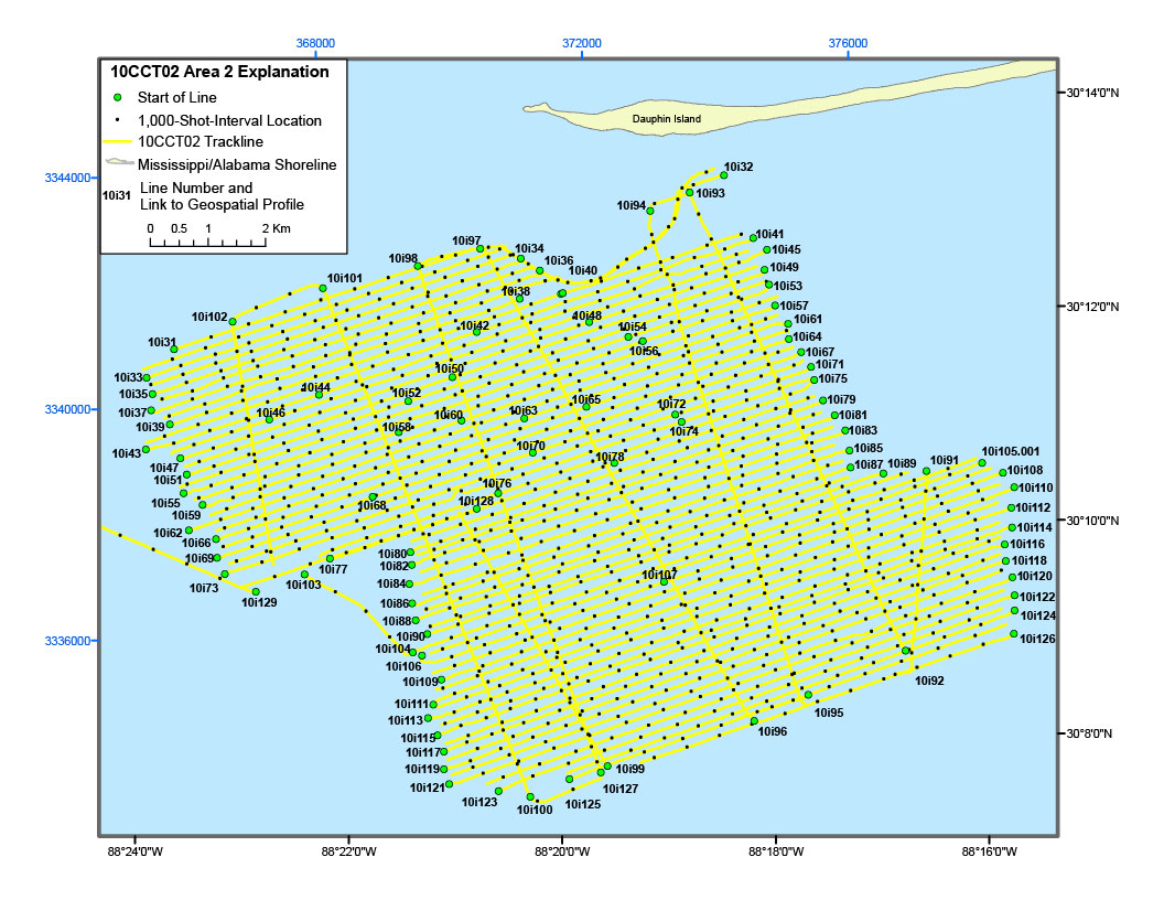
10CCT02 Area 2 Location Map10i73 Geospatial Profile10i69 Geospatial Profile10i66 Geospatial Profile10i62 Geospatial Profile10i59 Geospatial Profile10i55 Geospatial Profile10i51 Geospatial Profile10i47 Geospatial Profile10i43 Geospatial Profile10i39 Geospatial Profile10i437line navigation map10i35 Geospatial Profile10i33 Geospatial Profile10i31 Geospatial Profile10i77 Geospatial Profile10i68 Geospatial Profile10i102 Geospatial Profile10i129 Geospatial Profile10i103 Geospatial Profile10i101 Geospatial Profile10i128 Geospatial Profile10i107 Geospatial Profile10i46 Geospatial Profile10i44 Geospatial Profile10i58 Geospatial Profile10i52 Geospatial Profile10i60 Geospatial Profile10i76 Geospatial Profile10i63 Geospatial Profile10i70 Geospatial Profile10i78 Geospatial Profile10i65 Geospatial Profile10i50 Geospatial Profile10i42 Geospatial Profile10i74 Geospatial Profile10i72 Geospatial Profile10i56 Geospatial Profile10i54 Geospatial Profile10i48 Geospatial Profile10i38 Geospatial Profile10i98 Geospatial Profile10i97 Geospatial Profile10i34 Geospatial Profile10i36 Geospatial Profile10i40 Geospatial Profile10i94 Geospatial Profile10i105.001 Geospatial Profile10i108 Geospatial Profile10i110 Geospatial Profile10i112 Geospatial Profile10i114 Geospatial Profile10i116 Geospatial Profile10i118 Geospatial Profile10i120 Geospatial Profile10i122 Geospatial Profile10i124 Geospatial Profile10i126 Geospatial Profile10i127 Geospatial Profile10i125 Geospatial Profile10i100 Geospatial Profile10i123 Geospatial Profile10i121 Geospatial Profile10i119 Geospatial Profile10i117 Geospatial Profile10i115 Geospatial Profile10i113 Geospatial Profile10i111 Geospatial Profile10i109 Geospatial Profile10i106 Geospatial Profile10i93 Geospatial Profile10i32 Geospatial Profile10i91 Geospatial Profile10i92 Geospatial Profile10i95 Geospatial Profile10i96 Geospatial Profile10i99 Geospatial Profile10i41 Geospatial Profile10i45 Geospatial Profile10i49 Geospatial Profile10i53 Geospatial Profile10i57 Geospatial Profile10i61 Geospatial Profile10i64 Geospatial Profile10i67 Geospatial Profile10i71 Geospatial Profile10i75 Geospatial Profile10i79 Geospatial Profile10i81 Geospatial Profile10i83 Geospatial Profile10i85 Geospatial Profile10i87 Geospatial Profile10i89 Geospatial Profile10i104 Geospatial Profile10i90 Geospatial Profile10i88 Geospatial Profile10i86 Geospatial Profile10i84 Geospatial Profile10i82 Geospatial Profile10i80 Geospatial Profile

Figure 5B. Detailed trackline map of digital subbottom profile data collected during USGS field activity 10CCT02, between Petit Bois and Dauphin Islands (refer to Area 2 on figure 4 for location).


Home | Acronyms | Contents | Navigation | Profiles | Logs | Metadata | Software

Accessibility FOIA Privacy Policies and Notices

Take Pride in America logo USA.gov logo U.S. Department of the Interior | U.S. Geological Survey
URL: http://pubsdata.usgs.gov/pubs/ds/611/html/10cct02_area2.html
Page Contact Information: GS Pubs Web Contact
Page Last Modified: Monday, 28-Nov-2016 17:28:52 EST