USGS - science for a changing world

U.S. Geological Survey Data Series 611

10CCT02 Area 1 Map


Home | Acronyms | Contents | Navigation | Profiles | Logs | Metadata | Software


Location Map | 10CCT01 | 10CCT02 | 10CCT03 | 10CCT02 Area 1 | 10CCT02 Area 2 | 10CCT02 Area 3 | 10CCT02 Area 4


Click on a trackline number to view the geospatial profile image.
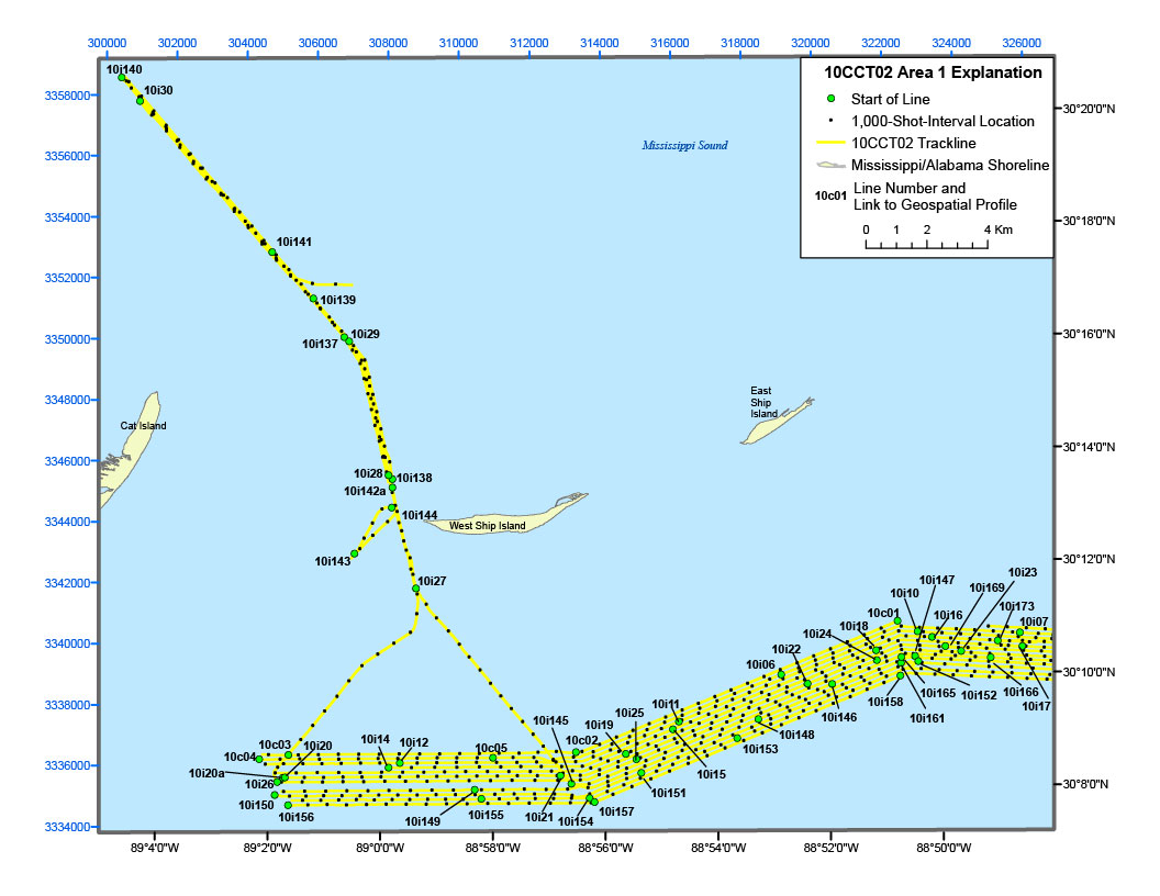
10CCT02 Area 1 Location Map10c01 Geospatial Profile10c02 Geospatial Profile10c05 Geospatial Profile10i147 Geospatial Profile10i169 Geospatial Profile10i173 Geospatial Profile10i16 Geospatial Profile10i15 Geospatial Profile10i23 Geospatial Profile10i07 Geospatial Profile10i17 Geospatial Profile10i10 Geospatial Profile10i18 Geospatial Profile10i24 Geospatial Profile10i22 Geospatial Profile10i06line navigation map10i11 Geospatial Profile10i21 Geospatial Profile10i25 Geospatial Profile10i19 Geospatial Profile10i12 Geospatial Profile10i14 Geospatial Profile10i20 Geospatial Profile10c03 Geospatial Profile10c04 Geospatial Profile10i20a Geospatial Profile10i26 Geospatial Profile10i166 Geospatial Profile10i152 Geospatial Profile10i165 Geospatial Profile10i161 Geospatial Profile10i158 Geospatial Profile10i146 Geospatial Profile10i148 Geospatial Profile10i153 Geospatial Profile10i151 Geospatial Profile10i157 Geospatial Profile10i154 Geospatial Profile10i155 Geospatial Profile10i149 Geospatial Profile10i156 Geospatial Profile10i150 Geospatial Profile10i145 Geospatial Profile10i143 Geospatial Profile10i144 Geospatial Profile10i142a Geospatial Profile10i138 Geospatial Profile10i137 Geospatial Profile10i139 Geospatial Profile10i27 Geospatial Profile10i28 Geospatial Profile10i29 Geospatial Profile10i30 Geospatial Profile10i141 Geospatial Profile10i140 Geospatial Profile

Figure 5A. Detailed trackline map of digital subbottom profile data collected during USGS field activity 10CCT02, offshore from Cat Island to East Ship Island (refer to Area 1 on figure 4 for location).


Home | Acronyms | Contents | Navigation | Profiles | Logs | Metadata | Software