 (also available as a
346K Postscript file),
(also available as a
346K Postscript file),A total of 73,231 water years of daily mean discharge data at 1,659 gaging stations were identified as satisfying the criteria for inclusion in the HCDN. Station identification and basin description information were taken from the WATSTORE Station Header and Basin Characteristics Files, respectively. The station identification information, the basin description information, and any qualifying comments for each station have been summarized in several tables in this report, as discussed below. The tables appear both on paper and in electronic form (on the Hydro-Climatic Data Network Information Disk) in this report. For each station and water year of record deemed to meet the HCDN criteria, the daily mean discharge values were retrieved from the USGS WATSTORE Daily Values File. For each water year included in the HCDN, monthly and annual mean discharge values were computed, and the annual minimum and maximum values of the daily mean discharges were identified. The entire HCDN data set is available through the USGS NAWDEX Office.
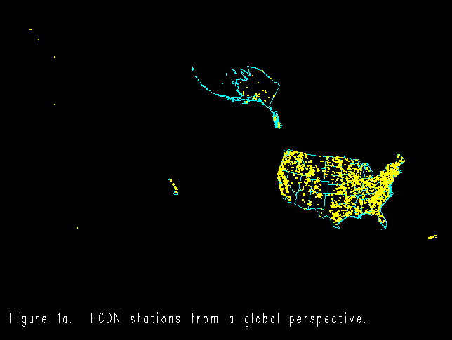
The geographic distribution of the HCDN stations throughout the United States, in relation to State and hydrologic boundaries, is shown in
figure 1a
(also available as a
346K Postscript file),
figure 1b 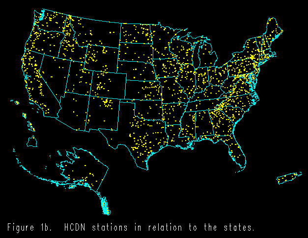 (also available as a
373K PostScript file),
(also available as a
373K PostScript file),
figure 1c 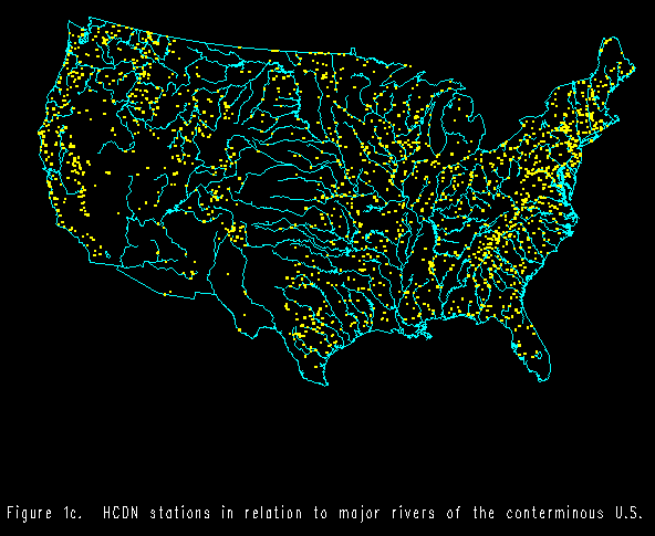 (also available as a
620K PostScript file),
(also available as a
620K PostScript file),
figure 1d 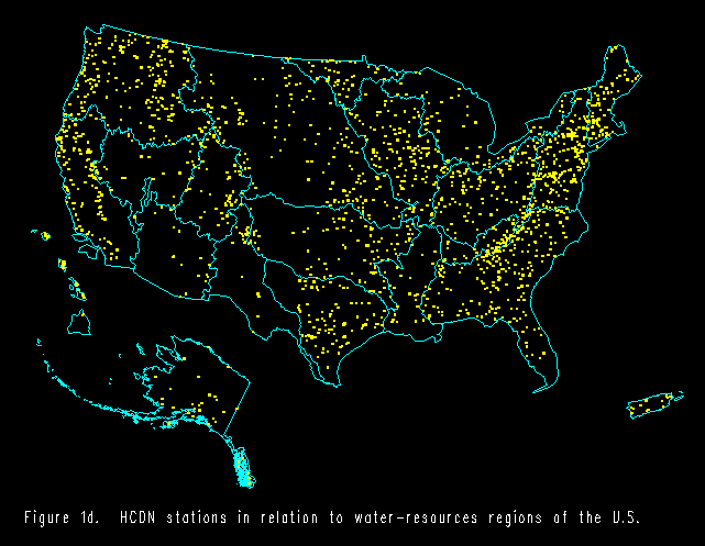 (also available as a
412K PostScript file, and
(also available as a
412K PostScript file, and
figure 1e  (also available as a
1369K PostScript file).
(also available as a
1369K PostScript file).
The network density indicates a natural constraint: there are more streamflow gaging stations in the humid regions of the United States than in the arid zones. The length of acceptable record available at each HCDN station is shown in
figure 2 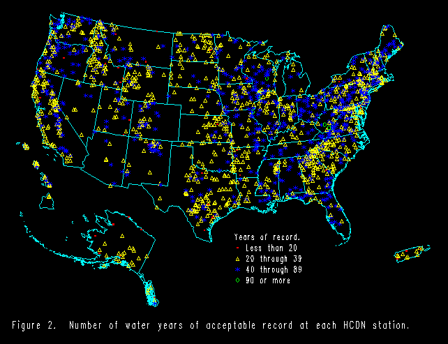 (also available as a
302K PostScript file).
(also available as a
302K PostScript file).
The geographic distribution of the length of acceptable records reflects both the history of the streamflow gaging program of the USGS, which began in the arid regions west of the 100th meridian, and the history of the settlement of the United States, beginning in the humid East. The number of stations with a suitable record of given length, for the range of record lengths, is plotted in
figure 3 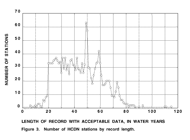 (also available as a
50K PostScript file).
(also available as a
50K PostScript file).
Snapshots of the data set at four different times in the development of the USGS streamflow gaging program are shown in
figure 4 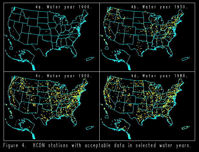 (also available as a
949K PostScript file).
(also available as a
949K PostScript file).
In contrast, the total number of stations for which suitable data is available in any given water year is plotted in
figure 5 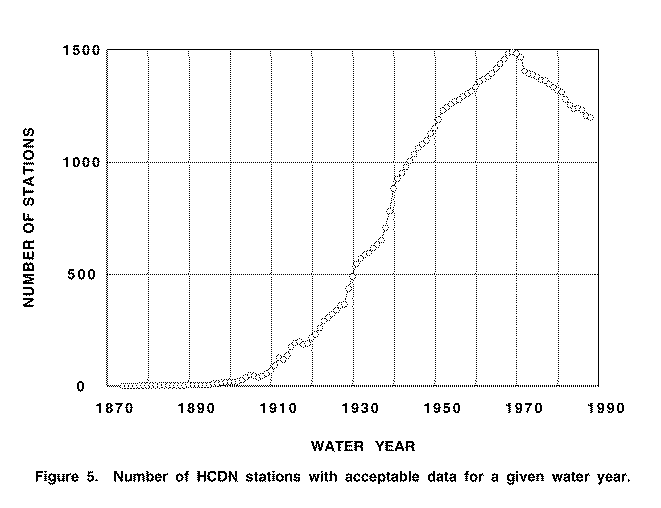 (also available as a
50K PostScript file).
(also available as a
50K PostScript file).
It can be seen that after 1970 there is a national decline in the number of stations for which data is available. This can be attributed to several causes, including (1) a decrease in cooperative funding of streamflow gaging stations by several States, leading to the termination of data collection a sufficient number of sites in those States to have national consequences cumulatively; (2) increased streamflow regulation; and (3) increased urbanization. The geographic distribution of one of the basin characteristics available for the HCDN stations -- namely, the mean annual precipitation within the watershed -- is shown in
figure 6  (also available as a
298K PostScript file).
(also available as a
298K PostScript file).
The figure further emphasizes the occurrence of streamflow gaging stations in humid areas. The geographic distribution of the size of the drainage areas for the HCDN stations is shown in
figure 7 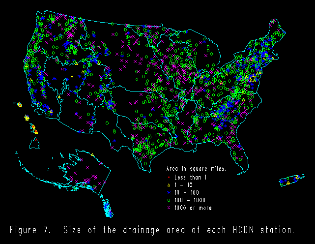 (also available as a
367K PostScript file).
(also available as a
367K PostScript file).
This information is also summarized in
figure 8 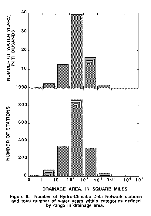 (also available as a
41K PostScript file),
(also available as a
41K PostScript file),
where the number of stations and the total number of suitable water years of daily mean discharge available are plotted over the range of sizes of the drainage areas of the HCDN stations.
A complete compilation of all of the station identification and descriptive information as well as any qualifying comments for each station are given in table 1 (890K text). The HCDN station entries are given in order by USGS station number. The identifying information was taken primarily from the USGS WATSTORE Station Header file. (This file is called STATIONS.DAT - 208K text). It includes the USGS station number, the name of the station (reproduced exactly as officially given in the Station Header file), the latitude and longitude of the station, and the State and a code for the County in which the station is located. (The County codes are found in Appendix C, Chapter 3, Volume I, of the WATSTORE User's Guide by Hutchinson and others, 1975, and correspond to the Federal Information Processing Standards; i.e., FIPS, codes.) If the USGS District office responsible for the maintenance of the station is in a State other than that in which the station is located, the responsible District office is also identified. The 8-digit Hydrologic Unit Code (HUC), which uniquely identifies the geographic area representing part or all of the drainage basin is given for the station. (See Seaber and others, 1987, for a description of the delineation of hydrologic units.) (See HUCS.TXT). The first two digits of the HUC denote in which of the 21 water- resources regions within the United States and its territories the station is located. (See SREGIONS.DAT). The gage datum, which serves as a reference point in determining stage and may be assigned to any arbitrary reference point, is given here because it usually corresponds to the approximate height above sea level (NGVD of 1929) at the gage. The drainage area of the stream at the specific station location is provided, and the percentage of noncontributing area is given only if there is any such in the drainage basin. In addition, if the station is a National Water Conditions Stream Index or Hydrologic Benchmark Network station, it is so identified.
NGVD of 1929 -- National Geodetic Vertical Datum of 1929 is a geodetic datum derived from a general adjustment of the first order level nets of both the United States and Canada. It does not necessarily represent local mean sea level at any particular place.
Any comments about the record available for the station in the HCDN are given in table 1 (890K text). These include any qualifications about watershed conditions with respect to the suitability of the record as defined by the HCDN criteria as well as explanations for short records, as needed. If only monthly mean discharge values or if only a part of the entire period of record are accepted for inclusion in the HCDN, this is noted in the comments for the station, as well. Finally, an explanation is provided for rejecting any Hydrologic Benchmark Network or National Water Conditions station, if it was deemed unacceptable for inclusion in the HCDN. (Note that a list of just the comments for each station can be found in the file COMMENTS.DAT - 122K text).
Finally, table 1 (890K text) provides a snapshot of the length of acceptable record available for the station. The number of water years for which data is acceptable by the HCDN criteria is given, along with a graphical depiction of the acceptable water years in the station's record. Water years for which the data is acceptable are denoted by an "*" on the dashed time line, which begins in water year 1874 and runs through water year 1988. (See also STATIONS.DAT - 208K textand WYEARS.DAT - 221K text).
For ease in searching for stations by location or by length of record, the contents of table 1 (890K text) are restated in tables 2 (222K text) and table 3 (262K text), respectively. Stations are listed in order of station number. Table 2 provides a concise summary of the station identification information given in table 1 for each HCDN station, as well as for any Hydrologic Benchmark Network or National Water Conditions station even if rejected, that is, deemed unacceptable for inclusion in the HCDN as defined by the criteria discussed above. (Table 2 corresponds to the file STATIONS.DAT - 208K text) . Table 3 (262K text) provides a summary of the record available at each station, giving both the number of water years of suitable data and the time line that graphically depicts the acceptable water years in the record available for the station. (Table 3 corresponds to the file WYEARS.DAT - 221K).
Table 4 (232K text)contains the values of 11 watershed characteristics for each station in the HCDN, as taken from the WATSTORE Basin Characteristics File. (This file is called BASINS.DAT - 185K file). These include main channel slope, stream length from gage to basin divide, mean basin elevation (measured from topographic maps by transparent grid sampling method), surface storage area of lakes, ponds and swamps in percent of contributing drainage area, area of lakes and ponds in percent of contributing drainage area, forested area in percent of contributing drainage area, area of glaciers in percent of contributing drainage area, soil (infiltration) index from the Soil Conservation Service, mean annual precipitation, precipitation intensity in 24 hours expected on the average of once each 2 years, and the mean minimum January temperatures. (For a further discussion of these characteristics, see Thomas and Benson, 1970, or Dempster, 1983.) Unlike the discharge data and the station identifying information in the previous tables, the values given in table 4 (232K text) were taken with minimal review from WATSTORE.
The WATSTORE Basin Characteristics file was created for use in regional streamflow regression studies in 1970 (U.S. Geological Survey, written communication, 1970; also, discussed by Benson and Carter, 1973). It was last updated nationally in 1978 (U.S. Geological Survey, written communication, 1977) for a minimum set of required characteristics. These included all but three of those given in table 4 (232K text), namely, area of lakes and ponds in percent of contributing drainage area, area of glaciers in percent of contributing drainage area, and soil (infiltration) index. Since that time, the file has been maintained and updated on a State-specific and generally study-specific basis by many different people. Consistent edit procedures were implemented in 1981. Although much of the information in the Basin Characteristics File warrants an "excellent" or "good" accuracy rating, it should be noted that the contents of the file has been subject to variable quality control measures over time. However, the data are of sufficient accuracy for qualitative comparisons and the information is valuable for its aggregate availability. It is provided in table 4 (232K text) as auxiliary information for the HCDN stations. (Table 4 corresponds to the file BASINS.DAT - 185K text).
Any stations found in either the National Water Conditions Streamflow Index set or in the Hydrologic Benchmark Network for which the available discharge records were considered to be unacceptable for inclusion in the HCDN are given in table 5 . The stations are specifically noted here as exceptions because the discharge records available for these stations have frequently been used to study hydrologic variation in relation to climatic conditions, an objective of the HCDN. The list of stations not included in the HCDN although they are found in either the National Water Conditions Streamflow Index set or in the Hydrologic Benchmark Network totals 44, including 39 that have been used in the monthly National Water Conditions Reports and 5 that have been part of the Hydrologic Benchmark Network.
The distribution of the HCDN station information among the 21 water-resource regions is summarized in table 6. The table gives not only the number of stations per region but also the total number of water years for which the data are acceptable by the HCDN criteria. The stations are further differentiated into those for which the records of daily mean discharge are acceptable by the HCDN criteria and those for which only monthly mean discharge values are acceptable, as well as into those stations for which the entire period of record is acceptable in contrast to only part of the available record. For most stations, the entire period of record is acceptable according to the HCDN criteria, even with regard to daily mean discharge values.
The following files provide identifying information about the stations of the Hydro-Climatic Data Network:
Continue to Summary , or return to Table of Contents
| AccessibilityFOIAPrivacyPolicies and Notices | |
 |
|