
![]()
U.S. DEPARTMENT OF THE INTERIOR
U.S. GEOLOGICAL SURVEY
Coal availability in the Hilight quadrangle, Powder River Basin, Wyoming: a prototype study in a western coal field
by Carol L. Molnia, Laura R. H. Biewick, Dorsey Blake, Susan J. Tewalt, M. Devereux Carter (US Geological Survey), and Charlie Gaskill (Bureau of Land Management)
Open-File Report 97-469
This report is preliminary and has not been reviewed for conformity with U.S. Geological Survey editorial standards and stratigraphic nomenclature. Any use of trade, product, or company names in this publication is for descriptive purposes only and does not imply endorsement by the U.S. Government.
Contents
Abstract
Acknowledgments
Background and Purpose of Study
Geologic
Setting and Coal Mining
Factors
Affecting Availability of Coal Resources
Unsuitability
Criteria Determinations for the Hilight Quadrangle
(a)
Unsuitability Criteria that are Restrictions to Mining
(b)
Unsuitability Criteria that are Considerations in Mining and Mine Planning
Other
Considerations to Mining (in addition to those in the Unsuitability Criteria)
(a)
Multiple-Use Issues
(b)
Technologic Factors
Grouping
of Constraints to Mining in the Hilight Quadrangle
Major
Coal Zones Studied
Computer
Techniques
Results
Coal
Availability Calculation Using Category 1 Restrictions (Likely
restrictions to mining)
Coal
Availability Calculation Including Category 2 Restrictions (Considerations
that probably will be mitigated)
Comparison
to Other Coal Availability Studies
Comparison
to Other Coal Resource Calculations for the Quadrangle
References
Contact
Tables
Table 1. List
of possible restrictions
Table
2. Constraints to mining in the Hilight quadrangle
Table 3. Summary of coal resources
and available coal, by coal bed
Appendix
Tables 4 -13. Coal Resource tables: the following 3 tables
[a,b,c] for each bed listed below; for both Category 1 restrictions [present
land-use and technologic restrictions] and Category 2 restrictions [possible
additional land-use and technologic restrictions].
a) Summary table showing original, remaining, and available
resources.
b) Coal tonnage unavailable, by specific land-use restriction.
c) Coal tonnage unavailable, by specific technological restriction.
Table 4a, b, c. -- Main Wyodak bed, Category 1
Table 5a, b, c. -- Rider Wyodak bed, Category 1
Table 6a, b, c. -- Lower Wyodak bed, Category 1
Table 7a, b, c. -- Wildcat bed, Category 1
Table 8a, b, c. -- Moyer bed, Category 1
Table 9a, b, c. -- Main Wyodak bed, Category 2
Table 10a, b, c. -- Rider Wyodak bed, Category 2
Table 11a, b, c. -- Lower Wyodak bed, Category 2
Table 12a, b, c. -- Wildcat bed, Category 2
Table 13a, b, c. -- Moyer bed, Category 2
Figures
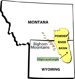
Figure 1. Map showing
location of the Powder River Basin and the Hilight 7 1/2 -minute quadrangle.
Figure 2. Map showing locations of surface coal mines near the Hilight 7 1/2 -minute quadrangle.
Figure 3. Map showing data points used for this study.
Figure 4. Generalized composite stratigraphic section for the Hilight quadrangle.
Figure 7. Map showing additional land-use features of the Hilight quadrangle.
Figure 9. Coal correlation diagram showing representative sections from the Hilight study area.
Figure 10. Coal-correlation diagram A- A', showing coal beds in the Wyodak coal interval.
Figure 11. Enlargement of coal-correlation diagram A- A'.
Figure 12. Chart showing total original coal resources in the Hilight quadrangle.
Figure 13. Chart showing amount of available coal in Hilight quadrangle (Category 1 restrictions).
Abbreviations and Conversions
| To convert from
Inches (in.) Feet (ft) Miles (mi) Short tons (2,000 lbs.) |
To
Centimeters Meters Kilometers Metric tons (2,204.6 lbs.) |
Multiply by
2.54 0.3048 1.609344 0.90718474 |
Abstract![]()
The U.S. Geological Survey (USGS), in
cooperation with the Bureau of Land Management (BLM), Geological Survey
of Wyoming, and U.S. Bureau of Mines (USBM), has produced an estimate of
the amount of available coal in an area about 35 miles south of Gillette,
Wyo., where the Wyodak coal bed is, in places, more than 100 ft thick.
Available coal is the quantity of the total coal resource that is accessible
for mine development under current regulatory, land-use, and technologic
constraints. This first western coal availability study, of the Hilight
7 1/2-minute quadrangle, indicates that approximately 60 percent (2.7 billion
short tons) of the total 4.4 billion tons of coal in-place in the quadrangle
is available for development. (There has been no commercial mining in the
Hilight quadrangle.) Approximately 67 percent (1.9 billion tons) of the
Main Wyodak coal bed is considered available. All tonnage measurements
in this report are given in short tons.
Coal-development considerations in the quadrangle include dwellings, railroads, pipelines, power lines, wildlife habitat (eagles), alluvial valley floors, cemeteries, and the Hilight oil and gas field and gas plant. Some of these considerations could be mitigated so that surface mining of the coal may proceed; others could not be mitigated and would preclude mining in their vicinity. Other technological constraints that influence the availability of the coal include overburden thickness, coal beds too thin, and areas of clinker.
Acknowledgments![]()
We could not have successfully completed
this project without the help of Vickie L. Clark, the U.S. Geological Survey
computer system administrator. Employees of the U.S. Bureau of Mines Coal
Recoverability Program -- Timothy J. Rohrbacher, Lee M. Osmonson, Gerald
L. Sullivan, David C. Scott, and Dale D. Teeters -- were extremely helpful
with describing local mining practice and assisting with GIS (geographic
information systems) software. The Wyoming State Geological Survey supplied
information and helped with project logistics. James E. Fassett and Timothy
J. Rohrbacher reviewed the manuscript and offered thoughtful and constructive
comments. Sally J. Dyson, Robert K. Wells, Cheryl W. Adkisson, and Richard
P. Walker assisted in preparing a digital version of this report to appear
as a World Wide Web release.
Background and Purpose of
Study![]()
Traditional Federal and State coal resource
estimates have not taken into account the multitude of land-use, environmental,
regulatory, technologic, and economic restrictions to coal mining and coal
resource recoverability. This has led some Federal, State, and local planners
to overestimate the future supply of the Nation's coal. A cooperative program,
referred to as "Coal Availability," between the U.S. Geological
Survey and other Federal agencies and State geological surveys, was initiated
in 1986 to identify major constraints on the availability of coal resources
for development and to estimate the amount of remaining coal resources
that may be accessible for development under those constraints (Carter
and Gardner, 1989, 1994; Eggleston and others, 1990). Coal availability
studies have been done at the 7 1/2-minute-quadrangle scale; the results
are modeled statistically and can be indicative of larger areas that have
similar developmental restrictions and geologic conditions.
The data generated during the coal availability studies were shared with the U.S. Bureau of Mines for use in their coal recoverability studies, where recovery and cost factors were applied to the estimated available coal resources. This results in an estimate of the amount of economically recoverable coal [coal reserves], which is usually far less than the amount available for development (Rohrbacher and others, 1994).
The coal availability program was first conducted in the Eastern United States. The results there (see Comparison to Other Coal Availability Studies section of this report) were useful to the coal mining industry and other resource managers. Seventeen quadrangles were modeled in the central Appalachian region of West Virginia, Kentucky, and Virginia. Coal availability studies have expanded into the northern Appalachian region, the Illinois Basin, and the Western United States. There was great interest in extending the program to western coal fields to see what factors would be involved and how the process could be applied to the different geologic and mining conditions in the Western United States. The Hilight quadrangle study is the first coal availability study in the western United States.
[To Top of Page] [To Next Page] [To Central Region Energy Team]
U.S. Geological Survey Open-File Report 97-469

![]() U.S. Department of the Interior | U.S. Geological Survey
U.S. Department of the Interior | U.S. Geological Survey
URL: http://pubsdata.usgs.gov/pubs/of/1997/ofr-97-0469/OF-97-469.html
Page Contact Information: Central Energy Data Management
Questions or Assistance: Contact USGS
Last modified: Wednesday, 07-Dec-2016 16:31:50 EST