Photographs of the Sea Floor Offshore of New York and New Jersey, USGS Open-File Report 01-470
Title Page / Contents / Software / Introduction / Photo System / Photographs / Movies / Acknowledgments / References / List of Figures
Appendices: I. Bottom Photographs / II. Sea Floor Movies / III. Sediment Texture / IV. ArcView Project / V. Metadata
Appendix III: Sediment Texture
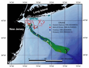 |
Figure 8. Map showing sediment sample locations. The PDF format provides a larger map. See the individual cruise maps (Appendix I) for maps showing the station numbers in the excel file. |
The surficial sediment texture analyses from all stations are presented in an Excel file. See Poppe and others (2000), for a description of the procedures for sediment texture analysis and Hastings and others (2000, URL: https://pubs.usgs.gov/of/of00-358/) for a data dictionary describing the column headings in the table. Abbreviated surficial sediment texture information is available on the station pages in Appendix I.
To view files in PDF format, download free copy
of Adobe Acrobat Reader,
(URL: http://www.adobe.com/products/acrobat/alternate.html).