| |  |  | | Lake Pontchartrain Atlas: | | | | | | | | | | | | | | | | | | | | | | | | | | | | | | | Environmental Issues |  | | | | | | | | | | | | | |  | | | | | | | | | | |  | Environmental Issues - Bonnet Carré Diversion: March 17 - April 18, 1997 Contributors: Haralampides, McCorquodale Bonnet Carré Spillway It is important to estimate the magnitude and direction of the water movement in order to predict the impact of various scenarios on the water quality of an ecosystem. In Lake Pontchartrain, models can help to predict the fate of pollutants such as nutrients and bacteria entering the Lake from outfall canals, fresh water and sediments diverted through the Bonnet Carré Spillway or by storm fronts. Fine-grained sediments such as clay and silt can adsorb and transport toxic contaminants. Such pollutants can enter with high velocities when the Spillway is open and can deposit within the Lake where the currents are low. Lake Pontchartrain is very shallow, allowing even a light wind to resuspend bed sediments. The compounds are thus re-introduced to the water column, affecting fish and other biota. The Pontchartrain Ecosystem Research and Education Project The Pontchartrain Ecosystem Research and Education Project at UNO has conducted a monitoring program that began when the Bonnet Carré Spillway was opened in March 1997 and has continued to present. This period includes a number of significant hydrologic events: a Spillway opening, an extensive drought, a record winter rainfall, several tropical storms and Hurricane Georges. Very dynamic changes in the salinity and water surface elevations in Lake Pontchartrain were observed. The numerical models were able to simulate these conditions in the Lake for the various scenarios. 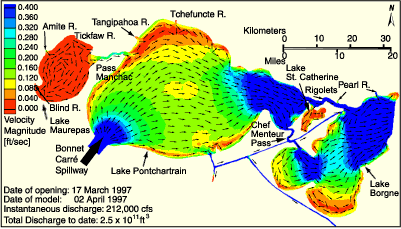 | | Figure 54: Lake Circulation Patterns: Simulation of the 1997 Bonnet Carré Spillway opening. Click on the image for a larger version. | The results of a simulation of the 1997 Bonnet Carré Spillway opening are shown in Figure 54. The highest velocities are shown to be at the entrance of the Spillway and within the current passes connecting the lakes. The flow from the Spillway dominates the hydrodynamic pattern as the water moves to the east, predominantly through the southern part of the Lake. Numerical modeling is a tool used to investigate the processes and interactions of components of dynamic systems. The effects of wind, storm surges, rainfall events and diversion events on Lake Pontchartrain can be investigated. The exchange of water with Lakes Maurepas and Borgne can also be studied. In order to realistically represent the water movement through the Lake Pontchartrain system, driving forces such as wind, tides and conditions at the boundary with the Gulf of Mexico need to be considered. Fresh water inputs from the major tributaries and periodically from the Bonnet Carré Spillway, as well as salt water entering the Lake through the IHNC and Lake Borgne, have been included in these models. Hydrodynamic models calculate the velocity and water level under specified conditions. In Lake Pontchartrain, the currents in the center of the Lake are quite slow, but higher velocities occur along the shore following in the same direction as the wind. The velocities are also higher because of the narrow geometry through the Rigolets, Chef Menteur Pass and Pass Manchac. During development, the models were calibrated to a data set of observations taken in the field. Historical stage data were also used and were obtained from the USGS and the USACE for various points in the Lake. These data were used to calibrate the numerical models and to verify that these models were reproducing the Lake behavior. Circulation patterns predicted by UNO for specific input conditions were compared with studies completed by Richard Signell of the USGS and found to be similar. « Previous | Next » |
